Kansas, Oklahoma and Missouri Face Growing Tornado Concern for Monday, November 2, as Forecaster Warns the Threat Could Be Higher Than Many Expect
WICHITA, KANSAS — Forecasters are keeping a close eye on Monday, November 2, as a developing storm system could bring a tornado threat to parts of the central Plains and Midwest. While computer models are still all over the place on timing, one forecaster warned that wherever the threat sets up, it could end up much higher than some are expecting.
Tornado Risk Window: 1 p.m. Monday Through 1 a.m. Tuesday EST
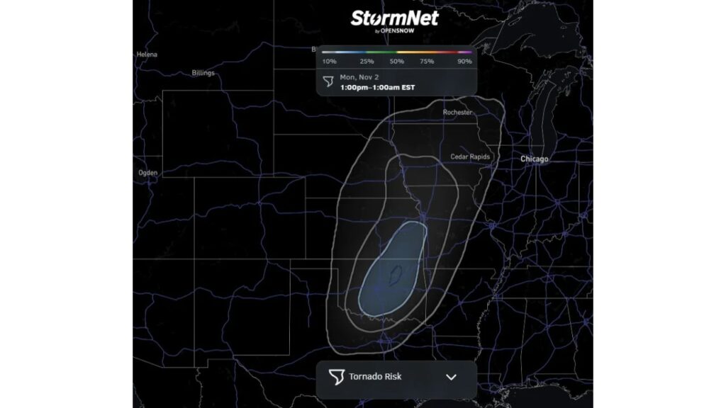
The latest tornado risk outlook from StormNet covers the period from 1 p.m. EST Monday, November 2, through 1 a.m. EST Tuesday, November 3, spanning the afternoon and overnight hours.
Highest Tornado Probabilities Centered on Eastern Kansas and Northeast Oklahoma
The core of the highest tornado risk on the map is centered over:
- Southeast and east-central Kansas
- Northeast Oklahoma
- Areas near the Kansas, Oklahoma and Missouri border region
A smaller, more concentrated area sits inside that core, marking where the signal is strongest at this time.
Broader Tornado Risk Zone Stretches From Oklahoma to Minnesota
Surrounding the core, wider rings of lower tornado probability extend across a large part of the central U.S.:
| Region | Areas Inside the Risk Zone |
|---|---|
| Southern Plains | Much of Oklahoma and far north Texas |
| Central Plains | Eastern Kansas and southeast Nebraska |
| Mississippi Valley | Western Missouri and northwest Arkansas |
| Upper Midwest | Iowa, including Cedar Rapids, and southern Minnesota near Rochester |
Cities like Chicago sit just outside the outlined risk area on this forecast.
Models Still Disagree on Timing
The forecaster noted that a detailed breakdown was planned, but computer models remain inconsistent on when the storm system will arrive. Even small changes in timing could shift which areas face the greatest risk and when storms develop.
“A Much Higher Tornado Threat Than Some Are Expecting”
Despite the uncertainty, the forecaster stressed that the setup has potential. Wherever the threat ends up, there could be a significantly higher tornado risk than many people currently expect.
Part of a Larger Early-November Storm
The tornado concern lines up with a broader strong storm system forecast to develop over the southern and central Plains at the start of November. That system is also expected to bring heavy rain, gusty winds and even a winter weather side farther north and west.
Late-Season Tornadoes Are Not Unusual
While spring is the peak season, November tornadoes do occur across the Plains and Mississippi Valley when warm, humid air clashes with strong fall storm systems. Residents should not let their guard down just because it is late in the year.
How to Prepare Ahead of Monday
People in the risk area should take steps now:
- Identify your safe place, such as a basement or interior room on the lowest floor
- Make sure you have multiple ways to get warnings, including phone alerts and a weather radio
- Charge devices and keep flashlights ready
- Plan ahead for overnight storms, since the risk window extends past midnight
Outlook: Watch Closely as Forecast Details Come Into Focus
Forecasters say they are watching closely and will provide more details as models come into better agreement. Residents across Kansas, Oklahoma, Missouri, Iowa and nearby states should check updated forecasts through the weekend.
Stay with Bchssreport.com for the latest updates on this story.
About The Author
