Colorado’s San Juan Mountains Brace for 1 to 2 Feet of Snow Above 9,000 Feet Sunday and Monday, Raising Hopes for an Early Wolf Creek Opening
DURANGO, COLORADO — A significant snowstorm is looking increasingly likely for the higher peaks of the San Juan Mountains in southwest Colorado on Sunday and Monday, November 1 and 2, with 1 to 2 feet of snow possible above 9,000 feet.
The storm could cause big impacts on mountain roads, but it may also give Wolf Creek Ski Area, and possibly other resorts, the boost they need to open next week.
Storm Timing: Sunday Through Monday, Snow Totals Through Tuesday Morning
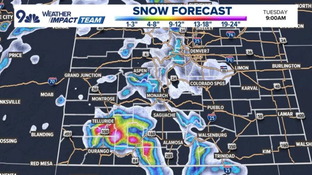
Snow is expected to fall from Sunday into Monday, with the forecast map showing expected totals through 9 a.m. Tuesday, November 3.
Heaviest Snow: San Juans Between Telluride, Durango and Wolf Creek
The brightest colors on the snowfall map, showing the highest totals, are centered over the San Juan Mountains:
| Area | Forecast Snowfall |
|---|---|
| Highest San Juan peaks near U.S. 550 | 19 to 24 inches |
| San Juans between Telluride and Durango | 13 to 18 inches |
| Eastern San Juans near U.S. 160 and Wolf Creek | 9 to 18 inches |
| Lower slopes around the San Juans | 4 to 12 inches |
The heaviest pockets of 19 to 24 inches show up near the U.S. 550 corridor north of Durango and in parts of the eastern San Juans.
Sangre de Cristo Mountains Also in Line for Solid Snow
The Sangre de Cristo Mountains near Walsenburg and Trinidad are also highlighted, with forecast totals of about 4 to 12 inches in the higher terrain.
Central Mountains Near Aspen and Monarch Get Lighter Amounts
Farther north, the central Colorado mountains see lighter totals:
- Around Aspen: about 1 to 8 inches
- Near Monarch Pass: about 1 to 8 inches
- Higher terrain west of Denver: about 1 to 8 inches
Front Range and Eastern Plains: Little to Light Snow
Across the Front Range and eastern plains, snowfall looks light:
- Denver and Colorado Springs: mostly 1 to 3 inches or less in spots
- A small pocket of light snow near Limon
- Pueblo, Lamar, Burlington and Karval: little to no snow on the map
Western Slope Mostly Spared
Lower areas on the Western Slope, including Grand Junction and Montrose, show little to no snow in this forecast. Only small, scattered patches appear over parts of eastern Utah, near Price and Moab.
Big Impacts Expected on Mountain Roads and Passes
With up to 2 feet of snow in the high country, travel could become difficult to dangerous on mountain routes, especially:
- U.S. 550 between Durango and Telluride/Silverton areas
- U.S. 160 over Wolf Creek Pass
- Other high passes across the San Juans
Drivers should expect snow-packed roads, reduced visibility, possible chain laws and closures during the heaviest snow.
Good News for Ski Season: Wolf Creek Could Open Next Week
The fresh snow could be just what Wolf Creek needs to open for the season next week, and it may help other resorts get closer to opening day as well.
Travel Tips for the Weekend Storm
- Check road conditions before heading into the mountains
- Carry chains, blankets, food and water in your vehicle
- Delay mountain travel during the heaviest snow if possible
- Fill up on gas before crossing high passes
Stay with Bchssreport.com for the latest updates on this story.
About The Author
