Illinois, Indiana and Ohio Warm Into the Upper 70s and Low 80s Thursday as Springfield and Carbondale Hit 81 Ahead of a Cold Front and Broken Line of Showers
INDIANAPOLIS, INDIANA — Late October is feeling more like early fall’s warmest days across the Midwest and Ohio Valley, with temperatures climbing into the upper 70s and lower 80s on Thursday, October 29, 2026, ahead of an approaching cold front.
A broken band of rain showers may develop along the front as it pushes southeast through the region.
Afternoon Highs: Warmest Readings at 4 p.m. EDT Thursday
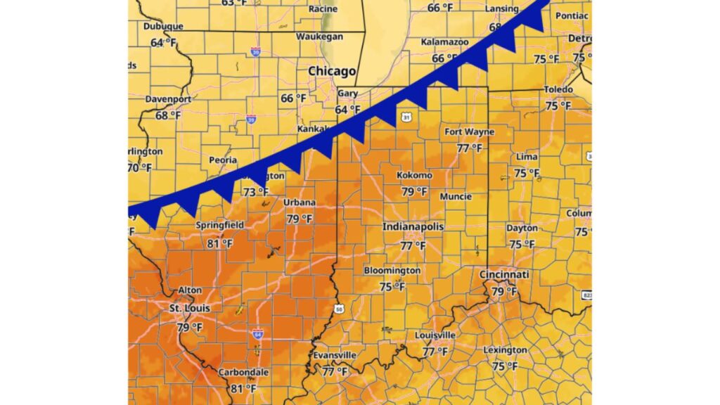
The temperature map for 4 p.m. EDT Thursday shows a sharp split between the warm air ahead of the front and cooler air behind it.
Hottest Spots Ahead of the Front: Springfield and Carbondale at 81 Degrees
| City | State | High Temperature |
|---|---|---|
| Springfield | Illinois | 81°F |
| Carbondale | Illinois | 81°F |
| St. Louis | Missouri | 79°F |
| Urbana | Illinois | 79°F |
| Kokomo | Indiana | 79°F |
| Cincinnati | Ohio | 79°F |
| Indianapolis | Indiana | 77°F |
| Fort Wayne | Indiana | 77°F |
| Louisville | Kentucky | 77°F |
| Evansville | Indiana | 77°F |
| Bloomington | Indiana | 75°F |
| Dayton | Ohio | 75°F |
| Lima | Ohio | 75°F |
| Toledo | Ohio | 75°F |
| Columbus | Ohio | 75°F |
| Detroit | Michigan | 75°F |
| Lexington | Kentucky | 75°F |
| Bloomington | Illinois | 73°F |
Cooler Air Behind the Front: Chicago, Gary and Iowa in the 60s
North and west of the front, temperatures run noticeably cooler:
| City | State | High Temperature |
|---|---|---|
| Burlington | Iowa | 70°F |
| Davenport | Iowa | 68°F |
| Lansing | Michigan | Upper 60s |
| Chicago area | Illinois | 66°F |
| Kalamazoo | Michigan | 66°F |
| Dubuque | Iowa | 64°F |
| Gary | Indiana | 64°F |
Areas farther north near Racine and Waukegan sit in the low to mid 60s.
Where the Cold Front Is Located Thursday Afternoon
The cold front stretches from west-central Illinois northeast through the Kankakee area, past Gary, and into southwest Michigan toward Kalamazoo and Lansing.
Cities south and east of that line are still enjoying the warmth, while those north and west have already started to cool off.
Broken Band of Showers Possible as the Front Pushes Southeast
As the front moves southeast, a broken line of rain showers may form along it. Not every area will see rain, but some spots could get a quick round of showers as the front passes.
What Comes Next: Cooler Temperatures Behind the Front
Once the front sweeps through, places like Springfield, Indianapolis, Cincinnati and Louisville can expect cooler air to follow, bringing temperatures closer to typical late-October levels.
The Contrast Across Illinois
Illinois shows the biggest swing on the map. Springfield and Carbondale reach 81 degrees, while areas near Chicago and Dubuque sit in the mid 60s, a difference of roughly 15 degrees across the state.
Tips for a Warm Day With a Front on the Way
- Enjoy outdoor plans early before showers arrive
- Carry an umbrella in case the broken rain band reaches your area
- Expect cooler air behind the front, so have a jacket ready for later
Stay with Bchssreport.com for the latest updates on this story.
About The Author
