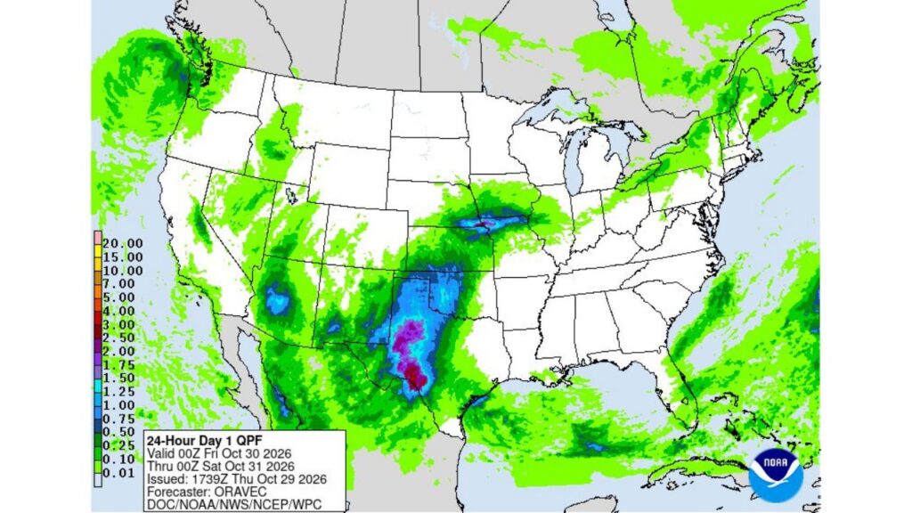
West Texas and Southeast New Mexico Under Flood Watch Through Friday Afternoon as Heavy Rain Bands Could Dump More Than 3 Inches From the Southern Panhandle to Big Bend
WEST TEXAS — A Flood Watch remains in effect through Friday afternoon, October 30, 2026, for much of West Texas and southeast New Mexico, where heavy rain is expected to continue. In the heaviest bands, rainfall totals could top 3 inches, especially from the southern Texas Panhandle down to the Big Bend region.
Forecast Window: Thursday Evening Through Friday Evening
The 24-hour rainfall forecast covers the period from 7 p.m. CDT Thursday, October 29, through 7 p.m. CDT Friday, October 30. It was issued by the Weather Prediction Center on Thursday, prepared by forecaster Oravec.
Heaviest Rain Band: Southern Texas Panhandle to the Big Bend
The most intense rain on the forecast map stretches through west-central Texas, where totals are shown in the highest color ranges:
| Area | 24-Hour Rainfall Forecast |
|---|---|
| Heaviest bands in west-central Texas | 2.5 to 4 inches |
| Southern Texas Panhandle to Big Bend corridor | 1.5 to 3+ inches |
| Surrounding parts of West Texas | 0.75 to 1.5 inches |
Forecasters say more than 3 inches is possible where the heaviest bands set up.
Southeast New Mexico and Western Oklahoma Also Soaked
Rain also spreads beyond the core zone:
- Southeast and eastern New Mexico: about 0.5 to 1.25 inches
- Western Oklahoma: about 1 to 1.5 inches in spots
- Central Arizona: a pocket near 1 inch
Another Pocket of Heavier Rain in the Central Plains
A separate area of 1 to 1.5 inches shows up farther north near the Nebraska, Kansas, Iowa and Missouri border region, while lighter rain extends across parts of Kansas and Missouri.
Lighter Rain Elsewhere Across the Country
Much lighter amounts, mostly under half an inch, are shown across:
- The Pacific Northwest
- Parts of the Great Lakes and Northeast
- The Gulf Coast and Florida
- Scattered areas of the Southwest and Rockies
Large parts of the northern Plains, Midwest and Southeast appear mostly dry during this period.
Why a Flood Watch Is in Effect
A Flood Watch means conditions are favorable for flooding. In West Texas, heavy rain can quickly lead to:
- Flash flooding in draws, arroyos and low-lying areas
- Water-covered roads and low-water crossings
- Rapid rises on creeks and streams
The region’s dry, hard ground can make runoff worse, sending water rushing into drainages faster than usual.
Impacts Through Friday Afternoon
Residents across West Texas and southeast New Mexico should expect:
- Periods of heavy rain that could slow travel
- Possible road closures in flood-prone areas
- Ponding in towns and cities under the heaviest bands
Flood Safety Reminders
- Turn around, don’t drown if water covers the road
- Never drive into low-water crossings during heavy rain
- Stay away from rising creeks and arroyos
- Keep phone alerts on for any flash flood warnings
Outlook: Rain Threat Eases After Friday Afternoon
The Flood Watch is set to expire Friday afternoon, though residents should continue checking local forecasts at weather.gov for updates on rain and flooding in their area.
Stay with Bchssreport.com for the latest updates on this story.
About The Author
