
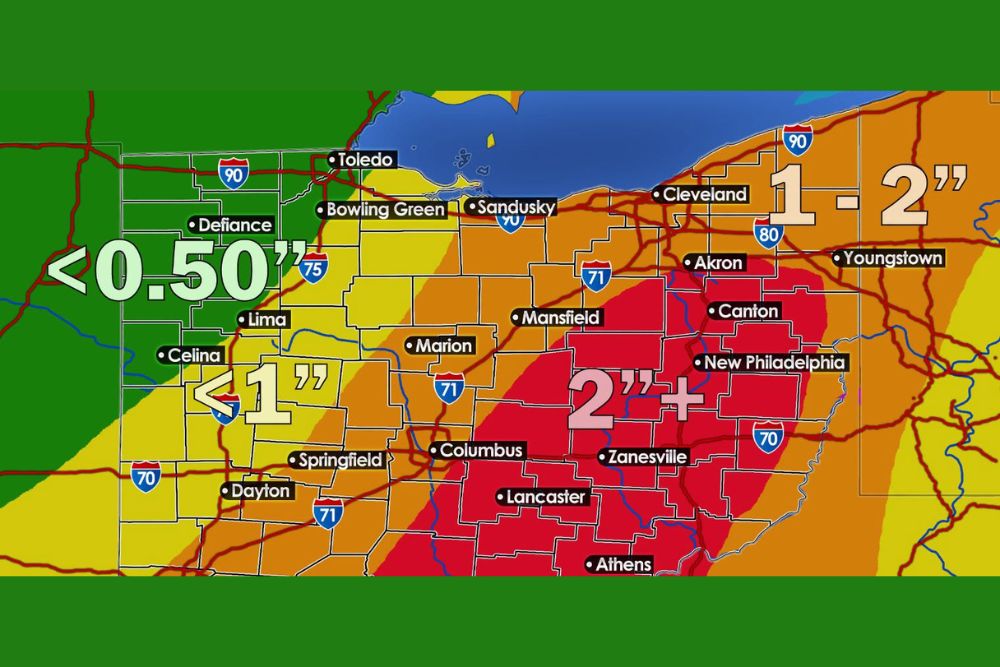
Sunday Soaker for Ohio as Models Shift 2+ Inches of Rain Farther West, With the Heaviest Totals From Columbus to Canton and Zanesville
Ohio – The heavy rain threat for Sunday keeps growing across Ohio, and it’s bad news for anyone with outdoor plans. Forecast models are now showing a more consistent westward shift in the axis of heaviest rain, bringing the potential for 2 inches or more farther west than earlier forecasts suggested. Guidance has also been trending wetter across much of the region as tropical moisture from the remnants of Isaias gets pulled north. Sunday is shaping up to be a widespread soaker, with localized flooding possible where the heaviest rain bands set up.
Where the Heaviest Rain Is Expected
The latest rainfall outlook shows a band of 2 inches or more running through central and eastern Ohio. The zone stretches from Columbus and Lancaster northeast through Mansfield, Akron, Canton, New Philadelphia, and Zanesville, and south toward Athens.
Northeast Ohio, including Cleveland, Sandusky, and Youngstown, is expected to see around 1 to 2 inches of rain. Farther west, totals drop off: Marion, Springfield, and Dayton are forecast to get less than 1 inch, while northwest Ohio, including Toledo, Bowling Green, Defiance, Lima, and Celina, may see less than half an inch.
Westward Shift Getting Close Attention
The biggest change in the forecast is that the 2-inch rainfall zone has moved west. If that trend continues, places that were expected to get lighter rain, including parts of the Columbus metro and central Ohio, could end up with considerably more than first thought.
With tropical moisture involved, heavier rain bands can also form in small areas, producing much higher totals over short distances. One town could get a soaking while another just a few miles away sees noticeably less.
Rain Arrives Saturday Night
Rain is expected to begin spreading into southern Ohio, including the Columbus area, between 9 p.m. and midnight Saturday. From there, it will move north and northeast overnight.
By 3 a.m. to 6 a.m. Sunday, rain should reach much of northern Ohio, with coverage and intensity increasing through the morning.
Sunday Morning Could Be the Wettest Period
Sunday morning, from about 6 a.m. to noon, could be one of the wettest periods of the entire weekend. Widespread moderate, steady rain is expected, with pockets of heavy rain capable of producing impressive rainfall rates. Drivers heading out Sunday morning should expect poor visibility and water on the roads.
Rain Tapers Off From West to East Sunday Afternoon
During Sunday afternoon, areas west of Sandusky should begin to see rain diminish around midday. Communities east of Sandusky, including Cleveland, Akron, Canton, and Youngstown, could keep dealing with periods of rain well into Sunday evening, which will push totals higher in eastern parts of the state.
Localized Flooding Possible
With 2 inches or more possible in the heaviest band, localized flooding is a concern. The greatest risk will be in low-lying areas, poor drainage spots, urban streets, and along small creeks and streams. Fallen leaves can also clog storm drains, making street flooding more likely this time of year.
Drivers should never drive through flooded roads. Just a few inches of moving water can make a vehicle lose control, and deeper water can sweep it away.
Plan Around Sunday
Anyone with outdoor plans on Sunday, including football watch parties, tailgates, youth sports, fall festivals, and pumpkin patch visits, should consider moving them to Saturday, which looks drier for most of the day. Fans heading to Browns games or other outdoor events Sunday should pack rain gear.
Prepare Before the Rain Arrives
Before Saturday night, residents should clear gutters, downspouts, and storm drains, secure outdoor decorations, and move anything that could be damaged by water out of low-lying areas. Homeowners with basements prone to water problems may want to check their sump pumps.
Colder Air Not Far Behind
Once this system moves out, attention turns to a big cooldown expected later next week. Highs could drop into the 40s and low 50s across northern Ohio, with frosty nights and even a chance of a few snowflakes mixing in with showers.
For more Ohio weather updates and Isaias coverage, stay with bchssreport.com.