Southern Texas and the Edwards Plateau Faced Isolated Flash Flooding Threat Thursday as Storms Dropped Up to 2 Inches of Rain Per Hour Near the Rio Grande
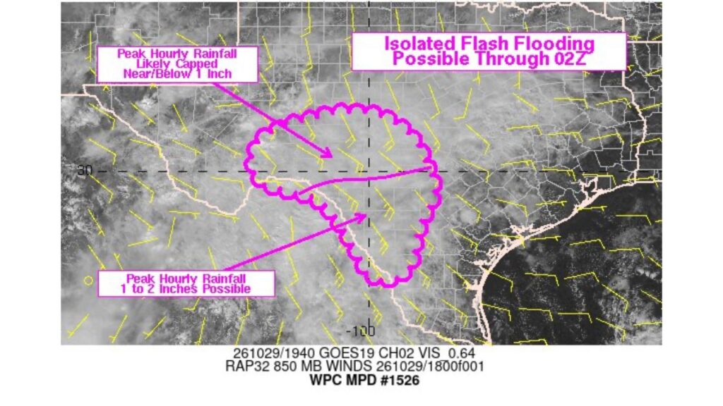
SOUTHERN TEXAS — Parts of southern Texas and the Edwards Plateau were under watch for isolated flash flooding on Thursday, October 29, 2026, as storms capable of dropping 1 to 2 inches of rain per hour developed near the Rio Grande.
The Weather Prediction Center issued Mesoscale Precipitation Discussion #1526 for the area Thursday afternoon, highlighting the risk through the evening hours.
Flash Flood Window: Thursday Afternoon Through 9 p.m. CDT
The flood concern was in place from Thursday afternoon through 9 p.m. CDT (02Z Friday). Satellite imagery used in the discussion was taken at about 2:40 p.m. CDT and showed widespread clouds and developing showers across the region.
Two Zones, Two Different Rainfall Threats
The highlighted area was split into two parts, each with a different level of rainfall intensity:
| Zone | Peak Hourly Rainfall |
|---|---|
| Northern section, Edwards Plateau | Likely capped near or below 1 inch per hour |
| Southern section, near the Rio Grande | 1 to 2 inches per hour possible |
Heaviest Rain Rates Along the Rio Grande in Southern Texas
The southern portion of the area, stretching along and just north of the Rio Grande, carried the greatest concern. Rain falling at 1 to 2 inches per hour can quickly overwhelm dry creek beds, low-water crossings and roadways.
Lighter but Steady Rain Over the Edwards Plateau
Farther north across the Edwards Plateau, rainfall rates were expected to be lower, generally around 1 inch per hour or less. Even so, repeated showers over the same area could still lead to localized runoff in vulnerable spots.
Why Flash Flooding Is a Concern in This Part of Texas
The Edwards Plateau and southern Texas are known for:
- Thin soils and rocky terrain that do not absorb water well
- Steep, narrow drainages that can fill rapidly
- Low-water crossings that can turn dangerous within minutes
That combination means even isolated heavy rain can create sudden flooding.
Southerly Winds Fed Moisture Into the Region
Wind data in the discussion showed southerly and southeasterly winds flowing across Texas a few thousand feet above the ground. That flow helped pull moisture north into the region, supporting the showers and storms.
What “Isolated” Flash Flooding Means
The discussion called for isolated flash flooding, meaning:
- Flooding was not expected everywhere in the highlighted area
- Only specific spots under the heaviest storms were at risk
- Conditions could change quickly where storms lingered or repeated
Flood Safety Reminders for Texas Residents
- Turn around, don’t drown when water covers a road
- Avoid low-water crossings during and after heavy rain
- Stay away from creeks and drainage ditches, which can rise fast
- Keep weather alerts on for any flash flood warnings
Outlook: Threat Expected to Ease After Thursday Evening
The flash flood concern was expected to diminish after 9 p.m. CDT Thursday as storms weakened. Residents in southern Texas and the Edwards Plateau should continue watching local forecasts for any additional rounds of rain.
Stay with Bchssreport.com for the latest updates on this story.
About The Author
