Over 8 Inches of Rain in 24 Hours Unleashes Historic Flooding Along the Georgia-Tennessee Border, With Blue Ridge, McCaysville and Ellijay in the Hardest-Hit Zone
BLUE RIDGE, GEORGIA — More than 8 inches of rain fell in just 24 hours across northern Georgia, triggering historic and catastrophic flash flooding along the Georgia-Tennessee border this week.
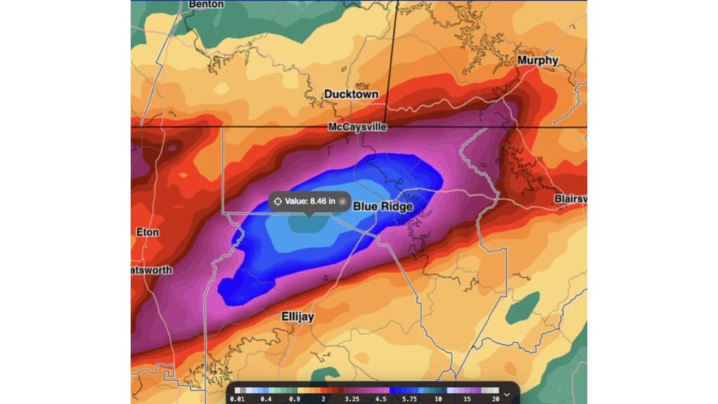
Observed rainfall data showed a peak of 8.46 inches near Blue Ridge, as communities in the mountains dealt with mudslides, water rescues and rapidly rising rivers.
Peak 24-Hour Rainfall: 8.46 Inches Near Blue Ridge
The heaviest rain fell in a narrow band stretching from near Chatsworth in the southwest, through the area west of Blue Ridge, and northeast toward Blairsville.
| Location | Approximate 24-Hour Rainfall |
|---|---|
| Near Blue Ridge, Georgia | 8.46 inches (peak) |
| Core of the band, west of Blue Ridge | About 5.75 to 10 inches |
| McCaysville, Georgia | About 4.5 to 5.75 inches |
| Ellijay, Georgia | About 3.25 to 4.5 inches |
| Areas near Chatsworth and Eton | About 3 to 5.75 inches |
| Toward Blairsville | About 3 to 5 inches |
| Ducktown, Tennessee | About 2 to 3 inches |
| Murphy, North Carolina | About 2 to 3 inches |
| Benton, Tennessee | Under 2 inches |
Border Towns McCaysville and Copperhill Hit Hard
The towns of McCaysville, Georgia, and Copperhill, Tennessee, which sit right on the state line, were among the communities included in Flash Flood Emergencies issued late Wednesday, November 4. The area’s rivers and creeks rose quickly as water rushed off the surrounding mountains.
Why This Flood Is Considered Historic
Rain totals of 8 inches or more in a single day are extremely rare in the north Georgia mountains. When that much rain falls on steep terrain, water funnels into narrow valleys and creeks, causing them to rise within minutes.
Mudslides and Water Rescues Reported
During the height of the flooding, officials reported:
- Mudslides on steep slopes and roads
- Water rescues as homes and vehicles were surrounded by floodwater
- Roads washed out or covered with debris
First Responders Working Around the Clock
First responders have been working nonstop to rescue residents, clear roads and keep communities safe. Many people across the region have shared thoughts and prayers for those affected and the crews helping them.
Part of a Week of Extreme Flooding in the South
This was one of three major flash flood events in the southern U.S. in a single week, along with:
- Pearl River County, Mississippi, where radar estimated up to 18.5 inches
- Palm Bay, Florida, where radar estimated up to 26.1 inches
Forecasters say a strong El Niño and an active subtropical jet stream may be helping fuel these high-end flood events.
How Residents Can Stay Safe During Recovery
- Avoid flooded or damaged roads, which may be weakened
- Stay away from rivers and creeks, which may still be high
- Watch for unstable hillsides after mudslides
- Do not touch downed power lines
- Follow local officials for shelter and cleanup updates
How to Help Flood Victims
- Donate to trusted local relief organizations
- Give blood if local blood banks request it
- Volunteer with recognized groups once it is safe
Outlook: Recovery Begins in the Mountains
As water levels slowly fall, communities in Fannin, Gilmer and Polk counties face a long recovery, with damage assessments expected in the coming days.
Stay with Bchssreport.com for the latest updates on this story.
About The Author
