Baltimore and the Mid-Atlantic Could Go From Muggy and Mild to a Wintry Chill Next Weekend, With One Forecast Even Hinting at the Season’s First Snowflakes
BALTIMORE, MARYLAND — It is rainy, muggy and mild around Baltimore on Friday, November 6, 2026, but next weekend could feel a lot more like winter.
Most forecast models agree that a big chill will settle over the Mid-Atlantic in about 7 to 8 days. One model run goes even further, showing a significant snow event, though forecasters say that outcome is not likely.
From Mild Today to a Big Chill Next Weekend
| Timeframe | Expected Conditions |
|---|---|
| Friday, November 6 | Rainy, muggy and mild around Baltimore |
| About 7 to 8 days later | Much colder air across the Mid-Atlantic |
| Around Saturday, November 14 | Possible first snowflakes for some areas |
Most Forecasts Agree on the Cold
The main takeaway is that colder air is coming. Most forecast guidance shows a strong cool-down for the Mid-Atlantic by next weekend, bringing temperatures that feel more like December than mid-November.
One Forecast Shows a Big Snow Event
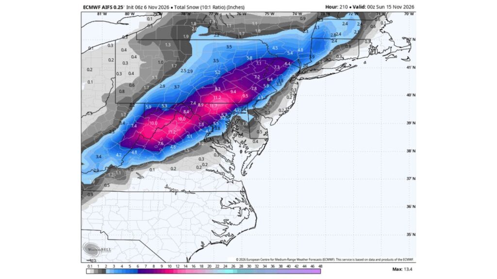
One forecast run, valid through 7 p.m. EST Saturday, November 14, shows a band of heavy snow stretching from the Appalachians into the Northeast. Here is what that single run suggests:
| Area | Snow Shown in This One Forecast |
|---|---|
| West Virginia and western Maryland mountains | About 10 to 11 inches |
| Central and southeast Pennsylvania | About 8 to 11.7 inches |
| Northern New Jersey | About 6 to 8 inches |
| Northeast Pennsylvania | About 5 to 7 inches |
| Baltimore area | About 4 to 5 inches |
| New York City area | About 3 to 4 inches |
| Washington, D.C. | About 1 to 1.5 inches |
| Delmarva Peninsula | Under 2 inches |
| Western New York | About 1 to 3.5 inches |
The highest total on the map tops out at about 13.4 inches.
Forecasters Say a Big Snowstorm Is Unlikely
The forecaster who shared the map was clear: a big snow event is not likely. Forecasts this far out often change a lot, and a single model run showing heavy snow does not mean a storm is coming.
But First Snowflakes Are Possible
While a major storm is unlikely, the cold air arriving next weekend could be enough for some people to see their first snowflakes of the season, especially in higher elevations and areas north and west of Baltimore.
Why Forecasts This Far Out Are So Uncertain
Predicting snow a week or more ahead is very difficult because:
- Storm tracks can shift by hundreds of miles
- Temperatures may end up too warm for snow
- Timing of cold air and moisture must line up perfectly
- Different models often show very different outcomes
A Big Change After a Warm Fall
The potential chill would be a sharp change after a very warm fall in the East, including record warmth earlier this week in places like Buffalo, New York, where temperatures reached 78 degrees.
How to Prepare for the Cold Snap
- Check your heating system before temperatures drop
- Pull out winter coats and gloves
- Protect outdoor plants from possible frost
- Keep an ice scraper in your car
Outlook: Watch for Updates Through the Week
Residents across Maryland, Pennsylvania, New Jersey and the Mid-Atlantic should keep an eye on forecasts as next weekend approaches. The cold looks likely, but any snow is still a big question mark.
Stay with Bchssreport.com for the latest updates on this story.
About The Author
