Ohio Valley, Illinois, Indiana and Michigan Set for 1 to 2+ Inches of Rain as Multiple Storm Systems Roll Through Between November 2 and November 6
OHIO VALLEY — November is starting off wet. Multiple storm systems are expected to move through between November 2 and November 6, bringing widespread rain to the Ohio Valley and much of the Midwest and Great Lakes.
A large part of the region is in line for 1 to 1.5 inches of rain, with heavier totals of 2 inches or more possible in some spots.
Rain Window: Monday, November 2, Through Friday, November 6
The wet stretch is expected to last about five days, with several rounds of rain rather than a single storm. That steady pattern could add up to significant totals by the end of the week.
Projected Rainfall Totals Across the Region
| Rainfall Range | What It Means |
|---|---|
| 1 to 1.5 inches | Expected for a good chunk of the Ohio Valley |
| 2 inches or more | Possible in heavier pockets |
Early Tuesday Snapshot: Rain From Minnesota to the Great Lakes
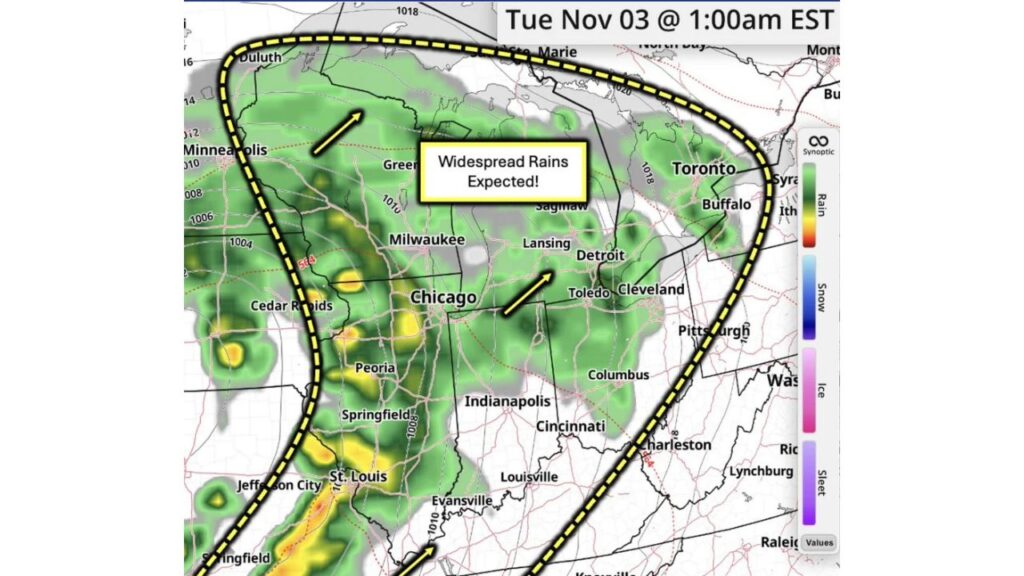
Simulated radar for 1 a.m. EST on Tuesday, November 3, shows a wide band of rain moving through the region. Rain is shown across:
- Minnesota, including Duluth and areas near Minneapolis
- Wisconsin, including Milwaukee and the Green Bay area
- Iowa, near Cedar Rapids
- Illinois, including Chicago, Peoria and Springfield
- Missouri, near St. Louis and Jefferson City
- Michigan, including Lansing, Saginaw and Detroit
- Northern Ohio, including Toledo and Cleveland
- Western New York and Ontario, near Buffalo and Toronto
Heaviest Early Rain Near St. Louis and Central Illinois
The strongest pockets of rain on the Tuesday morning snapshot show up near St. Louis and across central Illinois, where heavier downpours are highlighted in brighter colors.
Moderate rain also appears near Chicago and in parts of eastern Iowa.
Rain Moves Northeast Through the Great Lakes
Arrows on the forecast map show the rain moving northeast, pushing from Illinois and Indiana toward Michigan, northern Ohio and the eastern Great Lakes.
Southern Ohio Valley Mostly Dry at First, but More Rounds Expected
At 1 a.m. Tuesday, cities like Indianapolis, Cincinnati, Louisville, Columbus, Pittsburgh and Charleston appear mostly dry. However, they sit inside the highlighted rain zone, meaning more rounds are expected to reach them during the November 2 to 6 period.
Possible Impacts From Several Days of Rain
Repeated rain over multiple days could lead to:
- Ponding on roads and slower commutes
- Rising creeks and streams in low-lying areas
- Soggy fields and delays for remaining farm work
- Minor flooding where heavier totals of 2 inches or more occur
Rain Relief After a Dry Fall
For parts of the region that have been running dry, the steady rain could help restore soil moisture and boost water levels heading into winter.
Safety Tips for a Wet Week
- Never drive through flooded roads
- Clear gutters and storm drains before the rain arrives
- Give extra time for morning and evening commutes
- Keep weather alerts on for any flood warnings
Outlook: Forecasters Will Keep Tracking the Trends
Forecasters say they will continue monitoring the latest trends, and exact rainfall totals could shift as each system gets closer. Residents across the Ohio Valley, Midwest and Great Lakes should keep checking for updates throughout the week.
Stay with Bchssreport.com for the latest updates on this story.
About The Author
