Northern Illinois and Indiana’s June 11, 2026 Tornado Outbreak Gets a Deep Dive as Forecaster Breaks Down Intense Tornadoes Near Washburn, Streator and Kouts
NORTHERN ILLINOIS — One of the most fascinating severe weather events of the year is getting a closer look. Work has begun on a detailed breakdown of the June 11, 2026, tornado outbreak that swept across northern Illinois and Indiana, producing a string of notable tornadoes, including intense ones near Washburn and Streator, Illinois, and Kouts, Indiana.
The Outbreak at a Glance
| Detail | Information |
|---|---|
| Date | June 11, 2026 |
| Region | Northern and central Illinois and Indiana |
| Notable intense tornadoes | Near Washburn, IL; Streator, IL; Kouts, IN |
| Storm type | Supercell thunderstorms |
| Surprise factor | Eastern storms outperformed western storms |
Chasers Targeted the West, but the East Exploded
On the day of the outbreak, many storm chasers focused on the first supercells that formed across western Illinois. Those storms, however, generally struggled.
Meanwhile, multiple supercells erupted farther east and quickly became the main event, producing a rash of tornadoes across northern Illinois and into Indiana.
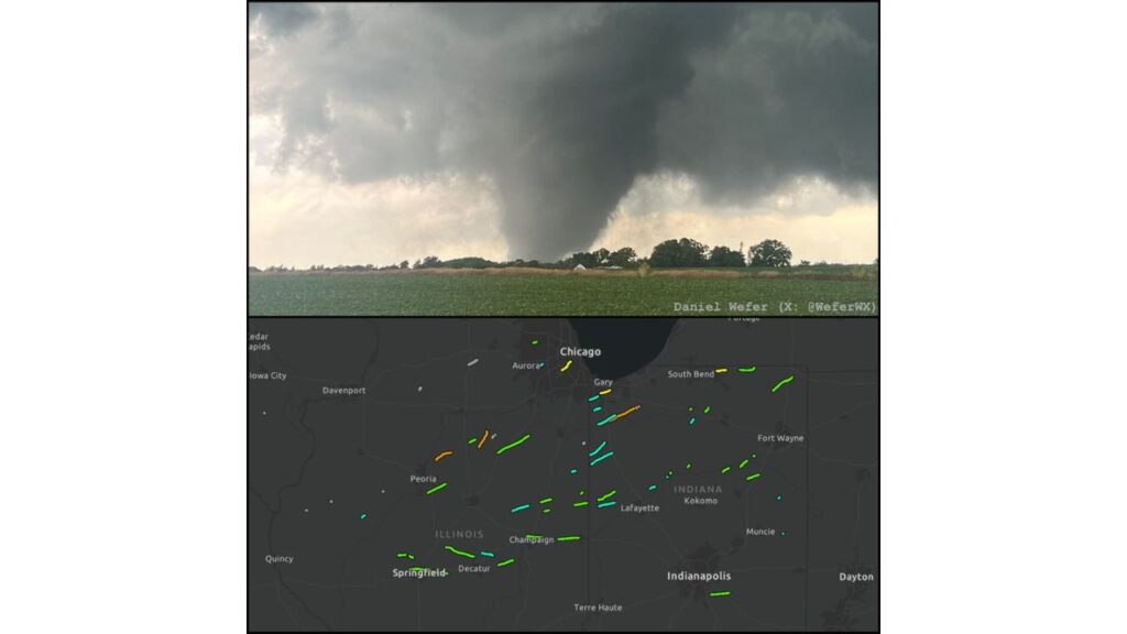
Tornado Tracks Stretched From Springfield to Fort Wayne
A map of tornado tracks from the outbreak shows paths scattered across a wide area, including near:
| State | Areas Near Tornado Tracks |
|---|---|
| Illinois | Peoria, Washburn, Streator, Aurora, Chicago area, Champaign, Decatur, Springfield |
| Indiana | Gary, Kouts, South Bend, Lafayette, Kokomo, Fort Wayne, Muncie, Indianapolis area |
Several of the longer, more intense tracks were concentrated across north-central Illinois and northwest Indiana.
What the Breakdown Will Explore
The upcoming analysis will dig into the meteorology behind the event, including:
- How the eastern supercells were able to form and intensify so quickly
- Why the western storms struggled despite getting the early attention
- Why the tornadoes were so visible, even with a wind profile that did not obviously favor it
- Other key atmospheric ingredients behind the outbreak
Why Tornado Visibility Matters
Many tornadoes are wrapped in rain or hidden by low clouds, making them hard to see. On June 11, many of the tornadoes were highly visible, which helped chasers and spotters document them and allowed residents to see them coming.
Chasers Asked to Share Footage
The forecaster behind the breakdown is asking storm chasers who captured video or photos from the outbreak to share them for the project. Their footage could help piece together a clearer picture of how the tornadoes developed.
A Dramatic Image From the Outbreak
One photo from the event, taken by storm chaser Daniel Wefer, shows a large, dark tornado dropping from a massive storm cloud over open farmland, with trees and a farm building in the foreground. The image captures the power of the storms that day.
Lessons for Future Severe Weather Days
Events like this show how difficult it can be to predict exactly where the strongest storms will form. Even experienced chasers can focus on one area while another region becomes the main threat.
Tornado Safety Reminders
- Have multiple ways to receive warnings
- Know your safe place, such as a basement or interior room
- Don’t wait to see a tornado before taking shelter
- Stay informed even if storms first form far away
Outlook: Analysis Coming Soon
The full breakdown is expected to offer new insights into one of the most interesting tornado outbreaks of 2026 in the Midwest.
Stay with Bchssreport.com for the latest updates on this story.
About The Author
