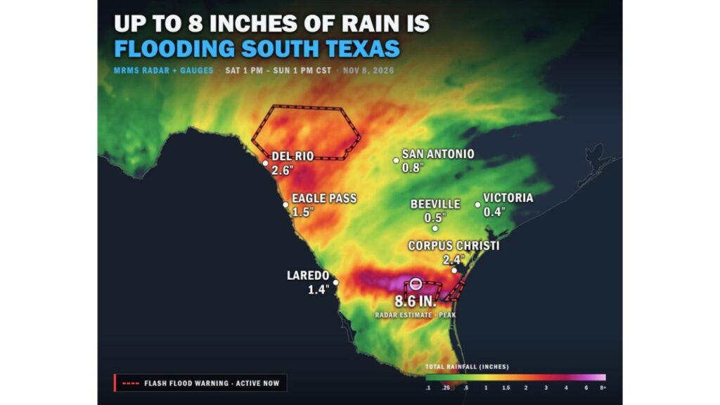
Kingsville Area of South Texas Floods as Up to 8.6 Inches of Rain Falls in 24 Hours, While a Flash Flood Warning Covers the Hill Country Near Del Rio
KINGSVILLE, TEXAS — Heavy rain has soaked parts of South Texas, with up to 8.6 inches falling in some areas from Saturday afternoon into Sunday, November 8, 2026. Flash flooding was ongoing near Kingsville, and a Flash Flood Warning covered part of the Hill Country until 8 p.m. Sunday.
Rainfall Totals From Saturday Afternoon to Sunday Afternoon
Estimates from radar and rain gauges for the 24 hours from 1 p.m. CST Saturday to 1 p.m. CST Sunday show:
| Location | 24-Hour Rainfall |
|---|---|
| Area west of Corpus Christi near Kingsville | 8.6 inches (radar estimate peak) |
| Del Rio | 2.6 inches |
| Corpus Christi | 2.4 inches |
| Eagle Pass | 1.5 inches |
| Laredo | 1.4 inches |
| San Antonio | 0.8 inch |
| Beeville | 0.5 inch |
| Victoria | 0.4 inch |
Flash Flooding Ongoing Near Kingsville
The heaviest rain fell in a band west of Corpus Christi, near Kingsville, where radar estimated a peak of 8.6 inches. Flash Flood Warnings were active for the area as water covered roads and low-lying spots.
Hill Country Under Flash Flood Warning Until 8 p.m.
Another Flash Flood Warning covered a section of the Hill Country north of Del Rio, in effect until 8 p.m. Sunday. Rain totals in that area reached 2 to 4 inches, enough to cause rapid runoff in steep terrain.
Heavy Rain Band Stretched Along the Rio Grande
A long band of moderate to heavy rain also stretched along the Rio Grande, from Del Rio through Eagle Pass and toward Laredo, bringing 1.4 to 2.6 inches to those cities.
San Antonio and the Coastal Bend See Lighter Totals
Farther north and east, totals were much lighter. San Antonio picked up less than an inch, while Beeville and Victoria recorded about half an inch or less.
Why South Texas Is Getting So Much Rain
A low-pressure system moving through Mexico has been pulling deep Gulf of Mexico moisture into South Texas. Storms repeatedly forming over the same areas allowed rain to pile up quickly in some spots.
Forecasts Warned of Even Higher Totals
Earlier forecasts had warned that some areas could see 6 to 12 inches by Monday evening, with significant flash flooding possible. Rain was still expected to continue in parts of the region.
Dangers of Flash Flooding in South Texas
South Texas flash floods can be especially dangerous because of:
- Flat terrain where water spreads quickly across roads
- Low-water crossings that can fill without warning
- Clay soils that do not absorb water well
- Nighttime flooding that makes water depth hard to judge
Flood Safety Reminders
- Turn around, don’t drown at flooded roads
- Never drive into moving water
- Stay away from creeks and drainage ditches
- Move to higher ground if water rises near your home
- Keep weather alerts on for new warnings
Outlook: More Rain Possible Through Monday
Additional rounds of rain are possible through Monday, which could worsen flooding in areas already saturated. Residents across South Texas should stay alert for updates.
Stay with Bchssreport.com for the latest updates on this story.
About The Author
