
National Hurricane Center Highlights the Southwestern Gulf With a 20 Percent Chance of Tropical Development Over the Next Seven Days
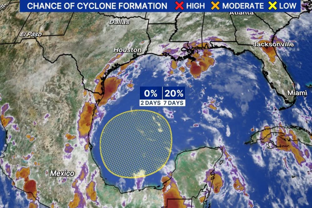
Gulf Coast – The tropics are showing signs of life again. The National Hurricane Center has highlighted an area over the southwestern Gulf where a tropical system could slowly try to develop over the coming days. The chance of formation is currently 0 percent over the next 2 days and 20 percent over the next 7 days. Any development is expected to be slow as the system drifts over the warm waters of the southwestern Gulf.
Where Forecasters Are Watching
The highlighted area covers a broad region of the southwestern Gulf, located off the coast of eastern Mexico and north of the Bay of Campeche. The zone sits west of the Yucatán Peninsula and well south of the Texas and Louisiana coastlines.
Satellite images show scattered clouds and showers across the region, along with pockets of thunderstorms near the Mexican coast and across parts of the Gulf. At this point, the activity is disorganized, with no clear center of circulation.
What a 20 Percent Chance Means
The National Hurricane Center uses a simple system to show the chances of tropical development. A low chance means development is possible but not likely, a medium chance suggests a better setup for development, and a high chance means a tropical depression or storm is likely to form.
The current outlook falls in the low category, with a 20 percent chance of formation over the next week. That means most likely nothing significant will develop, but forecasters are watching closely because conditions could become more favorable over time.
Slow Development Expected
If anything does try to form, development is expected to be slow. The system is forecast to drift over the southwestern Gulf rather than move quickly in one direction. Slow-moving systems can sometimes take extra time to organize, but they also have more time over warm water, which can help them strengthen if other conditions allow.
Signals Have Been Building
This area did not come out of nowhere. Forecasters have been keeping an eye on the Gulf for the second week of October, as several ingredients have been lining up. Those include an old frontal boundary lingering over the Gulf, moisture from the eastern Pacific crossing over into the region, and the Central American Gyre, a broad area of low pressure that often forms near Central America in the fall and can help spark tropical development.
October is also historically a month when the Gulf and western Caribbean become hot spots for storm formation, as tropical activity shifts closer to the United States late in the season.
Warm Gulf Waters
The waters of the Gulf remain warm this time of year, which provides energy for any system that tries to develop. However, warm water alone is not enough. A system also needs low wind shear, plenty of moisture, and enough time to organize. Forecasters will be watching whether these conditions come together over the next several days.
Who Should Pay Attention?
At this time, there is no immediate threat to land. However, people living along the Gulf Coast, including Texas, Louisiana, Mississippi, Alabama, and Florida, as well as eastern Mexico, should keep an eye on the forecast. Even if a named storm does not form, a slow-moving area of low pressure in the Gulf could still bring heavy rain, rough surf, and rip currents to nearby coastlines.
Too Early to Know Direction
Because the system has not formed yet, it is too early to say where it might go if it does develop. Steering currents in the Gulf can be weak in October, which could keep the system meandering for a while. Forecasters will have a much better idea of any potential track once a center of circulation forms.
Hurricane Season Is Still Active
Although many people are thinking about fall, hurricane season continues through November 30. October has produced many strong storms over the years, especially in the Gulf and Caribbean. Residents along the coast should take this time to review hurricane plans, check emergency supplies, and make sure they know their evacuation zones.
Stay Tuned for Updates
Forecasters will be monitoring this area around the clock and will provide updates as the situation evolves. Residents should check back regularly for the latest information on the southwestern Gulf and any changes in development chances.
For more tropical weather updates and hurricane season coverage, stay with bchssreport.com.