Maryland and the Mid-Atlantic Could See Rain Late Next Week as Deep Trough Heads East and a Possible Coastal Storm Forms Off the Southeast, While Election Day Stays Dry
BALTIMORE, MARYLAND — After a long stretch of dry weather, rain may finally return to Baltimore and the Mid-Atlantic late next week. A deep upper-level trough is expected to push toward the East Coast, and a coastal storm could develop ahead of it, possibly becoming a hybrid storm or a nor’easter.
The good news for voters: Election Day, Tuesday, November 3, still looks dry at this point.
What Is Driving the Late-Week Storm Threat
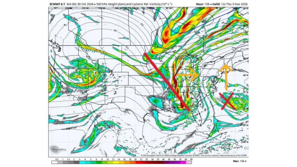
The main player is a deep upper-level trough with a negative tilt, a setup that often helps storms strengthen as they approach the coast. Forecast maps for 7 a.m. EST Thursday, November 5, show this trough stretching from the Upper Midwest south through the Ohio and Tennessee Valleys and down toward the Gulf Coast and Florida Panhandle.
Trough Axis Stretches From the Upper Midwest to the Gulf Coast
| Feature | Location Thursday Morning, November 5 |
|---|---|
| Upper-level trough axis | Upper Midwest through the Ohio Valley to the Gulf Coast |
| Strongest energy | Ohio Valley, Appalachians and Southeast |
| Expected movement | East toward the Mid-Atlantic and East Coast |
| Possible coastal storm | Off the Southeast coast, moving north |
Possible Coastal Storm Developing Off the Southeast Coast
Ahead of the trough, another coastal storm could form off the Southeast coast, east of the Carolinas. Forecast arrows show this system potentially moving north along the coast as the trough pushes east.
Hybrid Storm or Nor’easter? Forecasters Not Sure Yet
It is still unclear what type of storm this will become. It could turn into:
- A hybrid storm, with features of both tropical and non-tropical systems
- A classic nor’easter, tracking up the East Coast with rain and wind
The final outcome will depend on how the coastal low and the incoming trough interact.
Rain Likely Around Baltimore After a Long Dry Stretch
Whatever form the storm takes, forecasters say it will probably bring rain to the Baltimore area. That would be welcome news after a long period of dry weather across the region.
Election Day Looks Dry for Now
At this point, Election Day, Tuesday, November 3, is expected to stay dry in the Baltimore area, with the storm threat holding off until later in the week.
Other Areas That Could Be Affected
If the storm develops and moves up the coast, impacts could extend beyond Maryland to other parts of the East Coast, including:
- Virginia and Washington, D.C.
- Delaware and New Jersey
- Coastal Carolinas
The exact track will determine who sees the heaviest rain and strongest winds.
Potential Impacts If the Storm Comes Together
- Soaking rain that could ease dry conditions
- Gusty winds, especially near the coast
- Rough surf and coastal flooding concerns if the storm strengthens near shore
- Travel delays late in the week
Forecast Confidence Still Limited
The setup is still several days away, and the forecast could change. Small shifts in the trough’s timing or the coastal low’s track could mean the difference between a soaking rain and a near miss.
Outlook: Stay Tuned as the Week Unfolds
Residents across Maryland and the Mid-Atlantic should keep an eye on forecast updates through early next week as details come into focus.
Stay with Bchssreport.com for the latest updates on this story.
About The Author
