
Lingering Gulf Low Pumps Extra Rain Into Texas, Louisiana, Alabama, and the Carolinas Through Next Week as El Nino Pattern Takes Shape This Fall
MOBILE, AL — An interesting weather pattern is setting up across the Gulf and the Southeast over the next week or so. Ensemble guidance shows low pressure lingering in the lower Gulf through the week, pumping moisture northeast and adding several days of extra rain chances. The setup is a clear sign of how El Nino tends to influence fall and winter weather in the South. Tropical development chances remain very low, and no rain forecast is considered solid yet.
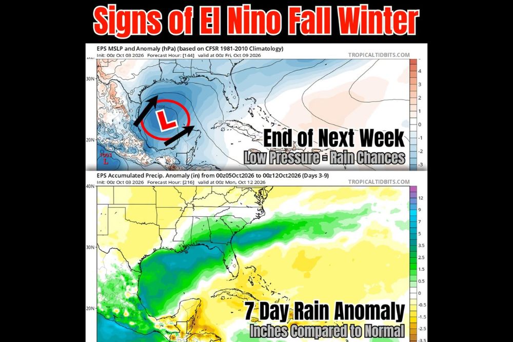
Low Pressure Lingers in the Lower Gulf Through End of Next Week
The European ensemble shows an area of low pressure sitting over the lower Gulf through the end of next week, valid around Friday, October 9. The low is centered over the central and southern Gulf, with lower-than-normal pressure spreading across much of the basin.
Arrows on the pressure map show moisture being pushed northeast from the low toward the Gulf Coast. A separate weaker low near 1003 millibars is also shown near the southwestern Gulf along the Mexican coast.
Seven-Day Rain Anomaly Highlights the Gulf Coast and Southeast
Rainfall projections from October 5 through October 12 show above-normal rain across the northern and western Gulf and much of the Gulf Coast. The wetter-than-normal zone covers coastal Texas, Louisiana, Mississippi, Alabama, and the Florida Panhandle.
That band of extra rain stretches northeast into Georgia, South Carolina, and the North Carolina coast before extending offshore into the Atlantic. Some areas in this zone show totals running roughly 2.5 to 5 inches above normal.
Florida Peninsula and Caribbean Lean Drier Than Normal
Much of the Florida peninsula falls outside the wettest zone, with near to below-normal rain shown for the week. Drier-than-normal conditions are also indicated across parts of the Caribbean and the Yucatan Peninsula.
Areas farther inland across the central and northern United States show little change from normal rainfall. The main signal for extra rain stays focused along the Gulf Coast and the Southeast coastline.
Pattern Reflects Typical El Nino Influence in Fall and Winter
A lingering Gulf low sending moisture northeast across the South is a classic sign of El Nino influence during fall and winter. That pattern often leads to wetter conditions along the Gulf Coast and southeastern states.
This setup may become more common in the months ahead as the season progresses. Residents across the South could see more frequent rain chances if the pattern continues to develop.
Tropical Chances Stay Very Low as Rain Totals Remain Uncertain
Tropical development chances from the Gulf low remain very low at this time. Only a few ensemble members continue to show any tropical development, while most do not.
Rain chances are clearly present, but it is not yet certain where or how much rain will actually fall. Residents along the Gulf Coast and in the Southeast should keep checking updated forecasts through the week as details become clearer.
Stay with bchssreport.com for the latest weather updates and local forecast coverage.