
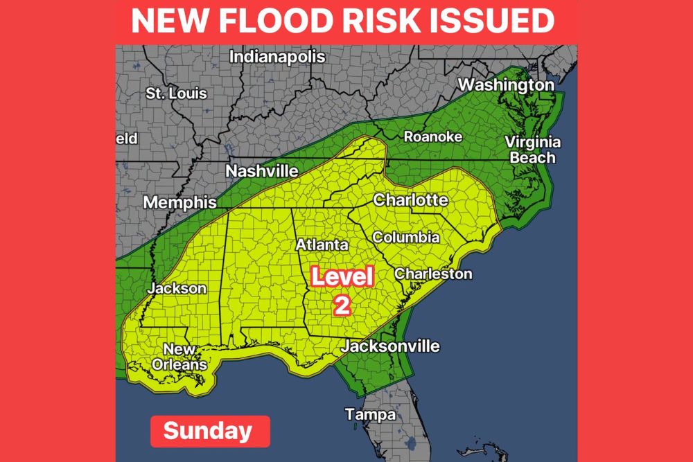
Level 2 Flood Risk Issued Across the Southeast for Sunday as a Weekend Soaker Threatens 2 to 4 Inches of Rain and Isolated Flash Flooding
Southeast – A Level 2 of 4 flood risk is now in place across a large part of the Southeast for Sunday, as a soaking rain event takes aim at millions of people from Louisiana to the Carolinas. A widespread 2 to 4 inches of rain looks like a good baseline for many areas, with some locations potentially exceeding those amounts depending on where the heaviest bands of rain set up. That much rain could be enough to cause isolated flash flooding, especially in places that see repeated rounds of heavy downpours.
Where the Level 2 Risk Is in Place
The Level 2 flood risk covers a broad stretch of the Deep South and Southeast. It includes southeastern Louisiana, including New Orleans, much of Mississippi, including Jackson, and nearly all of Alabama. The risk area also covers most of Georgia, including Atlanta, along with most of South Carolina, including Columbia and Charleston.
In North Carolina, the Level 2 risk includes the Charlotte area and stretches across much of the central and southern parts of the state, reaching into the mountains and foothills. It also extends into parts of eastern Tennessee and the far southwestern corner of Virginia.
Level 1 Risk Surrounds the Main Threat Zone
A Level 1 of 4 flood risk surrounds the main threat area. This includes areas near Memphis and Nashville in Tennessee, along with Roanoke, Virginia Beach, and parts of the Washington, D.C. region. In Florida, the Level 1 risk extends across the northeastern part of the state, including Jacksonville. Areas farther south, including Tampa, sit just outside the risk zone.
In these Level 1 areas, flooding is still possible but is expected to be more isolated.
Understanding the Flood Risk Levels
Flood risk outlooks use a four-level scale. Level 1 (Marginal) means isolated flash flooding is possible, while Level 2 (Slight) means scattered flash flooding is possible. Level 3 (Moderate) indicates numerous flash flood events are likely, and Level 4 (High) is reserved for widespread, severe flooding situations.
A Level 2 risk means residents should stay alert, especially in areas that are prone to flooding or where heavy rain falls over the same spots for a long period of time.
How Much Rain Could Fall?
A widespread 2 to 4 inches of rain is expected across many parts of the risk area. However, some locations could see more than 4 inches, particularly where heavy rain bands set up and stall. These bands can be narrow, meaning one town could get much heavier rain than a neighboring community just a few miles away.
Forecasters are continuing to track the corridor of heaviest rain, and the exact placement could shift as Sunday gets closer.
What Is Causing the Heavy Rain?
The rain is tied to a slow-moving cold front stalling across the Southeast, combined with deep moisture flowing in from the Gulf. Moisture associated with the remnants of Hurricane Polo, which has already fueled heavy rain across Texas and the Southern Plains this week, is also helping add fuel to the system. When a front stalls over the same area while moisture keeps streaming in, it can lead to repeated rounds of heavy rain and higher rainfall totals.
Flash Flooding Concerns
The biggest concern with this rain event is flash flooding. Areas most at risk include low-lying neighborhoods, poor drainage areas, urban streets, and spots near creeks and small streams. Cities like Atlanta, Charlotte, Columbia, Jackson, and New Orleans can see water build up quickly on roads and underpasses during heavy downpours.
In the mountains of North Carolina and nearby areas, steep terrain can cause rainwater to run off quickly into streams, leading to rapid rises in water levels.
Rain Could Be Beneficial Too
While flooding is a concern, many areas across the Southeast have been dealing with dry conditions, so the rain will also be welcome news for lawns, gardens, farms, and water supplies. The challenge is that dry, hardened ground does not always absorb heavy rain quickly, which can lead to more runoff at first.
Weekend Plans Could Be Affected
With the heaviest rain expected on Sunday, many weekend events across the Southeast could be impacted. Football games, tailgates, outdoor weddings, festivals, and youth sports may need backup plans or covered areas. Travelers driving along major highways such as I-20, I-85, I-75, I-65, I-26, and I-10 should be prepared for heavy rain, reduced visibility, and slower travel.
Turn Around, Don’t Drown
The most important safety message is to never drive through flooded roads. Just 6 inches of moving water can cause drivers to lose control, and 12 inches can carry away many vehicles. Floodwater can also hide washed-out roads and debris. If a road is covered with water, turn around and find another route.
How to Prepare Now
Before the rain arrives, residents should clear gutters and storm drains, move vehicles away from flood-prone areas, and make sure emergency alerts are turned on. People living in low-lying areas should know where they would go if water begins to rise and should keep phones charged.
Stay Tuned for Updates
The exact location of the heaviest rain could still change. Residents across the Southeast should keep an eye on forecast updates through the weekend.
For more Southeast weather updates and flood alerts, stay with bchssreport.com.