Iowa, Illinois, Indiana, Kentucky and Tennessee in Line for Widespread Rain Tuesday, November 3, as 993 mb Low Tracks From the Plains Into the Midwest
PEORIA, ILLINOIS — A widespread rain system is shaping up for early next week, with a low pressure system expected to move across the Plains and into the Midwest by Tuesday morning, November 3, spreading rain from Nebraska and Iowa all the way to Tennessee, Alabama and Georgia.
The good news: severe storms are not currently expected with this system, though forecasters will keep watching for any changes.
Timing: Rain Expected Across the Region by 7 a.m. EST Tuesday, November 3
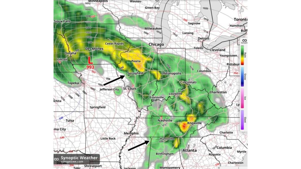
Simulated radar for 7 a.m. EST on Tuesday, November 3, shows a large shield of rain already in place across much of the central and eastern United States by the morning commute.
Storm Center: 993 mb Low Over Northern Missouri
The heart of the system is a 993-millibar low pressure center positioned over northern Missouri, between Lincoln, Nebraska, and Jefferson City, Missouri.
Rain wraps around the north side of the low and stretches in a long band to the southeast, following the system’s path toward the Ohio and Tennessee Valleys.
Northern Rain Shield: Nebraska, Iowa, South Dakota and Southern Minnesota
The northern edge of the system brings rain to:
- Omaha and Lincoln, Nebraska
- Des Moines and Cedar Rapids, Iowa
- Sioux Falls, South Dakota
- Parts of southern Minnesota near Minneapolis
Some heavier pockets show up across western Iowa and near Omaha.
Heaviest Midwest Rain: Peoria, Springfield and Indianapolis
Some of the most intense rain on the simulated radar lines up across central Illinois and Indiana:
| Area | Rain Intensity |
|---|---|
| Peoria, Illinois | Heavy rain |
| Springfield, Illinois | Moderate to heavy rain |
| Indianapolis, Indiana | Moderate to heavy rain |
| St. Louis, Missouri | Light to moderate rain |
| Evansville, Indiana | Light to moderate rain |
Chicago sits near the northern edge of the rain, while Milwaukee and most of Michigan stay mostly dry at this time.
Ohio Valley Rain: Cincinnati, Louisville, Columbus and Charleston
Rain also spreads across the Ohio Valley, including:
- Cincinnati and Columbus, Ohio
- Louisville, Kentucky
- Charleston, West Virginia
Pockets of heavier rain appear around Louisville and parts of eastern Kentucky.
Tennessee Valley Sees Strongest Downpours Near Knoxville
The most intense rain on the entire map shows up in eastern Tennessee, where heavy downpours are highlighted near Knoxville. Rain also covers Nashville and stretches south into:
- Huntsville and Birmingham, Alabama
- Northern Georgia near Atlanta
Areas Staying Mostly Dry Tuesday Morning
Outside the main rain shield, several areas stay mostly dry at 7 a.m., including:
- Michigan, including Detroit and Lansing
- Northern Ohio, including Cleveland and Toledo
- Kansas, Oklahoma and Arkansas
- The Carolinas
Severe Weather Not Expected, but Forecasters Continue to Monitor
At this time, severe thunderstorms are not expected with the system. However, forecasters say they will continue to monitor the potential in case conditions change as the storm gets closer.
Impacts: Wet Commutes and a Soggy Start to November
Widespread rain on a weekday morning could bring:
- Slower commutes and wet roads in cities like Peoria, Indianapolis, Louisville and Knoxville
- Ponding on roadways in heavier downpours
- Delays for any remaining outdoor or farm work
Outlook: Watch for Forecast Updates Through the Weekend
Because this forecast is several days out, the exact track and timing of the low could still shift. Residents from the Plains to the Southeast should check updated forecasts through the weekend.
Stay with Bchssreport.com for the latest updates on this story.
About The Author
