
Hurricane Polo Remnants and a Slow-Moving Cool Front Could Bring Heavy Rain and Flash Flooding to Texas as October Begins
Houston, Texas – Texans may want to keep a close eye on the forecast this week. A classic El Niño fall flood pattern is developing, with heavy rain and flash flooding possible somewhere in the state as tropical moisture, the remnants of Hurricane Polo, and a cool front come together. While the setup looks concerning, pinpointing exactly where the heaviest rain will fall is still a challenge at this point.
How the Setup Comes Together
The basic ingredients are lining up for a soaking. A slow-moving storm system is expected to pull in a large plume of tropical moisture, scoop up what is left of Hurricane Polo, and merge it with an incoming cool front over Texas.
That cool front is expected to act as a focusing point for heavy rainfall. Because the front will line up parallel to the winds higher in the atmosphere, training thunderstorms are possible. Training happens when storms repeatedly move over the same areas, one after another, which can quickly pile up rainfall totals and lead to flash flooding.
Rain Chances Build Through the Week in Houston
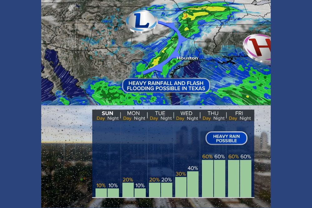
For the Houston area, the week starts off mostly dry before rain chances steadily climb. Sunday brings just a 10 percent chance of rain during the day and night. Monday rises to 20 percent during the day before dropping to 10 percent at night, and Tuesday holds at 20 percent through both the day and night.
Rain chances increase further on Wednesday, reaching 30 percent during the day and 40 percent Wednesday night. The wettest stretch looks to arrive late in the week, with rain chances jumping to 60 percent Thursday and continuing at 60 percent through Friday day and night, when heavy rain is possible.
Peak Rain Expected Thursday Through Saturday
Locally, rain chances are expected to peak sometime in the Thursday through Saturday window. That is when the front, tropical moisture, and Polo’s leftover energy are most likely to combine over Southeast Texas.
Rainfall Totals Still Uncertain
It is still too early to say how much rain will fall. Rainfall totals remain uncertain, and the exact track of the storm system and the position of the front will decide which communities see the heaviest downpours. Small shifts in the setup could mean big differences in who gets the most rain.
Get Ready for Possible Flooding
Residents in flood-prone areas should start preparing now. Clearing storm drains, checking gutters, and keeping an eye on low-lying streets can help reduce problems if heavy rain develops. Drivers should never attempt to cross flooded roads, since even shallow moving water can sweep a vehicle away.
For more Texas weather updates and flood alerts, stay with bchssreport.com.