
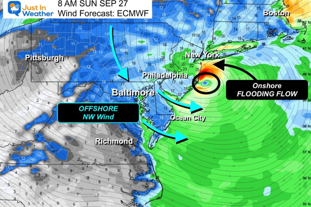
Nor’easter Stalls Near the New Jersey Coast and Sends a Second Surge of Rain Into Central Maryland and the Mid-Atlantic on Sunday
Maryland – For much of the Mid-Atlantic, Sunday may feel like Saturday on repeat. The nor’easter that has been churning off the coast is expected to stall near the New Jersey coast, sending a second surge of rain back into Central Maryland and surrounding areas. While the storm is weakening, it will continue to bring rain, gusty winds, and changing water levels across the region throughout the day.
Worst Conditions for Northern New Jersey, New York City, and Long Island
The hardest-hit areas from this storm are expected to be Northern New Jersey, New York City, and southern Long Island, where the heaviest rain, strongest winds, and highest flooding threat are focused. Residents in these areas should stay alert for coastal flooding, downed trees, and power outages.
Low Pressure Moving West Toward the New Jersey Coast
The area of low pressure is tracking westward overnight and could reach the New Jersey coast by daybreak Sunday. From there, the storm is expected to spend much of Sunday making a small loop, drifting southwest before turning back toward the Northeast.
The exact path is hard to pin down. The storm is likely to stay closer to New Jersey, but it could dip near the Delaware coast before pulling away again later in the day.
Second Surge of Rain Returns to Central Maryland
As the storm loops, it will send a second surge of rain back into Central Maryland during the morning. Rain is expected to become steadier by midday and into the afternoon, pushing farther inland later in the day.
Areas closer to the Chesapeake Bay, the Eastern Shore, Delaware, and South Jersey are likely to see the heaviest rain, while places farther west, including Frederick, Hagerstown, and parts of northern Virginia, may see lighter rain with misty showers at times.
Winds Turn Offshore From the Northwest
Winds are expected to shift offshore, coming from the northwest. This change could push water across the Chesapeake Bay toward the Eastern Shore, which may cause some water to pile up in spots there. At the same time, the offshore flow should help water drain out of other areas.
The winds will not be as strong as earlier in the storm since the system is weakening, but gusts could still top 30 mph, especially near the water.
Lower Water Levels Along the Delmarva Coast
The offshore winds should help keep water levels lower along the Delmarva coast, easing concerns about coastal flooding there. The shifting winds and lingering swells may also bring out more surfers looking to take advantage of the waves, though anyone heading into the water should be careful of strong rip currents.
Stay Prepared Through Sunday
With steady rain returning and gusty winds continuing, residents across the Mid-Atlantic should plan for wet roads, possible ponding in low-lying areas, and slower travel. Securing loose outdoor items and keeping an eye on local alerts can help everyone stay safe until the storm finally moves away.
For more Maryland and Mid-Atlantic weather updates and storm alerts, stay with bchssreport.com.