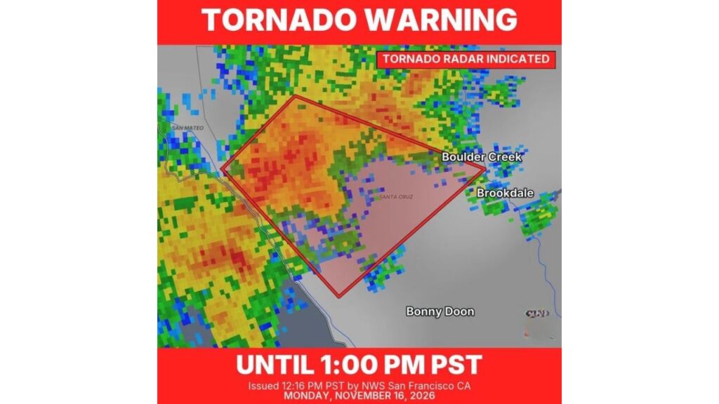
Rare Tornado Warning Issued for Santa Cruz County, California as Radar Detects Rotation Near Boulder Creek After At Least Three Waterspouts Form Offshore
SANTA CRUZ COUNTY, CALIFORNIA — A rare tornado warning was issued for part of Santa Cruz County, California, on Monday, November 16, 2026, after radar detected rotation in a storm moving through the Santa Cruz Mountains.
The National Weather Service in San Francisco issued the warning at 12:16 p.m. PST, in effect until 1 p.m. PST. The same stormy setup had already produced at least three waterspouts earlier in the day.
Tornado Warning Details
| Detail | Information |
|---|---|
| Issued by | National Weather Service, San Francisco |
| Issued | 12:16 p.m. PST Monday, November 16 |
| Expired | 1 p.m. PST |
| Type | Radar-indicated tornado |
| Area | Northern and central Santa Cruz County |
| Earlier activity | At least three waterspouts |
Communities Inside or Near the Warning Area
The warning box covered a section of the Santa Cruz Mountains, stretching from near the San Mateo County line toward the San Lorenzo Valley. Communities in or near the warned area included:
- Boulder Creek
- Brookdale
- Areas north of Bonny Doon
- Rural mountain areas in northern Santa Cruz County
What “Radar Indicated” Means
A radar-indicated tornado warning means forecasters saw rotation in the storm on radar that could produce a tornado. It does not mean a tornado had been confirmed on the ground. Even so, residents in the warning area were urged to take shelter immediately.
Waterspouts Spotted Earlier in the Day
The atmosphere along the Central California coast was already active before the warning, producing at least three waterspouts over the ocean. A waterspout is a rotating column of air over water, and some can move onshore and act like weak tornadoes.
How Rare Is a Tornado Warning in Santa Cruz?
Tornado warnings are very uncommon along the California coast, but they are not unheard of. Cold, unstable air moving over the relatively warm Pacific Ocean during strong fall and winter storms can create brief rotating storms and waterspouts.
Part of an Active Pacific Storm Pattern
The warning came as a series of strong Pacific storms moves into California, bringing:
- Heavy rain along the coast
- Huge surf, with sets up to 50 feet at Bay Area breaks over the weekend
- Heavy Sierra snow, with some peaks forecast to see feet of snow by Thanksgiving
- An atmospheric river expected to bring 2 to 3.5 inches of rain from the Bay Area to San Luis Obispo on Wednesday
Tornado Safety Tips for California Residents
- Move to an interior room on the lowest floor, away from windows
- Avoid mobile homes and vehicles during a warning
- Stay away from beaches when waterspouts are reported
- Keep phone alerts on for new warnings
- Watch for downed trees and power lines in the mountains after storms
Damage Reports Still Being Reviewed
It was not immediately clear whether a tornado touched down. The National Weather Service typically reviews storm reports and may survey any damage before confirming a tornado.
Outlook: More Stormy Weather Ahead
With another round of heavy rain and gusty winds headed for the Bay Area and Central Coast this week, more thunderstorms, waterspouts and possibly brief rotating storms cannot be ruled out.
Stay with Bchssreport.com for the latest updates on this story.
About The Author
