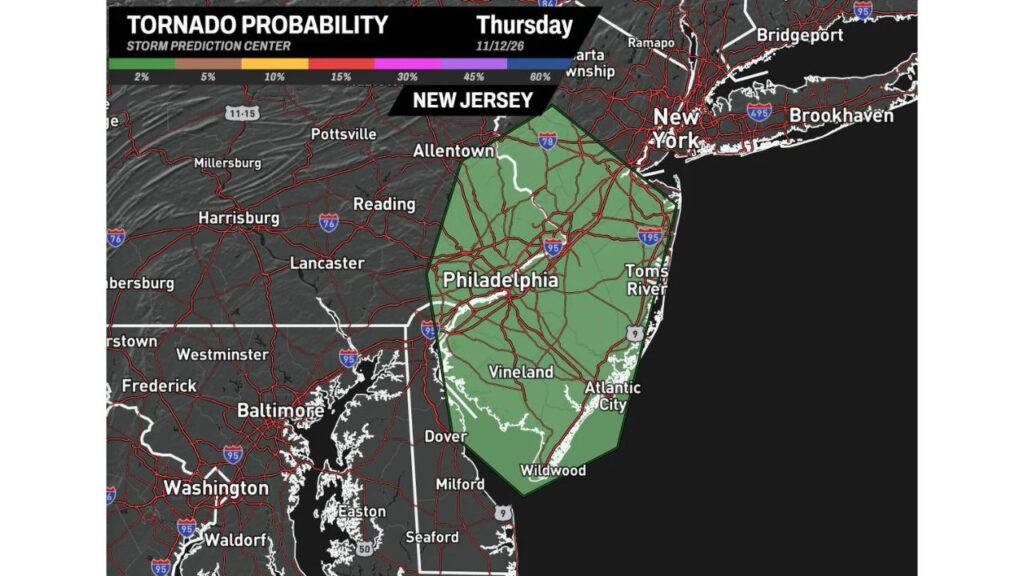
New Jersey Could See Its First Confirmed November or December Tornado Since 1994 as a 2% Tornado Risk Covers Philadelphia, Toms River and Atlantic City Thursday
TRENTON, NEW JERSEY — New Jersey has not had a confirmed tornado in November or December since 1994. That streak could come to an end on Thursday, November 12, 2026.
The Storm Prediction Center has outlined a 2% tornado probability across most of New Jersey, along with southeast Pennsylvania and northern Delaware, as a low-pressure system brings rain and storms to the region.
A Rare Late-Season Tornado Threat
| Detail | Information |
|---|---|
| Date | Thursday, November 12, 2026 |
| Tornado probability | 2% within 25 miles of any point |
| Last confirmed NJ tornado in Nov. or Dec. | 1994 |
| Gap | 32 years |
Areas Inside the Tornado Risk Zone
The outlined area covers much of central and southern New Jersey, plus nearby parts of Pennsylvania and Delaware:
| Area | Cities and Towns |
|---|---|
| Central New Jersey | Areas along I-95 and I-195 |
| Jersey Shore | Toms River, Atlantic City and Wildwood |
| South Jersey | Vineland and surrounding communities |
| Southeast Pennsylvania | Philadelphia and areas near Allentown |
| Delaware | Areas near Dover |
Cities like New York, Baltimore and Washington, D.C. are outside the risk zone.
Why a November Tornado Would Be So Rare in New Jersey
Most tornadoes in New Jersey happen during the warmer months, from late spring through summer. By November, the atmosphere is usually too cold and stable to support rotating storms. A confirmed tornado this late in the year would mark a rare event for the state.
What a 2% Tornado Risk Means
A 2% tornado risk is the lowest level typically shown on tornado outlooks. It means:
- Most areas will not see a tornado
- A brief, weak tornado is possible in a few storms
- Storms that do rotate may be short-lived
Still, even a weak tornado can damage trees, roofs and power lines.
What’s Driving the Storms
A low-pressure system moving into the Northeast is pulling warm, moist air up the coast. Combined with changing winds at different heights, that setup could allow a few storms to briefly rotate on Thursday afternoon.
Heavy Rain Also Expected
The same system is bringing soaking rain to the region, with:
- 0.5 to 1.5 inches across much of New Jersey and Philadelphia
- Isolated totals near 2 inches along the coast
- Rain continuing into Friday evening
Possible Hazards Thursday
- A brief tornado
- Gusty winds
- Heavy downpours and ponding on roads
- Slow commutes on the Garden State Parkway, New Jersey Turnpike and I-95
Tornado Safety Tips
- Keep phone alerts on, especially during the afternoon
- Know your safe place, such as a basement or interior room
- Get indoors quickly if a warning is issued
- Avoid driving into heavy storms
Outlook: Cold Air Follows
After the storms move out, colder air will sweep into New Jersey and the Northeast, bringing gusty winds and chilly temperatures through the weekend.
Stay with Bchssreport.com for the latest updates on this story.
About The Author
