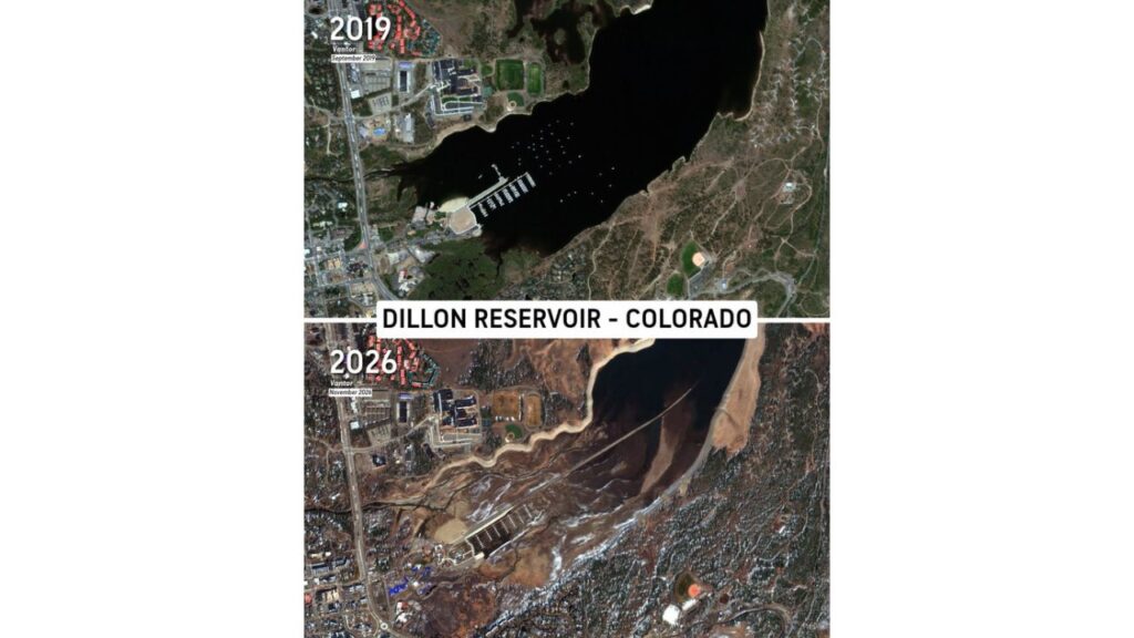
Dillon Reservoir in Colorado Shrinks Dramatically in Satellite Images From 2019 to 2026, Leaving Marina Docks on Dry Mud and Exposing Long-Hidden Old Highway 6
DILLON, COLORADO — New satellite images reveal just how much water has disappeared from Dillon Reservoir in Colorado. A side-by-side comparison from September 2019 and November 2026 shows a dramatic drop in water levels, exposing parts of old Highway 6 that are usually hidden underwater.
Then vs. Now: A Striking Comparison
| Feature | September 2019 | November 2026 |
|---|---|---|
| Water coverage | Reservoir filled the basin | Large areas of exposed lakebed |
| Marina docks | Floating in deep water | Sitting on mud and dry ground |
| Boats | Dozens moored across the bay | Bay largely empty |
| Old Highway 6 | Hidden beneath the water | Visible across the dry lakebed |
| Shoreline | Close to town and parks | Pulled back significantly |
2019: A Full Reservoir and a Busy Marina
The 2019 image shows Dillon Reservoir full and dark blue, reaching right up to the edge of town. Dozens of boats are moored in the bay, and the marina docks sit in deep water next to the shoreline.
2026: Docks Stranded on Exposed Lakebed
By November 2026, the scene looks very different. Much of the bay has drained away, leaving:
- Marina docks resting on mud and dry ground
- Wide stretches of exposed lakebed where water once stood
- A narrow channel where the reservoir has pulled back
- The remaining water pushed toward the eastern side of the basin
Old Highway 6 Reappears
One of the most striking details is the reappearance of old Highway 6. In the 2026 image, a long, straight road can be seen stretching across the dry lakebed. This section of roadway is normally submerged and only becomes visible when water levels drop very low.
Why Water Levels Are So Low
The images come after a dry stretch across much of the West, including a slow start to winter. In early November, only about 1.9% of the Lower 48 had snow on the ground, and cities like Denver had not yet recorded their first snow of the season.
Low snowpack and dry conditions can mean less runoff flowing into reservoirs like Dillon.
Relief May Be on the Way
Forecasters say a series of cold storm systems is set to move into the West, bringing heavy mountain snow to the Colorado Rockies. Some areas could see 14 to 22 inches of snow over the next week, which could eventually help refill reservoirs once that snow melts in spring.
What Low Reservoir Levels Can Mean
Shrinking reservoirs can lead to:
- Water supply concerns for communities downstream
- Fewer recreation options, including boating and fishing
- Exposed hazards like old roads, stumps and debris
- Changes to wildlife habitat around the shoreline
Tips for Visitors
- Stay off exposed lakebed areas, which can be soft and unstable
- Follow posted signs around the marina
- Respect closed areas near old roads and structures
A Visual Reminder of Western Water Challenges
The Dillon Reservoir images offer a powerful look at how quickly water levels can change in the West, and why upcoming winter snowfall matters so much for the region.
Stay with Bchssreport.com for the latest updates on this story.
About The Author
