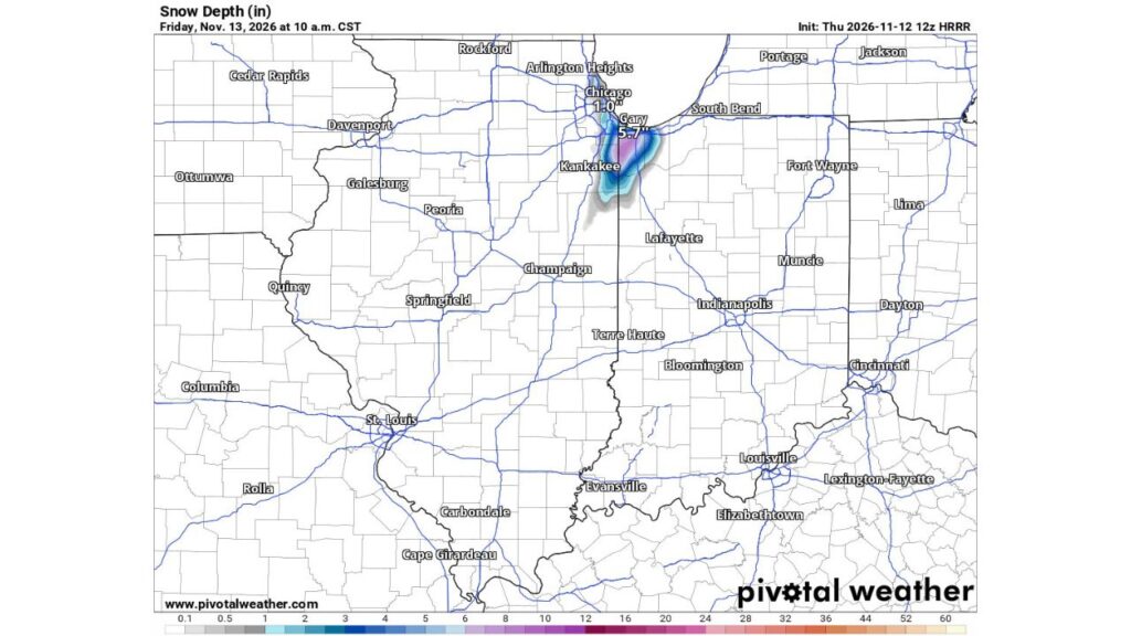
Lake County, Indiana Could See Up to 5 to 8 Inches of Lake-Effect Snow in a Worst-Case Scenario Friday Morning, but 1 to 3 Inches Is More Likely by Sunrise
GARY, INDIANA — A lake-effect snow band is expected to develop late Thursday night, November 12, 2026, and continue into Friday morning, November 13, across northwest Indiana and parts of northeast Illinois.
In the highest-end scenario, Lake County, Indiana, and areas near the Illinois-Indiana border could see 5 to 8 inches of snow. However, forecasters say 1 to 3 inches is more realistic by sunrise Friday, mainly on grass and elevated surfaces.
Two Scenarios for Friday Morning
| Scenario | Expected Snow | Where |
|---|---|---|
| Most likely | 1 to 3 inches on grassy and elevated surfaces | Northwest Indiana and the Illinois-Indiana border |
| Highest-end ceiling | 5 to 8 inches | Lake County, Indiana, and near the state line |
Timing of the Lake-Effect Band
| Time | What to Expect |
|---|---|
| Late Thursday night | Heavy band begins developing off Lake Michigan |
| Overnight into Friday morning | Peak snowfall in northwest Indiana |
| Friday morning commute | Snow-covered roads possible under the heaviest band |
| Later Friday | Snow tapers off |
High-Resolution Forecast Shows a Narrow, Heavy Band
A short-range, high-resolution forecast showing snow depth at 10 a.m. CST Friday paints a narrow band of snow stretching from Lake Michigan south into northwest Indiana and toward Kankakee, Illinois.
| Location | Snow Depth in This Forecast |
|---|---|
| Gary, Indiana area | About 5.7 inches |
| Chicago | About 1 inch |
| Band south toward Kankakee | Lighter amounts along the edges |
| Indianapolis, Lafayette and South Bend | Little to none |
This forecast already accounts for some melting during the event.
Why the Ceiling Is So High
Lake-effect snow can be extremely localized. If a single band stalls over the same spot for several hours, snow can pile up fast, sometimes at rates of 1 inch per hour or more. That is what drives the 5 to 8 inch worst-case scenario.
Why 1 to 3 Inches Is More Likely
Several factors could keep totals lower:
- Warm ground after a mild fall can melt snow as it falls
- Recent rainfall has left surfaces wet
- Lake-effect bands often shift rather than stay in one place
That is why forecasters expect most areas to see 1 to 3 inches, mainly on grassy and elevated surfaces like decks, cars and rooftops.
Possible Impacts for the Friday Commute
If the highest-end scenario plays out, drivers could face:
- Snow-covered roads Friday morning
- Slick conditions on I-65, I-80, I-90 and I-94
- Sudden drops in visibility under heavy snow bands
- Delays for the morning commute
Part of a Larger Cold Pattern
This lake-effect setup comes as colder air spreads across the Great Lakes and eastern U.S., with mountain snow in the Southern Appalachians and a low-pressure system bringing rain and some snow to the Northeast.
Winter Driving Tips
- Slow down in snow bands
- Increase following distance
- Use headlights in low visibility
- Check road conditions before leaving Friday mornin
About The Author
