Boone and the North Carolina High Country Face Two Rounds of Snow Showers Friday, With Up to 6.8 Inches on the Highest Smoky Mountain Peaks and Gusts Up to 45 MPH by Saturday
BOONE, NORTH CAROLINA — The High Country of North Carolina and the mountains along the Tennessee line are set to see their first few inches of snow this season from Friday, November 13, into early Saturday, November 14, 2026.
This is strictly a northwest flow event at high elevations, meaning lower areas will see little to nothing, and there will be no snow east of the mountains.
What Drives This Type of Snow
Northwest flow snow happens when winds blow from the northwest, carrying moisture, sometimes connected to the Great Lakes, into the Appalachian Mountains. As the air rises up the slopes, it cools and produces snow, mostly on higher, northwest-facing ridges.
The best windows for snow are Friday night and Saturday morning, when the wind direction and Great Lakes connection line up best.
Snow Timing in Boone
| Time Window | What to Expect |
|---|---|
| Friday, 3 a.m. to 10 a.m. | Snow showers develop, temps 34 to 35°, grassy coatings |
| Friday, 6 p.m. to 2 a.m. | Round 2, colder, temps falling from 33° to 30°, slick spots |
| Saturday morning | Snow tapering, windy and cold, gusts 30 to 45 mph, lows near 27° |
Hour-by-Hour Snow Chances in Boone
| Time | Chance of Snow | Temperature |
|---|---|---|
| Thursday, 9 p.m. | 19% | 38° |
| Friday, midnight | 33% | 37° |
| Friday, 3 a.m. | 51% | 35° |
| Friday, 6 a.m. | 51% | 34° |
| Friday, 9 a.m. | 41% | 34° |
| Friday, noon | 32% | 37° |
| Friday, 3 p.m. | 41% | 36° |
| Friday, 6 p.m. | 44% | 33° |
| Friday, 9 p.m. | 56% | 31° |
| Saturday, midnight | 49% | 30° |
| Saturday, 3 a.m. | 29% | 29° |
| Saturday, 6 a.m. | 29% | 27° |
How Much Snow in Boone?
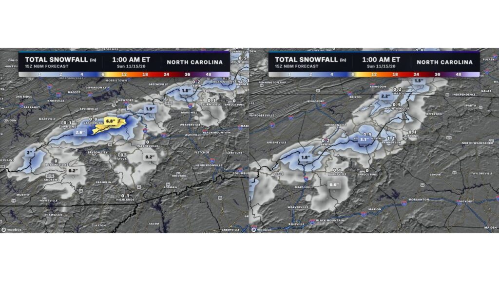
A blend of forecast models shows about 0.6 inch for Boone, generally a coating to 1 inch. The highest single model shows up to 2.2 inches, and 11 of 16 models show at least 0.1 inch.
Forecast Totals Across the Mountains Through Early Sunday
| Location | Forecast Snow |
|---|---|
| Highest Smoky Mountain peaks east of Gatlinburg | 6.8 inches |
| Roan Mountain high peaks | 3.1 inches |
| Smokies west of Gatlinburg | 2.6 inches |
| High terrain north of Mountain City | 2.2 inches |
| State line ridges west of Robbinsville | 2 inches |
| State line near I-40 | 1.9 inches |
| State line near Erwin and I-26 | 1.8 inches |
| Mount Rogers area, Virginia | 1.5 inches |
| Banner Elk | 1.1 inches |
| Gatlinburg | 0.8 inch |
| Mountain City | 0.5 inch |
| Erwin and Andrews | 0.2 inch |
| Boone and Burnsville | 0.1 inch |
| Asheville, Waynesville, Sylva, Spruce Pine | None |
Little to No Snow for Lower Elevations
Towns in valleys and lower elevations, including Asheville, Waynesville and Hendersonville, should see little or no snow. Cities east of the mountains, such as Charlotte, Hickory and Morganton, will stay dry.
Travel Impacts
Forecasters do not expect major travel issues on main interstates and roads. However, higher roads near the Tennessee line could become slick on Friday night as temperatures drop below freezing.
Cold and Wind Last All Weekend
Even after the snow ends, cold air and gusty winds of 30 to 45 mph will stick around all weekend.
Stay with Bchssreport.com for the latest updates on this story.
About The Author
