Northwest Indiana Could See a Surprise Lake-Effect Snow Band Thursday Night Into Friday, With One Forecast Showing Up to 13 Inches Near Gary and Valparaiso
NORTHWEST INDIANA — A lake-effect snow setup is shaping up for northwest Indiana and southwest Michigan from Thursday night, November 12, into Friday, November 13, 2026. If a narrow band of heavy snow sets up and stays in one place, some spots could see surprising totals.
Why Lake-Effect Snow Is Possible
As cold air from the north flows over the relatively warm waters of Lake Michigan, it picks up moisture and heat. That creates bands of snow that can dump heavy amounts in narrow areas downwind of the lake, often over northwest Indiana when winds blow from the north.
Timing of the Lake-Effect Event
| Time | What to Expect |
|---|---|
| Thursday night, Nov. 12 | Lake-effect band begins forming |
| Friday morning, Nov. 13 | Band may become focused over northwest Indiana |
| Friday afternoon and evening | Snow gradually tapers |
Forecast Radar Shows a Band Stretching Down Lake Michigan
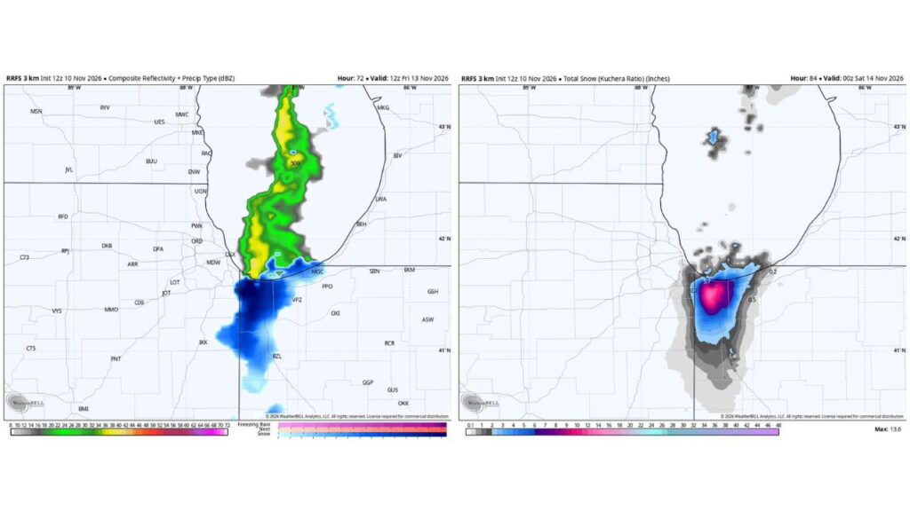
A short-range forecast for 6 a.m. CST Friday shows a long, narrow band of precipitation stretching north to south down Lake Michigan:
- Rain over much of the lake
- Snow pushing onshore into northwest Indiana, near Gary, Valparaiso and Merrillville
- Snow extending south toward Rensselaer
One Forecast Shows a Bullseye Near Gary and Valparaiso
The same forecast’s total snow through 6 p.m. CST Friday shows a compact bullseye over northwest Indiana:
| Area | Snow in This Forecast |
|---|---|
| Peak bullseye in northwest Indiana | Up to about 13.6 inches |
| Near the Indiana lakeshore | About 5.7 inches |
| Western edge near the Illinois border | About 2.7 inches |
| South toward Rensselaer | About 1.4 inches |
| Eastern edge toward Michigan City | About 0.5 inch |
| Southwest Michigan near the border | About 0.2 inch |
| Chicago area | Little to none |
This is just one model run, and totals are likely to change.
What Could Limit Snow Totals
Forecasters say a few factors could keep accumulations lower:
- Recent rainfall has left the ground wet
- Very warm ground temperatures after a mild fall can melt snow as it falls
What Could Make It a Bigger Event
On the other hand, if a stationary band sets up with snowfall rates of 1 inch per hour or more for several hours, snow could pile up quickly, even on warm ground.
Late-Season Lake-Effect Events Can Catch People Off Guard
Forecasters note that late October and early November lake-effect setups like this can sometimes get overlooked. Short-range models may continue trending colder and snowier, since long-range models often overestimate temperatures in these situations.
Part of a Colder Pattern Across the Region
The lake-effect threat follows a midweek cold front that is bringing below-normal temperatures to the Midwest, Ohio Valley and Great Lakes, along with mountain snow in East Tennessee and a possible coastal storm in the Northeast.
Travel Tips for Northwest Indiana
- Watch for sudden whiteouts in heavy snow bands
- Slow down on I-65, I-80 and I-94
- Keep an emergency kit in your car
- Check forecasts Thursday night before travel
Outlook: Keep an Eye on the Lake
Lake-effect snow is notoriously hard to pin down, so residents in Lake, Porter and nearby counties should watch forecast updates closely.
Stay with Bchssreport.com for the latest updates on this story.
About The Author
