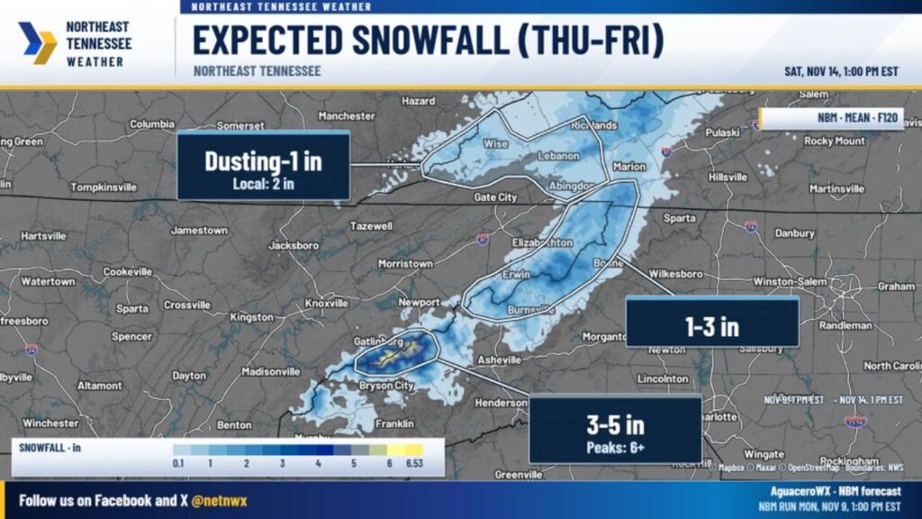
Great Smoky Mountains Could Get 3 to 6+ Inches of Snow Thursday Night Into Saturday as a Strong Cold Front Brings the Season’s First Mountain Snow to East Tennessee and Southwest Virginia
GATLINBURG, TENNESSEE — Widespread mountain snow is expected to begin Thursday night, November 12, 2026, and continue through Friday into early Saturday across the higher elevations of East Tennessee and Southwest Virginia.
The heaviest totals are forecast for the Great Smoky Mountains, where some peaks could top 6 inches.
Why the Mountains Will See Snow
The snow will come from a mix of northwest flow and orographic lift, when moist air is forced up the mountains and cools, after a strong cold front moves through.
Temperatures are expected to drop quickly behind the front, allowing rain to change to snow across most areas above 2,500 feet.
Snow Timeline
| Time | What to Expect |
|---|---|
| Thursday night, Nov. 12 | Snow begins in higher elevations |
| Friday, Nov. 13 | Steady mountain snow continues |
| Early Saturday, Nov. 14 | Snow tapers off |
Expected Snow Totals by Area
| Area | Forecast Snow |
|---|---|
| Great Smoky Mountains higher elevations | 3 to 5 inches |
| Highest Smoky peaks, including Mount Le Conte | 6+ inches |
| Northeast Tennessee mountains, Greene through Johnson County | 1 to 3 inches |
| Favored northwest-facing slopes in Northeast Tennessee | Locally higher than 3 inches |
| Tri-Cities and Southwest Virginia | Dusting to 1 inch |
| Higher elevations from Lee County into Wise County, Virginia | Up to about 2 inches |
| Knoxville and the valley | Rain only, no meaningful snow |
Smoky Mountains Get the Most Snow
The Smokies are expected to see the heaviest snow, with most higher elevations picking up 3 to 5 inches. The highest peaks, including Mount Le Conte, could see 6 inches or more. Forecast data shows a peak near 6.5 inches.
Northeast Tennessee Mountains: 1 to 3 Inches
Across the mountains of Northeast Tennessee, from Greene County through Johnson County, totals of 1 to 3 inches look likely. Spots near Erwin, Elizabethton and along the North Carolina border could see locally higher amounts on northwest-facing slopes.
Tri-Cities and Southwest Virginia: Mostly a Dusting
In the Tri-Cities and Southwest Virginia, rain may briefly mix with or change to snow, bringing a dusting to 1 inch in spots. Higher ground from Lee County into Wise County could see close to 2 inches.
Knoxville and the Valley Stay Rainy
Knoxville and the Tennessee Valley are expected to see only rain, with no meaningful snow accumulation.
Travel Impacts in the Mountains
While the valleys should not see major problems, higher elevations could have travel issues, especially where heavier snow falls:
- Road closures are possible in Great Smoky Mountains National Park
- Highway 441, Newfound Gap Road, could be affected
- Other high-elevation roads in Northeast Tennessee and Southwest Virginia may become slick or snow-covered
Early Forecast, but Models Are Consistent
Forecasters noted that it is still early and snow totals are not usually shared this far out, but computer models have been consistent enough to discuss possible amounts.
Part of a Colder Pattern Across the East
This first mountain snow follows a midweek cold front bringing below-normal temperatures to the Tennessee Valley and comes as forecasters watch a possible coastal storm with mountain snow in the Northeast.
Travel Tips for the Smokies
- Check road status before heading into the national park
- Carry winter gear and emergency supplies
- Avoid high-elevation roads during heavy snow
- Plan extra time for mountain travel
Stay with Bchssreport.com for the latest updates on this story.
About The Author
