Western Ski Areas From the Sierra to Colorado’s San Juans Set Up for Big Snow by Thanksgiving After a Dry Stretch, With Some Mountains Topping 30 to 65 Inches by Late December
WESTERN UNITED STATES — After a dry stretch across much of the West, snow is finally on the way for ski areas. Long-range forecasts show a slow start over the next week to 10 days, followed by a much snowier pattern heading into Thanksgiving and through late December.
Forecasters noted how quickly rain arrived after a “weak” monsoon this summer, and they expect a similar turnaround for mountain snow.
The Big Picture: Slow Start, Then Lots of Snow
| Period | What to Expect |
|---|---|
| Next 7 to 10 days | Mostly dry across much of the interior West |
| Week before Thanksgiving | Snow spreads into Utah, Colorado and the Rockies |
| Next 30 to 35 days after that | Heavy snow possible for many ski areas |
First Week: Snow Focused on the Sierra and Pacific Northwest
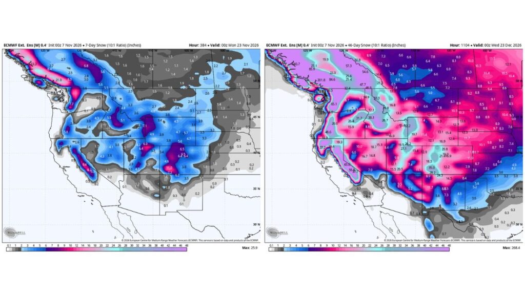
Forecast snow totals for the week ending Sunday evening, November 15, show the heaviest amounts closer to the Pacific:
| Area | 7-Day Snow Through Nov. 15 |
|---|---|
| Sierra Nevada | About 3.6 to 10.1 inches |
| Oregon Cascades | About 4.8 inches |
| Washington Cascades | About 5 to 6 inches |
| Central Idaho | About 3 to 3.6 inches |
| Wyoming Tetons | About 1.8 inches |
| Utah Wasatch | About 1.3 inches |
| Colorado mountains | Mostly under 1.3 inches |
Week Before Thanksgiving: Snow Expands Into the Rockies
By the week ending Sunday evening, November 22, snow spreads much farther inland:
| Area | 7-Day Snow Through Nov. 22 |
|---|---|
| San Juan Mountains, Colorado | About 11 inches |
| Central Colorado Rockies | About 6.4 to 6.5 inches |
| Northern Colorado mountains | About 5.6 to 5.7 inches |
| Utah Wasatch and Uintas | About 6.4 to 7.1 inches |
| Sierra Nevada | About 8.2 to 9.4 inches |
| Washington Cascades | About 7.7 inches |
| Oregon Cascades | About 5.8 inches |
| Idaho mountains | About 5.1 to 5.5 inches |
| Wyoming ranges | About 4.5 to 4.9 inches |
46-Day Totals Through December 22: Big Numbers for Ski Country
Looking further ahead, totals through late December show many ski areas picking up plenty of snow:
| Area | 46-Day Snow Through Dec. 22 |
|---|---|
| Washington Cascades | About 48 to 65 inches |
| Sierra Nevada | About 37 to 65 inches |
| Northern Rockies near the Canadian border | About 47 to 57 inches |
| Idaho mountains | About 26 to 39 inches |
| Colorado Rockies | About 20 to 35 inches |
| Utah mountains | About 19 to 27 inches |
| Oregon Cascades | About 48 inches |
| Northern Arizona and New Mexico mountains | About 8 to 12 inches |
Why a Dry Start Can Lead to a Snowy Finish
Forecasters say that if the West stays dry for the next 10 days, the following 30 to 35 days could make up for it with frequent storms. Long-range patterns often flip quickly, especially in an El Niño year.
Good News for Ski Resorts
Many resorts depend on early-season snow to open by Thanksgiving. Places like Wolf Creek in Colorado have already gotten a boost from recent storms, and the coming pattern could help more resorts open on time.
Long-Range Forecasts Come With Uncertainty
These totals are based on ensemble forecasts, which blend many model runs. They show general trends, not exact snow amounts, and can change as storms get closer.
Tips for Skiers and Mountain Travelers
- Check resort opening dates before booking trips
- Prepare vehicles for mountain driving
- Follow avalanche forecasts once snow builds up
- Keep an eye on weekly updates
Stay with Bchssreport.com for the latest updates on this story.
About The Author
