Northeast, Pacific Northwest and South Texas Line Up for Heavy Rain Through Monday as Cold Front Ends Long Dry Spell on the East Coast
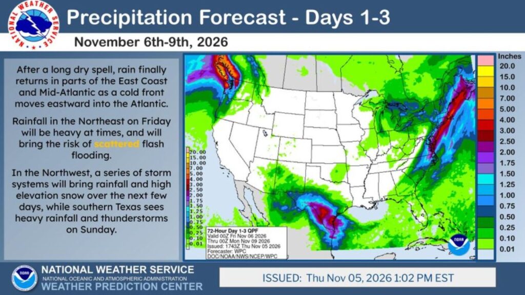
UNITED STATES — After a long dry spell, rain is finally returning to parts of the East Coast and Mid-Atlantic as a cold front pushes into the Atlantic. At the same time, the Pacific Northwest is bracing for a series of storms with heavy rain and high-elevation snow, while South Texas could see heavy rain and thunderstorms on Sunday.
Forecast Window: Friday Through Monday Morning
The National Weather Service’s Weather Prediction Center issued its three-day precipitation forecast on Thursday, November 5, 2026, at 1:02 p.m. EST, covering November 6 through November 9.
| Detail | Information |
|---|---|
| Forecast period | 7 p.m. EST Thursday, Nov. 5, through 7 p.m. EST Sunday, Nov. 8 |
| Issued | Thursday, Nov. 5, 2026, at 1:02 p.m. EST |
| Main rain zones | Northeast, Pacific Northwest, South Texas |
East Coast and Mid-Atlantic: Rain Returns After a Long Dry Spell
A cold front moving east into the Atlantic is bringing long-awaited rain to the East Coast. On Friday, rain in the Northeast is expected to be heavy at times, raising the risk of scattered flash flooding.
Projected Rainfall Totals by Region
| Region | Forecast Rainfall |
|---|---|
| Northeast and New England | About 1.5 to 4 inches |
| Upstate New York and Pennsylvania | About 1 to 2.5 inches |
| Mid-Atlantic coast | About 0.5 to 1.5 inches |
| Washington coast and Olympic Mountains | About 3 to 7+ inches |
| Cascades | About 2 to 5 inches, with snow up high |
| South Texas and the Rio Grande Valley | About 2 to 5 inches |
| Texas Gulf Coast | About 1 to 3 inches |
| Great Lakes | About 0.25 to 0.5 inch |
| Interior West and Plains | Little to no rain |
Northeast Faces Heaviest East Coast Totals
The heaviest East Coast rain is focused on the Northeast and New England, where totals could reach 3 to 4 inches in spots. Areas from New York through New England could see flooded roads and urban flooding during heavier bursts.
Pacific Northwest: A Parade of Storms
The Pacific Northwest is in line for a series of storm systems over the next few days. The Washington coast and Olympic Mountains could see several inches of rain, while high elevations in the Cascades pick up snow.
South Texas: Heavy Rain and Storms on Sunday
Gulf moisture is expected to surge into South Texas, bringing heavy rain and thunderstorms on Sunday, November 8. Totals of 2 to 5 inches are possible in parts of the Rio Grande Valley and coastal Texas, which could lead to localized flooding.
Much of the Country Stays Dry
While the coasts get soaked, much of the interior West, Rockies and Plains are expected to stay mostly dry during this period.
Why These Areas Are Getting Rain
- East Coast: A cold front pulling moisture from the Atlantic
- Pacific Northwest: Storm systems rolling in from the Pacific Ocean
- South Texas: Gulf of Mexico moisture fueling storms
Possible Impacts
- Flash flooding in the Northeast on Friday
- Mountain travel issues in the Cascades due to snow
- Flooded streets and low-water crossings in South Texas
- Welcome drought relief for parts of the dry East Coast
Safety Tips
- Never drive through flooded roads
- Check mountain pass conditions in the Northwest
- Keep weather alerts on for flash flood warnings
Stay with Bchssreport.com for the latest updates on this story.
About The Author
