Central North Carolina to Coastal New Jersey Under Flash Flood Watch-Out as Training Storms Tap Unusually Deep November Moisture Along a Cold Front
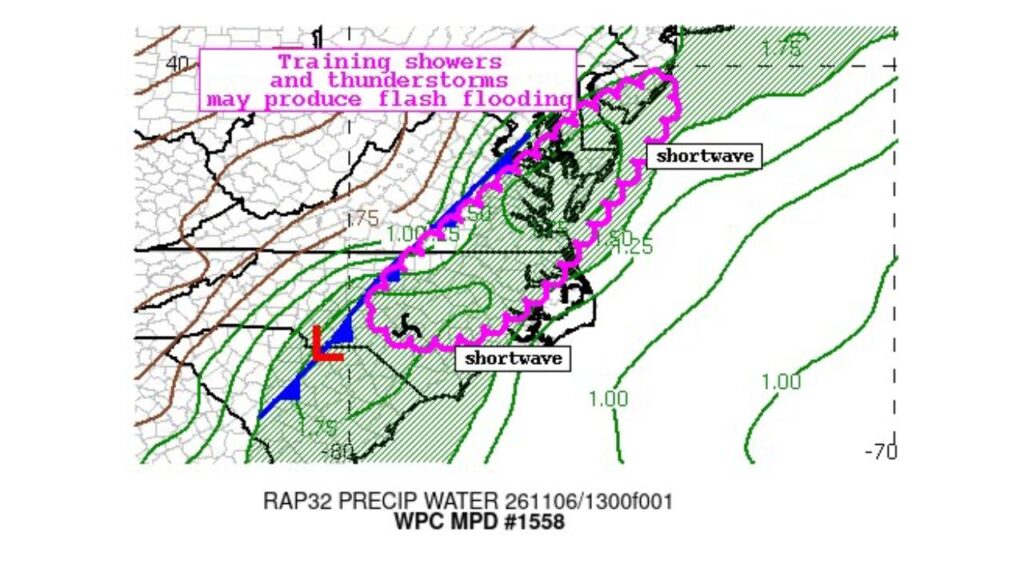
EASTERN VIRGINIA — Training showers and thunderstorms moving repeatedly over the same areas could bring flash flooding on Friday, November 6, 2026, across a long stretch of the East Coast, from central North Carolina to coastal New Jersey.
The Weather Prediction Center issued Mesoscale Precipitation Discussion #1558 for the region Friday morning.
Areas Under the Flash Flood Concern
| State | Areas Included |
|---|---|
| North Carolina | Central and eastern North Carolina |
| Virginia | Eastern Virginia, including the Hampton Roads area |
| Maryland | Eastern Maryland and the Eastern Shore |
| Delaware | Much of Delaware |
| New Jersey | Coastal New Jersey |
What “Training” Storms Means
Training happens when storms form and move one after another over the same area, like train cars on a track. Instead of passing through quickly, rain keeps falling on the same neighborhoods, causing totals to add up fast.
Unusually High Moisture for November
The discussion showed precipitable water, a measure of how much moisture is in the atmosphere, running around 1.5 to 1.75 inches inside the risk area. That is very high for November and means storms have plenty of moisture to produce heavy downpours.
| Area | Approximate Precipitable Water |
|---|---|
| Inside the risk zone | About 1.5 to 1.75 inches |
| Off the Atlantic coast | About 1.0 to 1.75 inches |
| Behind the cold front, inland | Much drier air |
Cold Front Stretching From the Carolinas to New Jersey
A cold front extended from western North Carolina northeast toward New Jersey, with an area of low pressure near the Carolinas. Ahead of the front, warm, humid air fed the storms, while drier air pushed in behind it.
Two Disturbances Helping Fuel the Storms
The discussion highlighted two shortwaves, small pockets of energy in the atmosphere:
- One over eastern North Carolina
- One off the Delmarva and New Jersey coast
These disturbances helped lift the moist air and keep storms developing and repeating along the front.
Same Front, Different Day
This setup is part of the same cold front that brought flash flood emergencies to Mississippi, Florida and Georgia earlier in the week. A separate flash flood concern was also issued Friday morning for New Jersey, New York City and southern New England.
Possible Flooding Impacts
Where storms train over the same spots, residents could see:
- Flooded streets and low-lying roads
- Overflowing ditches and small streams
- Ponding on highways like I-95 and I-64
- Urban flooding in cities with poor drainage
Tornado Risk Also in Play
Some of the same areas, including Raleigh and Norfolk, were also under a low tornado risk on Friday, with storms expected to weaken or move offshore by early evening.
Flash Flood Safety Tips
- Turn around, don’t drown if water covers the road
- Avoid low-water crossings and underpasses
- Keep alerts on for flash flood warnings
- Move to higher ground if water rises near your home
Outlook: Drier Air Arrives Behind the Front
Once the front pushes offshore, drier and cooler air is expected to move in, ending the flood threat and bringing a much chillier pattern to the Mid-Atlantic heading into next week.
Stay with Bchssreport.com for the latest updates on this story.
About The Author
