New Jersey, New York City and Southern New England Face Urban Flash Flood Threat Friday Morning as Storms Dump Up to an Inch of Rain in Just 15 Minutes
NEW JERSEY — Heavy downpours moving along the northern Mid-Atlantic coast and into southern New England on Friday morning, November 6, 2026, brought a threat of localized flash flooding, especially in urban areas.
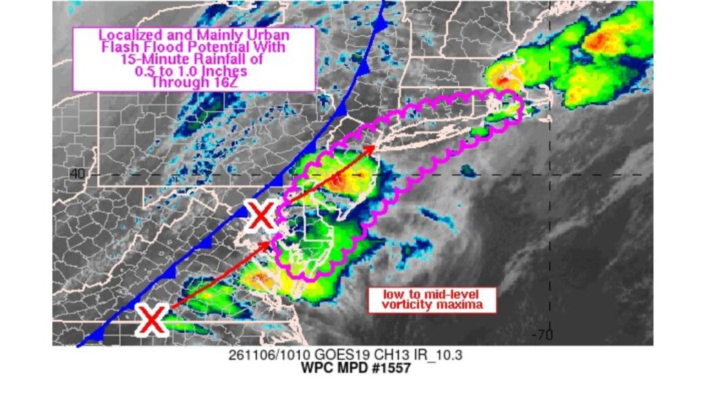
The Weather Prediction Center issued a corrected Mesoscale Precipitation Discussion #1557, warning that some storms could produce 0.5 to 1.0 inch of rain in just 15 minutes.
Flash Flood Concern Through 11 a.m. EST Friday
| Detail | Information |
|---|---|
| Discussion | WPC Mesoscale Precipitation Discussion #1557 (corrected) |
| Satellite time | About 5:10 a.m. EST Friday, November 6 |
| Valid through | 11 a.m. EST (16Z) Friday |
| Main threat | Localized, mainly urban flash flooding |
| Peak rainfall rates | 0.5 to 1.0 inch in 15 minutes |
Areas Under the Flash Flood Concern
The highlighted zone stretched along the coastal corridor from the northern Mid-Atlantic into southern New England, including parts of:
| State | Areas in or Near the Risk Zone |
|---|---|
| New Jersey | Central and northern New Jersey |
| New York | New York City and Long Island |
| Connecticut | Southern Connecticut coast |
| Rhode Island | Southern Rhode Island |
| Delaware and Maryland | Delmarva Peninsula |
| Pennsylvania | Southeast Pennsylvania near the coast corridor |
Hashtags in the alert also included Massachusetts and Virginia, which sat near the edges of the activity.
Why Cities Face the Biggest Risk
Flash flooding is more likely in urban areas because:
- Pavement and buildings keep water from soaking into the ground
- Storm drains can quickly become overwhelmed
- Underpasses and low-lying streets fill fast
- Basements and subway entrances can take on water
Rain Rates of Up to an Inch in 15 Minutes
The most intense storms were capable of dropping half an inch to a full inch of rain in only 15 minutes. Rain that heavy can turn streets into rivers within minutes, even if the storm does not last long.
Cold Front and Disturbances Driving the Storms
Satellite imagery showed a cold front stretching from the Mid-Atlantic northeast into New England. Along the front, low- to mid-level disturbances were tracking northeast, helping storms develop and intensify along the coast.
Heaviest Storms Over Central New Jersey
At the time of the satellite image, some of the strongest cells were located over central New Jersey, with more storms developing to the southwest across the Delmarva Peninsula and spreading northeast toward New York and southern New England.
Part of the Same Front That Brought Southern Floods
This front is the same system that brought damaging storms, a tornado risk and flash flood emergencies across the Southeast earlier in the week before reaching the East Coast.
Morning Commute Impacts
The timing could affect Friday morning commutes, with possible:
- Flooded roads and highway ramps
- Delays on trains and subways
- Slow traffic in heavy downpours
- Reduced visibility for drivers
Urban Flood Safety Tips
- Never drive through flooded streets or underpasses
- Avoid walking near storm drains during heavy rain
- Check transit updates before heading out
- Move valuables up if your basement floods easily
- Keep weather alerts on for flash flood warnings
Outlook: Threat Eases by Late Morning
The flash flood concern was expected to ease after 11 a.m. EST as storms moved offshore and the front pushed east.
Stay with Bchssreport.com for the latest updates on this story.
About The Author
