Mississippi, Florida and Georgia Hit by Three Flash Flood Emergencies in One Week as Up to 26 Inches of Rain Falls, and El Niño Could Bring More
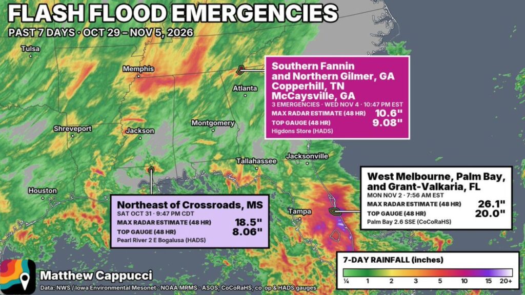
SOUTHEAST — The past week brought a rare trio of high-end flash flood events across the southern United States, with Flash Flood Emergencies issued in Mississippi, Florida and Georgia between October 31 and November 4, 2026.
Radar estimated as much as 26.1 inches of rain in one Florida community, while rain gauges in all three states recorded extreme totals from slow-moving thunderstorms.
Three Flash Flood Emergencies in One Week
| Location | Date and Time | Max Radar Estimate (48 Hours) | Top Gauge (48 Hours) |
|---|---|---|---|
| Northeast of Crossroads, Mississippi | Sat, Oct. 31, 9:47 p.m. CDT | 18.5 inches | 8.06 inches, Pearl River 2 E Bogalusa |
| West Melbourne, Palm Bay and Grant-Valkaria, Florida | Mon, Nov. 2, 7:56 a.m. EST | 26.1 inches | 20.0 inches, Palm Bay 2.6 SSE |
| Southern Fannin and Northern Gilmer, Georgia; Copperhill, Tennessee; McCaysville, Georgia | Wed, Nov. 4, 10:47 p.m. EST | 10.6 inches | 9.08 inches, Higdons Store |
Event One: Mississippi and Louisiana, Halloween Night
The first emergency came on Halloween night near Crossroads, Mississippi, in Pearl River County, close to the Louisiana border. A storm stalled over the same small area for hours.
| Location | 24-Hour Rainfall Ending 7 a.m. CST Sunday, November 1 |
|---|---|
| Pearl River County bullseye | 18.5 inches (radar estimate) |
| Gauge near Bogalusa | 8.06 inches |
| Nearby gauges | 3.58 to 3.78 inches |
| Near Oakdale, Louisiana | 16.0 inches (radar estimate), under flash flood warnings |
Event Two: Florida’s Space Coast, Monday Morning
The most extreme rainfall hit Brevard County, Florida, where a Flash Flood Emergency covered West Melbourne, Palm Bay and Grant-Valkaria.
| Location | 24-Hour Rainfall Ending 11 p.m. EST Monday, November 2 |
|---|---|
| Palm Bay area bullseye | 23.8 inches (radar estimate) |
| Gauges near Melbourne and Palm Bay | 11.1 to 12.0 inches |
| Interior Florida gauges | 8.81 to 9.24 inches |
Over 48 hours, a rain gauge near Palm Bay measured 20.0 inches, while radar estimated up to 26.1 inches.
Event Three: North Georgia Mountains, Wednesday Night
The third event struck the north Georgia mountains near the Tennessee border, where three Flash Flood Emergencies were issued for southern Fannin County, northern Gilmer County, McCaysville, Georgia, and Copperhill, Tennessee.
Radar estimated 8.42 inches in 24 hours ending 10 a.m. EST Thursday, November 5, with 48-hour totals reaching 10.6 inches. A gauge at Higdons Store recorded 9.08 inches. Officials reported mudslides and water rescues.
Why These Storms Were So Extreme
All three events were mesoscale floods, meaning they hit small areas with intense, repeated thunderstorms. Storms trained over the same spots for hours, causing rainfall to pile up quickly while nearby areas received far less.
El Niño’s Role in the Southern Storm Track
As Dr. Postel pointed out, El Niño cool seasons often feature a stronger subtropical jet stream across the southern U.S. That more active jet can feed moisture and energy into storms, raising the risk of high-end flood events like the ones seen this week.
More Wet Weather Possible This Winter
With a strong El Niño in place, forecasters expect a wetter-than-normal winter across much of the South, especially Florida and the Gulf Coast, where seasonal outlooks show rainfall running well above normal.
Flash Flood Safety Reminders
- Never drive through flooded roads
- Move to higher ground immediately when warned
- Stay away from creeks, washes and low areas
- Keep emergency alerts on, especially overnight
Stay with Bchssreport.com for the latest updates on this story.
About The Author
