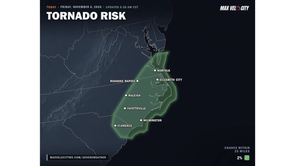
Eastern North Carolina, Southeast Virginia and Northeast South Carolina Face Brief Tornado Risk Friday From Florence and Raleigh to Norfolk Before Storms Move Offshore
RALEIGH, NORTH CAROLINA — A brief tornado or two cannot be ruled out on Friday, November 6, 2026, across parts of eastern North Carolina, southeast Virginia and northeast South Carolina, from Florence and Raleigh to Norfolk.
Storms are expected to fire up late morning to midday before weakening or moving offshore by early evening.
Tornado Risk Area for Friday
The outlook, updated at 6:58 a.m. CST, shows a 2% chance of a tornado within 25 miles of any point inside the highlighted zone. While that number sounds small, it is enough to keep forecasters on alert.
| State | Cities in the Risk Area |
|---|---|
| North Carolina | Raleigh, Fayetteville, Wilmington, Roanoke Rapids, Elizabeth City |
| Virginia | Norfolk and the Hampton Roads area |
| South Carolina | Florence |
The risk area also extends to the Outer Banks and the southern tip of the Delmarva Peninsula.
Storm Timeline for Friday
| Time | What to Expect |
|---|---|
| Late morning | Storms begin developing |
| Midday | Peak window for a brief tornado |
| Afternoon | Storms move northeast toward the coast |
| Early evening | Storms weaken or push offshore |
What a 2% Tornado Risk Means
A 2% risk is the lowest tornado probability typically shown on forecast maps. It means tornadoes are possible but not widespread. Any tornado that forms is likely to be brief and weak, but even short-lived tornadoes can cause damage.
Part of the Same Storm System Crossing the East
These storms are linked to the cold front that has brought rain, storms and flooding across the Southeast this week, including flash flooding in north Georgia and storms in Central Alabama. The front is now moving toward the East Coast.
Other Possible Hazards With Friday’s Storms
Along with a brief tornado, storms could bring:
- Gusty winds capable of downing tree limbs
- Heavy downpours and ponding on roads
- Frequent lightning
- Reduced visibility on highways like I-40 and I-95
Coastal Communities Also in the Risk Zone
The tornado risk extends to coastal areas, including Wilmington, the Outer Banks and Norfolk. Storms may strengthen briefly as they approach the coast before moving out over the Atlantic Ocean.
Tornado Safety Reminders
- Know your safe place, such as an interior room on the lowest floor
- Keep weather alerts on during the late morning and afternoon
- Avoid driving into heavy rain or storms when possible
- If outdoors, seek sturdy shelter immediately when a warning is issued
- Mobile home residents should plan where they will go if a warning is issued
Outlook: Cooler, Drier Air Follows the Storms
Once the storms move offshore by early evening, cooler and drier air is expected to move into the Carolinas and Virginia heading into the weekend.
Stay with Bchssreport.com for the latest updates on this story.
About The Author
