
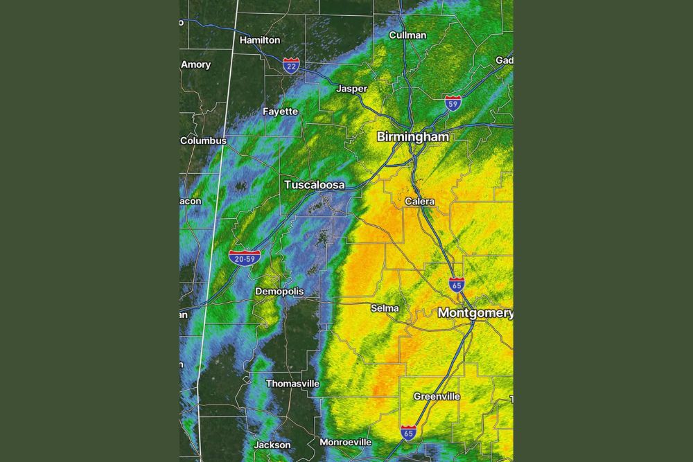
Large Batch of Rain From Isaias Moves Into West Alabama Late Friday Night as Gusty Winds Raise the Risk of Scattered Power Outages
West Alabama – A large batch of rain tied to Isaias pushed into west Alabama from the southeast late Friday night. As of 10:45 p.m., light rain was already falling over much of the region, and it’s expected to increase in coverage and intensity over the next few hours. Gusty winds are also picking up across the area, which could lead to scattered power outages later tonight.
Rain Shield Covers Much of Central and South Alabama
Radar from the Birmingham (KBMX) station showed a broad shield of rain stretching across a large part of the state. The heaviest rain at the time was in central and south-central Alabama, with moderate to heavy rain around Birmingham, Calera, Selma, Montgomery, and Greenville.
Rain also extended north toward Cullman and Gadsden, and south toward Monroeville and Andalusia. Some of the strongest returns on radar were between Selma and Greenville and in the Interstate 65 corridor south of Montgomery.
Light Rain Spreading Across West Alabama
Farther west, lighter rain was falling across Tuscaloosa, Demopolis, Fayette, Jasper, and Hamilton, along with Thomasville and Jackson in southwest Alabama. Rain was also reaching across the state line into northeast Mississippi, near Columbus and Amory.
These areas sat on the western edge of the main rain shield, but that’s expected to change over the next few hours. As the system keeps moving, heavier rain will spread farther west, bringing steadier, more intense rain to communities along the Interstate 20/59 corridor, including Tuscaloosa and Demopolis.
Gusty Winds Developing
Along with the rain, gusty winds are developing across the area. As Isaias moves inland after landfall along the Gulf Coast, its circulation is still strong enough to produce strong gusts well away from the coast.
Wind and rain-soaked ground together can bring down tree limbs and even whole trees, especially ones with shallow roots or that are already weakened. That raises the risk of scattered power outages later tonight and into early Saturday.
How to Prepare Overnight
Since the worst conditions are arriving overnight, residents should get ready before going to bed. Make sure phones are charged, keep flashlights and extra batteries within reach, and turn on emergency alerts to receive any warnings that are issued.
Anyone who relies on electricity for medical equipment should have a backup plan in case of an outage. Secure outdoor items like trash cans, patio furniture, and decorations that could be blown around by strong winds.
Stay Off the Roads If Possible
Driving overnight could be dangerous because of heavy rain, reduced visibility, standing water, and possible downed trees or power lines on roads. If you must drive, slow down, use headlights, and never drive through flooded roads.
Stay at least 35 feet away from any downed power line and report it to your utility company. Always assume a downed line is live and dangerous.
Watch for Isolated Tornadoes
Landfalling tropical systems can sometimes produce brief tornadoes in their rain bands, often with little warning. Residents should keep a way to receive warnings overnight, such as a NOAA Weather Radio or alerts on their phones, and know where their safe place is at home.
What’s Next
Isaias is expected to keep weakening as it moves north through Alabama on Saturday, eventually becoming a tropical depression by Saturday evening as it heads toward the Tennessee border. Rain and gusty winds will spread into north Alabama on Saturday, with wind gusts of 30 to 45 mph and 1 to 3 inches of rain possible. The storm should pull away from the region early Sunday.
For more Alabama weather updates and Isaias coverage, stay with bchssreport.com.