
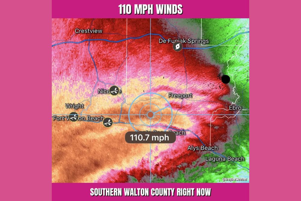
Hurricane Isaias Eyewall Brings 110 MPH Winds to Southern Walton County Near Santa Rosa Beach and Freeport as Extreme Wind Warning Takes Effect
WALTON COUNTY, Fla. — The eyewall of Hurricane Isaias moved ashore over southern Walton County in the Florida Panhandle Friday evening, bringing extremely dangerous winds. Radar velocity data from the Eglin Air Force Base radar showed winds of about 110 mph near Santa Rosa Beach at 7:40 p.m. EDT. Isaias was making landfall as a Category 3 hurricane at the time. An Extreme Wind Warning was in effect for areas in the path of the eyewall.
Radar Shows 110 MPH Winds Over Santa Rosa Beach
Radar velocity imagery showed winds near 110.7 mph centered over southern Walton County near Santa Rosa Beach. The strongest winds were focused within the hurricane’s eyewall as it crossed the coastline.
High winds stretched across a wide area, including Fort Walton Beach, Niceville, Freeport, and Alys Beach. Areas near Laguna Beach and Ebro were also feeling strong winds on the storm’s eastern side.
Isaias Makes Landfall as a Category 3 Hurricane
Isaias was making landfall as a Category 3 hurricane as the eyewall moved over the coast. The eyewall is the most dangerous part of a hurricane, containing the strongest winds.
Residents in the path of the eyewall face life-threatening conditions. Destructive winds can damage roofs, break windows, and topple trees and power lines.
Extreme Wind Warning in Effect
An Extreme Wind Warning was issued for areas under the eyewall. This warning is reserved for the most dangerous winds, typically 115 mph or greater, that are occurring or imminent.
Winds of this strength can destroy homes and turn loose debris into dangerous projectiles. Anyone in the warning area should take immediate shelter.
Shelter in a Safe Room Away From Windows
Residents in the eyewall’s path should stay in a safe room or interior space on the lowest floor of their home. Staying away from windows and exterior walls is critical.
Do not go outside during the calm of the eye if it passes overhead. Winds can return suddenly and violently from the opposite direction.
Strong Winds Spreading Inland
Strong winds are also spreading inland toward Crestview, De Funiak Springs, and northern Walton County. Damaging gusts are likely as the storm continues moving north.
Widespread power outages and tree damage are expected across the Panhandle and into southern Alabama. Travel will remain extremely dangerous until conditions improve.
Stay Sheltered Until the Storm Passes
Residents should remain indoors until official sources confirm it is safe to go outside. Downed power lines, flooding, and debris will create hazards after the storm passes.
Following updates from local emergency officials and the National Weather Service is essential. Recovery efforts will begin once Isaias moves farther inland.