
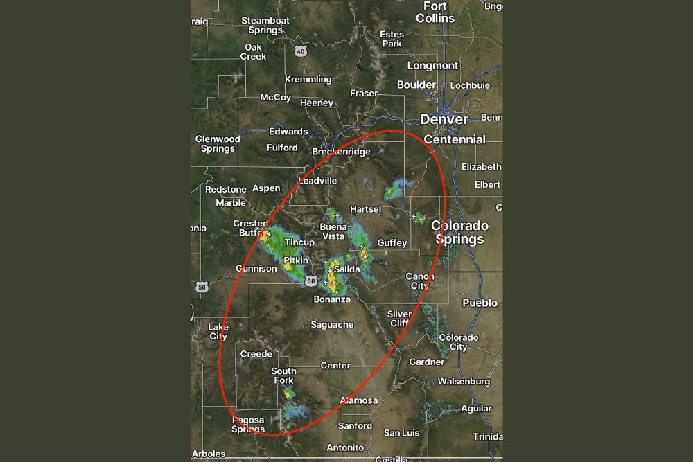
Isolated Slow-Moving Storms Develop Over Colorado’s Central and Southern Mountains With a Similar Setup Monday and More Coverage Possible Tuesday
Colorado – A few isolated thunderstorms have been developing over Colorado’s central and southern mountains, bringing pockets of rain, lightning, and gusty winds to parts of the high country. The storms are very slow moving, which means some areas could see rain linger over the same spots for a while. A similar story is expected on Monday, with storm coverage possibly increasing a bit on Tuesday.
Where the Storms Are Developing
Radar shows scattered storms popping up across the central mountains, including areas near Crested Butte, Tincup, and Pitkin in Gunnison County. Additional storms were developing farther east near Buena Vista and Salida in the Arkansas River Valley, along with areas around Bonanza and along U.S. Highway 50 near Monarch Pass.
More isolated cells were showing up near Hartsel in South Park and close to the Guffey area in Park and Teller counties. Farther south, storms were also developing over the San Juan Mountains, near South Fork and the high terrain northeast of Pagosa Springs.
Frequent lightning was detected with several of the storms, especially near Salida, Buena Vista, and Crested Butte.
Very Slow Moving Storms
One of the biggest concerns with these storms is how slowly they are moving. When storms barely drift, they can drop rain over the same area for an extended period of time. Even though the storms are isolated, slow movement can lead to locally heavy rainfall and pockets of ponding on roads or quick rises on small creeks and streams in mountain areas.
Slow-moving storms also mean that lightning can stay over the same areas for longer periods, increasing the danger for anyone outdoors.
Burn Scar Flooding Risk
Anyone near recent burn scars in the mountains should be especially cautious. Burned areas can produce flash flooding and debris flows from even modest amounts of rain because the soil does not absorb water well. With storms moving slowly, any heavy rain that sets up over a burn scar could quickly cause problems downstream.
Residents and travelers near burn scars should stay alert for flash flood warnings and be ready to move to higher ground if needed.
Lightning Danger for Hikers and Hunters
The mountains are busy this time of year with hikers, campers, and hunters heading out to enjoy fall colors and early hunting seasons. Thunderstorms in the high country can bring dangerous lightning, especially above the treeline, where there is little shelter.
Anyone heading into the backcountry should plan to be off ridges and peaks by early afternoon, when storms are most likely to develop. If thunder is heard, it is time to head to a safer location. Lightning can strike miles away from the main storm.
Similar Setup Expected Monday
The weather pattern is expected to stay similar on Monday, with a few isolated storms developing over the central and southern mountains during the afternoon. Like the previous storms, they are expected to be slow moving, so localized heavy rain and lightning will remain the main concerns.
Lower elevations, including the Denver metro area, Colorado Springs, and Pueblo, are expected to stay mostly dry, though a stray shower or storm could drift off the higher terrain.
More Storm Coverage Possible Tuesday
By Tuesday, storm coverage may increase a bit across the mountains. While the storms are still expected to be scattered rather than widespread, more areas could see rain and thunder compared to the previous days. Anyone with outdoor plans in the mountains on Tuesday should keep a close eye on the forecast.
Fall Colors and Mountain Travel
Many people are heading into the mountains this time of year to see fall colors, especially near places like Crested Butte, Buena Vista, Salida, and Monarch Pass. Travelers should be prepared for changing conditions, including heavy rain, lightning, gusty winds, and reduced visibility on mountain roads and passes.
Driving through heavy rain on winding mountain roads can be dangerous, so drivers should slow down and use caution, especially on highways like U.S. 50, U.S. 285, and U.S. 24.
Snow at the Highest Peaks?
With cooler temperatures at high elevations, some of the heavier storms could briefly bring graupel or a few snowflakes to the highest peaks. While significant snow is not expected, early-season wintry conditions at very high elevations are not unusual in October.
Stay Weather Aware in the High Country
Colorado’s mountain weather can change quickly, especially in the afternoon. Residents and visitors should keep checking the forecast, carry rain gear, and be ready to adjust plans if storms develop nearby.
For more Colorado weather updates and mountain forecasts, stay with bchssreport.com.