
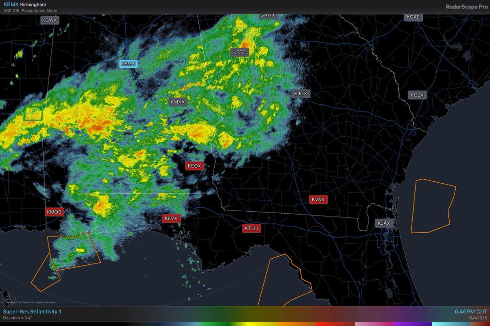
Rare Radar Data Outage Leaves Five Gulf Coast Radars Hidden From the Public as Storms Move Through Alabama, Florida, and Georgia
Mobile, Alabama – A rather bizarre radar communication outage is affecting several key weather radars along the Gulf Coast, leaving the public, the media, and popular weather apps without access to important data during an active stretch of weather. The radars themselves are working normally and can still be viewed by local National Weather Service offices, but the data is not reaching the rest of the world. As of Sunday night, there was no estimated time for when the data would be restored.
Which Radars Are Affected?
The outage involves five Doppler radars that cover a large part of southern Alabama, the Florida Panhandle, and southern Georgia. These include KMOB in Mobile, Alabama, KEOX near Fort Novosel, formerly Fort Rucker, in southeast Alabama, KEVX at Eglin Air Force Base in the Florida Panhandle, KTLH in Tallahassee, Florida, and KVAX at Moody Air Force Base in south Georgia.
Together, these radars monitor weather across a wide stretch of the Gulf Coast, including Mobile, Pensacola, Destin, Panama City, Dothan, Tallahassee, and Valdosta, along with the coastal waters of the Gulf.
Radars Working, But Data Not Reaching the Public
The unusual part of this situation is that the radars are not broken. They are scanning the sky and collecting data as normal, and local National Weather Service offices can still see the information. That means forecasters in places like Mobile and Tallahassee can still issue warnings based on what the radars detect.
The problem is that the data is not being sent out to the wider network that delivers radar images to the public. As a result, high-resolution, single-site radar data from these locations is not available on many weather apps, websites, and TV stations.
What Caused the Outage?
The issue began with a fiber optic cable cut, which disrupted the connection used to send radar data out to the broader network. After that, a network card had to be replaced as crews worked to restore service. However, even after those repairs, the problem continued into Sunday night, and there is still no timeline for when full access to the data will return.
Tornado Warning Without Public Radar Data
The outage became especially concerning on Sunday when the National Weather Service in Mobile issued a tornado warning for Fort Morgan in coastal Baldwin County, Alabama. Forecasters at the Mobile office were able to see the radar data and issue the warning, but TV meteorologists and weather apps had no local radar data to show the public.
That made it much harder for broadcasters to explain the threat, show viewers where the storm was located, or track its movement in detail. Situations like this highlight just how important public access to radar data is during severe weather.
Active Weather Across the Region
The outage comes at a time when the Southeast is dealing with active weather. A Level 2 of 4 flood risk was in place across much of the region on Sunday, with 2 to 4 inches of rain expected in many areas. Radar from surrounding sites that remain available, including Birmingham, Atlanta, Jacksonville, and Columbus, showed widespread rain and storms stretching across Alabama and Georgia, with additional storms near the Mobile Bay area and coastal Alabama.
With storms capable of producing heavy rain, flash flooding, and isolated tornadoes, having full radar coverage is critical for keeping people informed and safe.
How Residents Can Stay Safe During the Outage
Even though public radar data from these sites is limited, warnings are still being issued by the National Weather Service. That is the most important thing for residents to know.
People living in southern Alabama, the Florida Panhandle, and south Georgia should make sure they have multiple ways to receive warnings. That includes Wireless Emergency Alerts on cell phones, a NOAA Weather Radio, local TV and radio broadcasts, and weather apps that send push notifications for warnings. Even if radar images are not available, warning alerts will still go out.
Nearby Radars Can Help Fill Gaps
Some weather apps and websites can display data from nearby radar sites that are still working, such as Birmingham, Maxwell Air Force Base near Montgomery, Atlanta, Jacksonville, and Lake Charles. While these radars can show some of the weather across the affected region, they are farther away, which means they may miss lower-level features in storms, including rotation that could lead to tornadoes.
That is why the local radars are so important, and why restoring access to their data is a priority.
Why This Matters
Radar data plays a huge role in keeping people safe during severe weather. It helps meteorologists track storms, rotation, heavy rain, and flooding, and it allows residents to see what is heading their way. When that data is missing, it becomes harder for broadcasters and the public to understand fast-changing weather situations, even if warnings are still being issued.
No Timeline for Restoration
At this time, there is no estimated time for when the radar data will be fully restored to the public. Residents in the affected areas should stay alert, keep their warning devices on, and follow guidance from local officials and the National Weather Service until the issue is resolved.
For more Gulf Coast weather updates and severe weather news, stay with bchssreport.com.