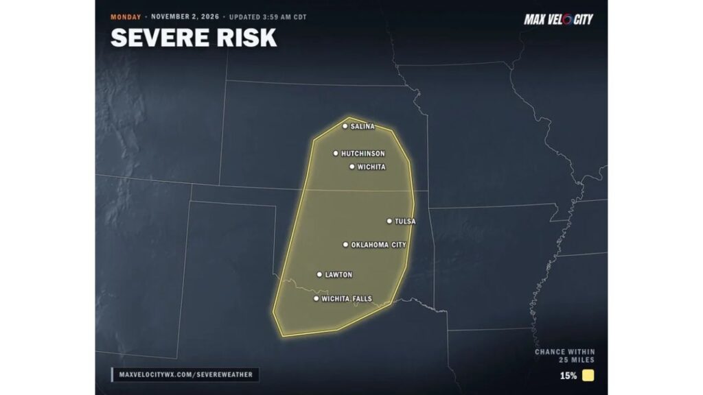
Kansas, Oklahoma and North Texas Face Severe Storms Monday Afternoon, November 2, With Damaging Winds, Large Hail and a Couple of Tornadoes Possible From Wichita to Oklahoma City and Tulsa
OKLAHOMA CITY, OKLAHOMA — Severe thunderstorms are becoming increasingly likely on Monday afternoon, November 2, 2026, across central Kansas, Oklahoma and north Texas, including the Wichita, Oklahoma City and Tulsa areas.
Damaging winds are expected to be the main threat, but a couple of tornadoes and some large hail are also possible.
Severe Risk Area: Salina to Wichita Falls
The severe weather outlook, updated at 3:59 a.m. CDT Monday, highlights a zone with a 15% chance of severe weather within 25 miles of any given point. Cities inside the risk area include:
| State | Cities in the Risk Zone |
|---|---|
| Kansas | Salina, Hutchinson, Wichita |
| Oklahoma | Tulsa, Oklahoma City, Lawton |
| Texas | Wichita Falls |
What Is Driving Monday’s Storms
A strong storm system moving into the Plains will pull warm, humid air north ahead of a cold front. As the front pushes through, storms are expected to fire along it during the afternoon.
Strong Winds Aloft Could Help Early Storms Rotate
Powerful winds high in the atmosphere will help some of the early storms rotate. That rotation is what raises the chance for tornadoes and large hail in the first part of the event.
Storms Merge Into Lines Monday Evening
As the evening goes on, storms are expected to merge into lines. When that happens, the threat shifts mainly to damaging straight-line winds that can spread across a wide area.
Main Hazards Monday Afternoon and Evening
| Hazard | Risk Level |
|---|---|
| Damaging winds | Main threat |
| Large hail | Possible, mainly with early storms |
| Tornadoes | A couple possible, mainly with early rotating storms |
Timing: Afternoon Development, Evening Lines
- Monday afternoon: Storms form along the cold front, with some rotating early
- Monday evening: Storms merge into lines with mainly a damaging wind threat
- Monday night: Storms push east and south as the front advances
Tuesday: Storms Shift Into East Texas, Arkansas, Louisiana and Mississippi
The storm system keeps moving on Tuesday, November 3, shifting into:
- East Texas
- Arkansas
- Louisiana
- Mississippi
Damaging winds will be possible in those areas as well.
Part of a Larger Early-November Storm System
This severe threat is part of the strong storm system forecasters have been watching for days, which is also expected to bring heavy rain, gusty winds and a wintry side farther north and west.
How to Prepare Before Monday Afternoon
- Know your safe place, such as a basement or interior room on the lowest floor
- Charge phones and make sure weather alerts are on
- Secure outdoor items ahead of damaging winds
- Plan your evening commute around the storms
- Have a flashlight ready in case of power outages
Late-Season Severe Weather Is a Real Threat
While spring is peak severe weather season, November storms can still bring damaging winds and tornadoes to the southern Plains when warm, humid air meets a strong cold front.
Outlook: Forecast Updates Through Monday Morning
Forecasters will keep updating the risk as Monday approaches. Residents across Kansas, Oklahoma and north Texas should check for watches and warnings throughout the day.
Stay with Bchssreport.com for the latest updates on this story.
About The Author
