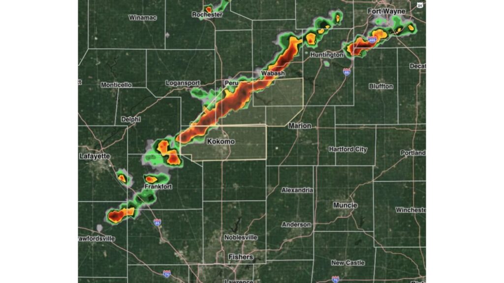
Cass, Grant, Miami, Wabash and Howard Counties in Indiana Hit With Strong Storm Statement as Line of Storms Brings 40 to 50 MPH Wind Gusts Through Kokomo and Wabash
KOKOMO, INDIANA — A strong storm statement was issued for portions of Cass, Grant, Miami, Wabash and Howard counties in north-central Indiana as a line of storms pushed through the area with gusty winds of 40 to 50 mph.
The statement remained in effect until 5:45 p.m. ET.
Strong Storm Statement Details
| Detail | Information |
|---|---|
| Counties | Cass, Grant, Miami, Wabash, Howard |
| Main Threat | Strong gusty winds |
| Wind Gusts | 40 to 50 mph |
| In Effect Until | 5:45 p.m. ET |
Line of Storms Stretches From Crawfordsville to Fort Wayne
Radar showed a long, narrow line of storms stretching from southwest to northeast across north-central Indiana. The line ran from near:
- Crawfordsville and Frankfort in the southwest
- Through Kokomo, Peru and Wabash in the middle
- Up toward Huntington and Fort Wayne in the northeast
Strongest Cells Near Kokomo, Peru and Wabash
The most intense part of the line showed up on radar between Kokomo and Wabash, passing near Peru. Bright red and orange colors on radar indicated heavy rain and stronger winds in that section.
Other strong pockets appeared near Huntington and Fort Wayne, along with scattered storms near Frankfort and Crawfordsville.
Communities Inside or Near the Statement Area
Cities and towns in or close to the affected counties include:
- Kokomo in Howard County
- Logansport in Cass County
- Peru in Miami County
- Wabash in Wabash County
- Marion in Grant County
Areas Southeast of the Line Stayed Mostly Dry
At the time of the radar image, cities to the southeast, such as Muncie, Anderson, Noblesville, Fishers, Hartford City and New Castle, remained mostly clear of storms.
What 40 to 50 MPH Winds Can Do
While these winds fall below severe levels, gusts of 40 to 50 mph can still cause problems, including:
- Downed tree limbs and small branches
- Scattered power outages
- Loose outdoor items, such as trash cans, patio furniture and decorations, being blown around
- Difficult driving, especially for high-profile vehicles
Heavy Rain and Lightning Also Possible
Along with gusty winds, storms in the line could bring brief heavy downpours, reducing visibility on roads, and lightning, which is dangerous for anyone outdoors.
What Residents Should Do During the Storms
- Move indoors until the line passes
- Secure loose outdoor objects
- Avoid parking under trees
- Slow down on roads during heavy rain and gusty winds
- Stay alert for any upgrades to severe thunderstorm warnings
Strong Storm Statement vs. Severe Thunderstorm Warning
A strong storm statement is used when storms are expected to bring gusty winds or small hail that fall below severe criteria. A severe thunderstorm warning is issued when winds of 58 mph or greater or hail 1 inch or larger are expected. Conditions can change quickly, so residents should keep watching alerts.
Outlook: Storms Expected to Exit the Area After 5:45 p.m.
The line of storms was moving east and northeast and was expected to move out of the affected counties by 5:45 p.m. ET. Residents farther east should stay alert as the storms continue on their path.
Stay with Bchssreport.com for the latest updates on this story.
About The Author
