
North Carolina Transitions From Near-Record Heat as a Cold Front Brings Clouds, Scattered Showers, and Cooler Air Into the Weekend
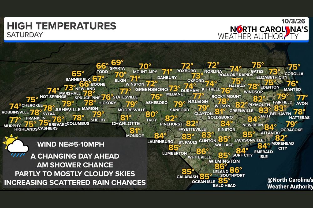
North Carolina – Saturday is a changing day across North Carolina. After near-record highs on Friday, the state is now in a transition as a cold front moves in. Skies will be partly to mostly cloudy with increasing clouds, while scattered showers and even a few thunderstorms are possible. Temperatures will peak around midday in the 60s, 70s, and 80s, before falling through the evening as cooler air settles in.
Clouds Increase as the Cold Front Arrives
The cold front that forecasters have been tracking all week is now moving into North Carolina. As it arrives, clouds will increase across the state throughout the day, replacing the sunshine that dominated the end of the workweek. Winds will come from the northeast at 5 to 10 mph, helping to usher in the cooler air behind the front.
Highs Peak Midday Then Drop
Unlike a typical day where temperatures climb through the afternoon, many areas will reach their highs around midday on Saturday. After that, temperatures are expected to drop through the evening, with the 60s and 70s becoming more common as the front pushes through.
Warmest in Southeastern North Carolina
The southeastern part of the state will hold onto the warmth the longest. Whiteville, Leland, and Southport are expected to reach around 86 degrees, making them the warmest spots in the state. Lumberton, Wilmington, Calabash, Ocean Isle, and Bald Head Island should top out near 85, along with Jacksonville and Wallace.
Laurinburg, Kinston, New Bern, Surf City, and Emerald Isle are expected to reach about 84 degrees, while St. Pauls and Clinton come in near 83. Fayetteville and Pinehurst should reach about 82 degrees.
Piedmont and Central North Carolina
Across the Piedmont, temperatures will be noticeably cooler than Friday. Charlotte and Monroe are expected to reach around 81 degrees, while Troy comes in near 80. Mooresville, Sanford, and Clayton should top out around 79, and Raleigh is expected to reach about 77 degrees.
Farther north, the cooler air will already be settling in. Durham is forecast to reach about 74, Oxford and Mebane near 73, and Greensboro and Roxboro around 72 degrees. Winston-Salem and Danbury should top out near 71, while Mount Airy and Elkin reach only around 70.
Mountains Stay Cool
The North Carolina mountains will be among the coolest areas. Banner Elk is expected to reach only about 65 degrees, while Todd and Boone stay near 66. Sparta should top out around 69 degrees.
Lower elevations in the mountains will be milder. Asheville is expected to reach the upper 70s, while Hot Springs and Robbinsville come in near 74. Cherokee, Highlands, and Cashiers should reach about 75, and Murphy near 77 degrees. In the foothills, Shelby will reach about 79, while Marion and Columbus top out near 78.
Coastal and Northeastern North Carolina
In northeastern North Carolina, temperatures will stay in the 70s. Elizabeth City is expected to reach about 73 degrees, while Roanoke Rapids comes in near 74. Gates, Halifax, and Corolla should reach around 75, with Manteo near 76 and Avon near 77. Hatteras is forecast to reach about 78, and Ocracoke around 79 degrees.
Along the central coast, Morehead City should reach about 82, while Atlantic comes in near 84. Greenville, Plymouth, and Bath are expected to reach the low 80s.
Scattered Showers Through the Day
Rain chances will be a big part of Saturday’s forecast. A few scattered showers are possible during the morning, and coverage will increase during the afternoon. Some areas could also see a thunderstorm or two as the front moves through.
This will not be a washout, and many areas will see dry periods between showers. However, anyone with outdoor plans should keep a close eye on the radar throughout the day.
More Numerous Showers Tonight
Showers are expected to become more numerous Saturday evening and overnight as the front continues to move through the state. This is when outdoor events are most likely to be affected. Weddings, football games, festivals, and other evening activities may need covered areas or backup plans.
Cooler Sunday Ahead
Behind the front, Sunday will be noticeably cooler across the entire state, with highs mostly in the 60s and 70s. Additional showers are possible, especially early in the day, before conditions begin to improve.
Travel and Safety Tips
Drivers should be prepared for wet roads and reduced visibility in heavier showers. Slowing down, turning on headlights, and allowing extra space between vehicles can help prevent accidents. If thunder is heard, anyone outdoors should head inside, since lightning can strike miles away from the storm.
A Welcome Taste of Fall
Once the front clears out early next week, North Carolina will enjoy a stretch of cooler, drier, and sunnier weather, bringing a true taste of fall after the summer-like heat.
For more North Carolina weather updates and local forecasts, stay with bchssreport.com.