Southwest Michigan and Northern Indiana Stay Damp All Saturday as Lake-Effect Showers Fall Mostly as Rain, With Only a Few Flurries Mixing In Before 9 a.m.
SOUTH BEND, INDIANA — Southwest Michigan and northern Indiana are in for a persistently damp Saturday, November 14, 2026, as lake-effect showers continue streaming off Lake Michigan throughout the day.
While radar may show blue, which often signals snow, forecasters say most of what is falling is actually light rain, with only a few isolated flurries mixing in through about 9 a.m.
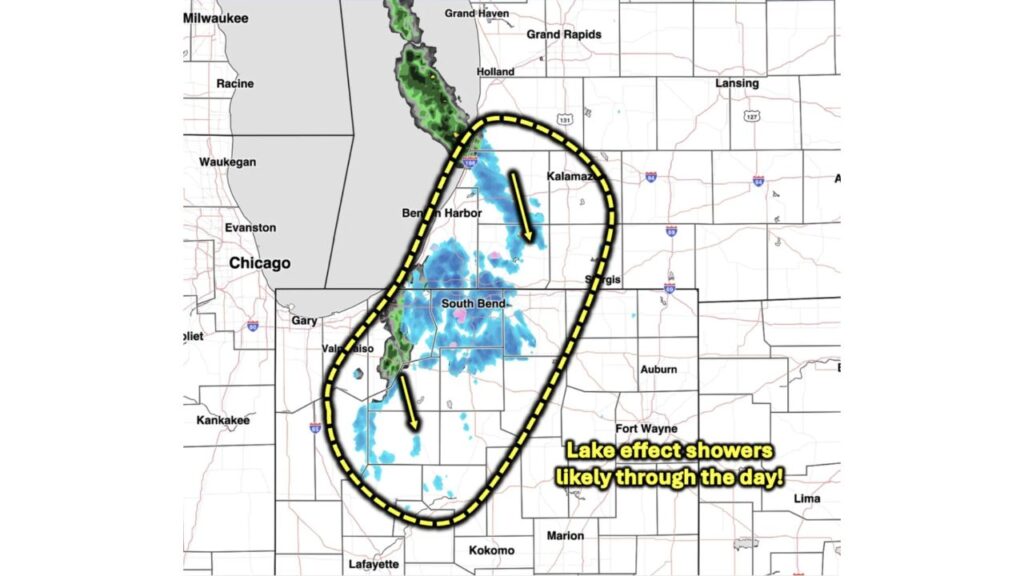
Radar Snapshot at 6:50 a.m. ET Saturday
| Area | Radar Activity |
|---|---|
| Lake Michigan, from Grand Haven to South Haven | Steady band of lake-effect rain |
| Benton Harbor and southwest Michigan | Light showers |
| Kalamazoo area | Scattered showers |
| Sturgis area | Light showers |
| South Bend | Widespread light showers |
| Valparaiso area | Narrow band of heavier showers |
| Areas south toward Lafayette and Kokomo | Scattered light showers |
Lake-Effect Showers Expected Through the Day
The highlighted area for lake-effect showers stretches from near Holland and South Haven in Michigan, south through Benton Harbor, Kalamazoo and Sturgis, and into northern Indiana around South Bend and Valparaiso. Showers are moving from north-northwest to south-southeast, following the wind off the lake.
Why “Blue” on Radar Doesn’t Always Mean Snow
Radar colors can be misleading at times. Some radar displays show blue when temperatures are near freezing, even if the precipitation reaching the ground is rain. On Saturday morning:
- Most of the blue shading was falling as rain
- A few isolated flurries could mix in through 9 a.m.
- Most people will see light rain for the day
Why It’s Rain Instead of Snow
The ground and lower atmosphere are still too warm for widespread snow in most areas. After a mild fall, Lake Michigan remains relatively warm, which can keep the air near the shoreline just above freezing.
A Different Story Than Friday’s Snow Hype
The rain-heavy reality comes after a debate over lake-effect snow forecasts for Chicago and northwest Indiana, when some viral maps showed up to 12 inches without accounting for melting. The National Weather Service had forecast 3 to 6 inches in parts of northwest Indiana and south of Chicago.
What to Expect for the Rest of Saturday
- Light rain showers on and off through the day
- Cool, damp conditions
- Gusty northwest winds off the lake
- Wet roads across southwest Michigan and northern Indiana
Travel Impacts
Roads should stay mostly wet rather than snowy. Still, drivers on I-94, I-196, I-80/90 and U.S. 131 should watch for:
- Spray from passing vehicles
- Reduced visibility in heavier bursts
- Slick spots early in the morning if flurries mix in
Tips for a Damp Day
- Grab an umbrella and rain jacket
- Slow down on wet roads
- Use headlights in showers
Outlook: Warmer Air Returns Next Week
After the cool, damp weekend, warmer than normal temperatures are expected to return to the Great Lakes heading into Thanksgiving week.
Stay with Bchssreport.com for the latest updates on this story.
About The Author
