
Remnants of Polo and a Low Near Phoenix Set to Wrap Heavy Moisture Into Colorado, With the Biggest Totals Favored From Denver and I-70 South
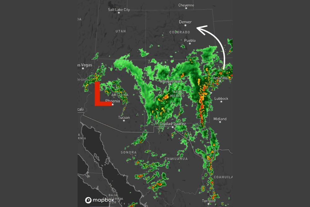
Denver, Colorado – A significant surge of moisture is heading toward Colorado, and the setup is coming together over the Desert Southwest. As of 8 p.m., the center of low pressure was located near Phoenix, Arizona, while moisture from the remnants of Polo was streaming out of northern Mexico into New Mexico and West Texas. All of that water is expected to get pulled into the storm’s circulation and wrap into Colorado from the south overnight and into the day on Wednesday.
Low Pressure Spinning Near Phoenix
The key player in this setup is an area of low pressure centered near Phoenix. This system is acting like an engine, pulling in moisture from the south and east and spinning it around its circulation. As the low slowly moves, it will steer that moisture north toward the Rockies.
Radar shows scattered showers and storms already developing around the low across parts of Arizona, including areas near Phoenix, Tucson, and toward Las Vegas.
Polo’s Remnants Pour Moisture Into New Mexico and West Texas
At the same time, the remnants of Polo are moving out of northern Mexico, sending deep tropical moisture north. Radar shows a large area of rain and embedded storms stretching across New Mexico, including areas near Albuquerque, and down toward Ciudad Juárez and the Chihuahua region.
Farther east, a long line of heavy rain and storms stretched through West Texas, running from near Midland and Lubbock north toward Amarillo and the Texas Panhandle. Some of the strongest cells in that band showed intense rainfall rates on radar.
Moisture Wraps Into Colorado From the South
As the low near Phoenix continues to spin, all of this moisture is expected to be pulled into the circulation and wrap north into Colorado. The moisture will arrive from the south, moving up through New Mexico and the eastern plains before spreading into central Colorado overnight and continuing through the day on Wednesday.
Some of the leading edge of this moisture was already reaching southern Colorado on radar, with scattered showers showing up near the New Mexico border and southeast of Pueblo.
Denver and I-70 South Favored for Heaviest Totals
The current thinking is that the heaviest precipitation will focus on areas along and south of Interstate 70, including the Denver metro area and points south. This would include communities along the Front Range such as Colorado Springs and Pueblo, as well as southern Colorado and parts of the southeastern plains.
Areas north of Denver and north of I-70 are currently expected to see lighter amounts, though that could change depending on how the storm moves.
Track Remains the Biggest Question
There is still high uncertainty regarding the exact track of the storm and how far north the heaviest precipitation will reach. Small shifts in the position of the low could make a big difference in who gets the most rain. If the system tracks farther north than expected, heavier totals could spread into northern Colorado. If it stays farther south, southern Colorado could end up with the bulk of the moisture while areas near Denver see less.
Residents across the state should keep checking for updates as the storm develops overnight and into Wednesday.
Flooding Concerns in Southern Colorado
With deep tropical moisture involved, heavy rain could lead to flooding concerns, especially in southern Colorado. Burn scar areas, including recent burn scars in the foothills, are particularly vulnerable. Even brief heavy rain over burned ground can lead to flash flooding and debris flows that move quickly downhill and into nearby roads and communities.
People living near burn scars, creeks, and low-lying areas should stay alert and be ready to move to higher ground if flash flood warnings are issued.
Travel Impacts Possible
Heavy rain could make travel difficult on major routes, including Interstate 25 and Interstate 70. Drivers should expect wet roads, reduced visibility, and possible ponding in low areas. In higher elevations, cooler temperatures could also lead to changing conditions depending on how cold the air becomes as the storm moves through.
Anyone planning to travel through the mountains or along the Front Range on Wednesday should check road conditions before heading out and allow extra travel time.
How to Prepare
Before the rain arrives, residents can take a few simple steps to prepare. Clear gutters and storm drains, secure outdoor items, and make sure phones are set to receive emergency alerts. Avoid parking in low-lying areas that could flood, and never try to drive through water-covered roads.
Updates to Come
With so much uncertainty in how far north the moisture will reach, the forecast could change as the storm evolves. Residents across Colorado should keep an eye on the latest updates overnight and throughout Wednesday.
For more Colorado weather updates and storm alerts, stay with bchssreport.com.