
National Hurricane Center Raises Invest 92L Development Chances to 80 Percent as Tropical Storm Isaias Looks Increasingly Likely This Week
Gulf Coast – The chances of a tropical system forming in the Gulf continue to climb. In its 2 a.m. Tuesday update, the National Hurricane Center slightly increased the odds of development for Invest 92L to 80 percent within the next 48 hours. That means it is becoming more likely that Tropical Storm Isaias will form this week. Overnight forecast models showed no drastic changes, and a track toward the northern Gulf Coast still appears to be the most likely outcome. However, the system’s eventual intensity remains a big question mark.
Development Chances Climb to 80 Percent
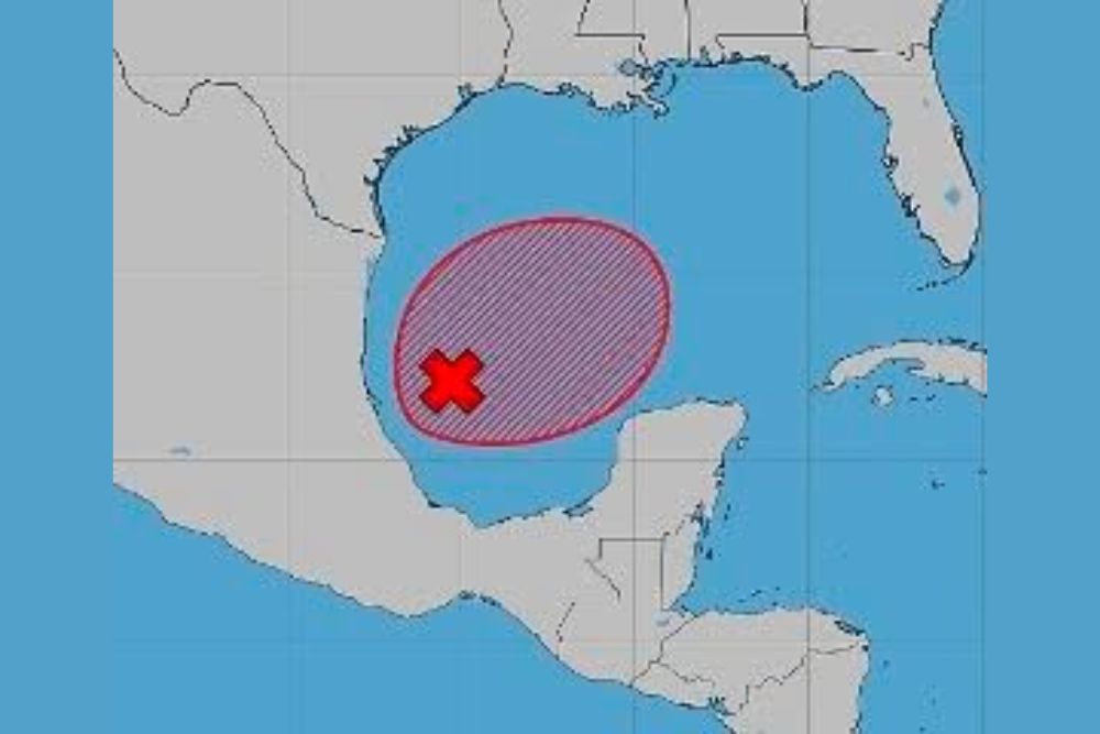
The latest outlook places a high chance of tropical development on Invest 92L, with an 80 percent chance of formation within 48 hours. The system is located in the southwestern Gulf, near the Bay of Campeche and off the coast of eastern Mexico.
The outlook area highlighted by the National Hurricane Center covers a large part of the western and southwestern Gulf, stretching from near the Mexican coast toward the central Gulf. This shows the general region where a tropical depression or storm is expected to form over the next couple of days.
Tropical Storm Isaias Could Form This Week
If Invest 92L develops into a tropical storm with sustained winds of at least 39 mph, it will be named Isaias, the next name on the 2026 Atlantic hurricane season list. With development chances now at 80 percent, forecasters say it is becoming increasingly likely that the season’s next named storm will form in the Gulf this week.
Hurricane Hunter aircraft are tentatively scheduled to investigate the system, which will give forecasters important information about its organization, wind speeds, and pressure.
No Drastic Changes in Overnight Models
Forecast models run overnight did not show any major changes from the previous runs. That consistency gives forecasters a bit more confidence in the general idea that the system will develop and eventually move toward the northern Gulf Coast.
Earlier model runs showed the system approaching the coast somewhere between eastern Louisiana and the western Florida Panhandle on Friday into Saturday. While the exact track could still shift, the northern Gulf Coast remains the most likely area for impacts.
Track Toward the Northern Gulf Coast
The current thinking is that the system will drift slowly in the southwestern Gulf before turning north later in the week. A trough moving across the central United States is expected to help steer the system toward the northern Gulf Coast.
Areas that should pay close attention include Louisiana, Mississippi, Alabama, and the Florida Panhandle, including cities such as New Orleans, Gulfport, Biloxi, Mobile, Gulf Shores, Pensacola, and Destin. Residents in Texas and the rest of Florida should also keep an eye on updates, since tracks can change before a storm fully forms.
Intensity Still a Big Question Mark
While the track forecast is becoming a bit clearer, how strong the system becomes remains highly uncertain. Some specialized hurricane models have shown the system strengthening into a hurricane before reaching the coast, while other guidance suggests it could stay weaker.
One of the main factors working against strengthening is wind shear across the northern Gulf later in the week. With the jet stream dipping unusually far south for early October, strong upper-level winds could tilt and disrupt the storm as it approaches the coast. On the other hand, the warm waters of the Gulf could provide plenty of energy if wind shear is weaker than expected.
Heavy Rain Likely No Matter What
Even if the system does not become a strong storm, heavy rain appears likely across parts of the northern Gulf Coast later this week and into the weekend. Much of the region has already seen heavy rain recently, which could make flooding more likely if additional heavy rain falls.
Coastal areas could also deal with rough surf, dangerous rip currents, and possible coastal flooding, especially if the system strengthens.
A Quiet Season Could Be Changing
The 2026 Atlantic hurricane season has been unusually quiet so far, with no hurricanes forming this year due in part to a strong El Niño pattern. If Isaias forms and strengthens, it could become one of the most significant tropical systems of the season for the United States.
Prepare Now, Not Later
With a tropical system increasingly likely in the Gulf, now is the time for residents along the coast to review hurricane plans. Make sure emergency kits are stocked with water, food, medications, flashlights, batteries, and important documents. Residents should also know their evacuation zones and have a plan in case officials issue evacuation orders.
Boaters and anyone with plans on the Gulf this week should keep a close eye on marine forecasts.
Stay Tuned for Updates
The forecast will become clearer as the system develops and Hurricane Hunters gather more data. Residents should continue to follow updates from the National Hurricane Center and local officials over the coming days.
For more Gulf Coast tropical updates and hurricane season coverage, stay with bchssreport.com.