
Hurricane Isaias Brings a Beneficial Soaking Rain but Limited Impacts to the Carolinas as the Storm Tracks Well to the West
Charlotte, North Carolina – Hurricane Isaias is a powerful Category 2 storm in the Gulf, but for the Carolinas, it is shaping up to be more of a beneficial soaking rain than a damaging storm. Isaias is expected to make landfall along the central Gulf Coast near Mobile and Pensacola on Friday evening before turning north and weakening quickly over the weekend. Its track keeps the center well to the west of the Carolinas, meaning impacts here should be limited, with steady rain, some gusty winds, and only minor flooding at worst.
Landfall Friday Evening, Then Rapid Weakening
Isaias is forecast to come ashore near the Alabama and Florida Panhandle coast on Friday evening as a hurricane. After landfall, it will turn north and weaken quickly as it moves through Alabama and into Tennessee over the weekend.
By Saturday morning, Isaias is expected to weaken to a tropical storm. By Sunday morning, it should be just a weak area of low pressure with winds around 30 mph near the Tennessee and Kentucky border.
Center Stays Well to the West
That track keeps the storm’s center far west of North and South Carolina. While the region will feel some of the storm’s effects, especially rain, the strongest winds and most dangerous impacts are expected to stay along the Gulf Coast and in parts of Alabama, Georgia, Mississippi, and Tennessee.
Rain: The Main Story and Mostly Good News
Rain will be the biggest impact from Isaias in the Carolinas, and it is mostly good news. The rain is expected to fall over a 24 to 36-hour period from Saturday into Sunday, arriving steadily rather than all at once. That gives the ground more time to soak it up.
Most areas have a very high chance of getting at least 1 inch of rain. The odds of 1 inch or more are around 90 to 100 percent from the mountains through the Hickory area and the western Piedmont.
Low Odds of Heavy Totals
While heavier totals are possible in a few spots, the chances are low. The odds of 4 inches or more are only about 20 to 25 percent, even in the wettest areas along the foothills and the Blue Ridge Escarpment, including Hendersonville, Lake Lure, and Marion.
Around Gastonia and Charlotte, the chance of 4 inches or more is under 10 percent. Overall, this looks like a beneficial soaking, not a flood event.
Wind: Gusty at Times, Mainly in the Mountains
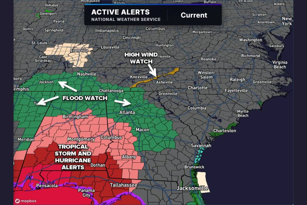
Winds will be gusty at times, especially at higher elevations. A High Wind Watch is in effect along the Tennessee border in the mountains of western North Carolina, including areas near Asheville and the higher terrain toward Knoxville.
Elsewhere, conditions should be breezy, with the chance of a few small limbs coming down. Widespread tree damage or power outages are not expected in the Charlotte area.
Where the Bigger Concerns Are
The more serious impacts from Isaias are expected well south and west of the Carolinas. Flood Watches are in effect for parts of Georgia, including the Atlanta area, along with portions of Tennessee, Alabama, and Mississippi.
Tropical Storm and Hurricane alerts are in place along the Gulf Coast and extend into southern Alabama, southwest Georgia, and the Florida Panhandle, including areas near Pensacola, Panama City, Dothan, Montgomery, and Tallahassee. None of these alerts currently extend into the Carolinas.
Bottom Line for the Carolinas
The worst-case scenario for the Carolinas looks like gusty winds and periods of heavy rain, with minor flooding possible in a few low-lying or poor drainage areas. No widespread flooding or damage is expected. This is not expected to be an extreme, medium-impact, or high-impact event. Any negative effects should be low impact.
Tips for the Weekend
Even with limited impacts, residents should still take a few simple steps before the rain arrives. Clean gutters and storm drains, especially with leaves starting to fall. Secure lightweight outdoor items, such as decorations and patio furniture, in case of gusty winds.
Drivers should be prepared for wet roads and reduced visibility during heavier rain, and should never drive through flooded roads. Anyone heading into the mountains this weekend should be ready for strong winds, especially along ridges and higher elevations.
Welcome Rain for Dry Areas
After a dry stretch, the rain will be helpful for lawns, gardens, farms, and water supplies. A steady, soaking rain is one of the best ways to improve soil moisture without causing major flooding.
Keep Checking for Updates
Forecasters will continue watching Isaias through the weekend. If the track or rainfall forecast changes, updates will follow. For now, think of Isaias as a good, soaking rain for the Carolinas.
For more Carolinas weather updates and tropical coverage, stay with bchssreport.com.