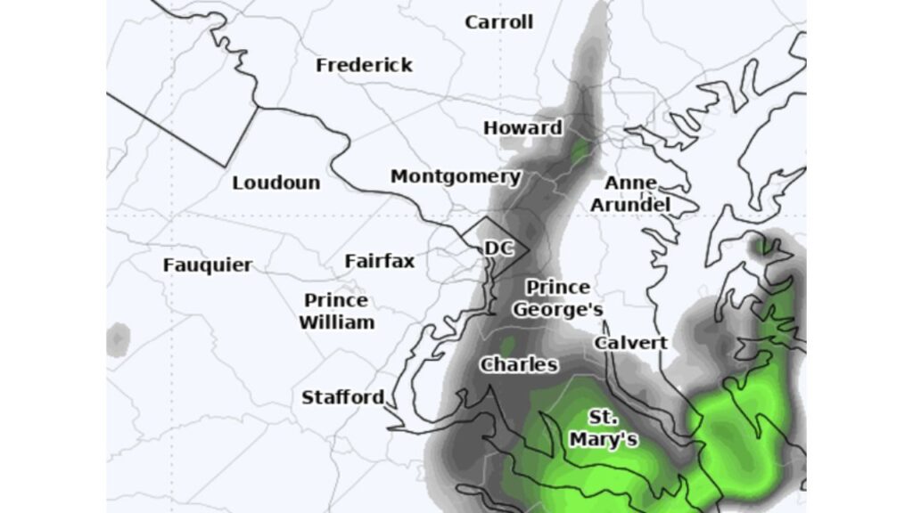
Washington, D.C. Mostly Dodges Sunday’s Coastal Rain as Only a Few Late-Day Showers Expected, While Southern Maryland and St. Mary’s County Get the Wettest Weather
WASHINGTON, D.C. — After days of uncertainty, the forecast for Sunday, November 22, 2026, is finally coming into focus for the Washington, D.C. region. The area will probably not see much measurable rain, although a few showers could pass through at times, mainly during the late afternoon or evening.
Forecasters said they had been frustrated by a low-confidence forecast for several days, as computer models flip-flopped between heavy and light rain amounts.
Why the Forecast Was So Tricky
The uncertainty came from a developing coastal low off the Southeast coast. Small shifts in the storm’s track made a big difference for D.C.:
- A track closer to the coast would have brought heavier rain inland
- A track farther offshore, which now looks more likely, keeps most of the rain east and south of the city
Where the Showers Are Most Likely
A simulated radar forecast for Sunday shows a narrow band of showers stretching north to south through the region, with the heaviest rain in southern Maryland:
| Area | Expected Conditions Sunday |
|---|---|
| St. Mary’s County | Steadier, heavier rain at times |
| Calvert County and the lower Eastern Shore | Areas of moderate rain |
| Charles County | Showers, some briefly heavier |
| Prince George’s County | Scattered light showers |
| Washington, D.C. | A few showers possible, mainly late in the day |
| Howard County and eastern Montgomery County | Light, scattered showers |
| Anne Arundel County | Isolated showers |
| Fairfax, Prince William, Loudoun and Fauquier | Mostly dry |
| Frederick and Carroll counties | Mostly dry |
| Stafford County | Showers near the Potomac River |
Southern Maryland Gets the Most Rain
The wettest weather in the region is expected over St. Mary’s County and parts of Calvert and Charles counties, closer to the Chesapeake Bay and the coastal storm. These areas could see steadier rain for a time on Sunday.
Northern and Western Suburbs Stay Mostly Dry
Areas north and west of the city, including Loudoun, Fauquier, Frederick and Carroll counties, are expected to stay mostly dry, with only a stray shower possible.
Coastal Storm Brings Bigger Impacts Elsewhere
While D.C. mostly misses out, the same coastal storm is bringing:
- 0.50 to 1 inch of rain to the Carolina and Mid-Atlantic coasts
- 1 to 2 inches to the Northeast coast, including Boston, into Monday
- Gusty winds, rough surf, rip currents and coastal flooding along the East Coast
The storm had a small chance of becoming Kyle, but the National Hurricane Center dropped those odds to just 10%.
More Rain Possible Before Thanksgiving
Sunday’s light showers may not be the end of the wet weather. Forecasters are watching for heavy rain across the East, including the Mid-Atlantic, on Wednesday and Thursday, November 25 and 26, right in the middle of Thanksgiving travel.
Tips for Sunday Plans
- Keep an umbrella handy if heading out late in the day
- Expect wet roads in southern Maryland
- Check the radar before evening outdoor plans
- Plan ahead for possible rain during Thanksgiving travel
Outlook: Mostly Dry Sunday in D.C.
For most of the D.C. area, Sunday should be cloudy with only a few showers, a much lighter outcome than some earlier forecasts suggested.
Stay with Bchssreport.com for the latest updates on this story.
About The Author
