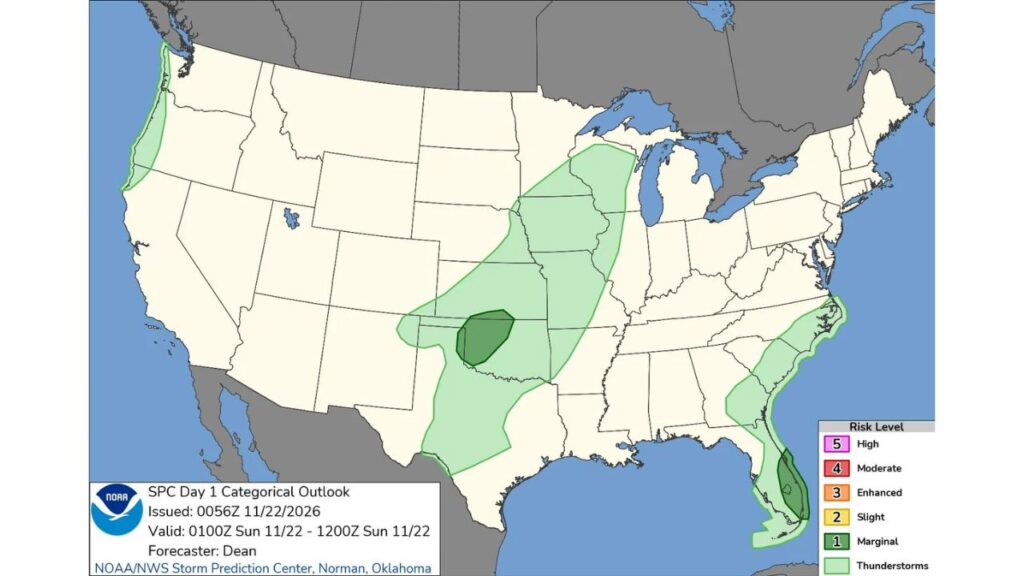
Southeast Florida and Western Oklahoma Under Level 1 Severe Storm Risk Saturday Night Into Sunday Morning as Storms Stretch From Texas to Wisconsin
OKLAHOMA CITY, OKLAHOMA — Two very different parts of the country were placed under a Level 1 (Marginal) risk for severe thunderstorms overnight Saturday, November 21, into Sunday morning, November 22, 2026: southeast Florida and western and northern Oklahoma.
The updated outlook from the NOAA Storm Prediction Center came just hours after the National Weather Service confirmed a tornado over Kings Point, near Delray Beach, Florida.
Outlook Details
| Detail | Information |
|---|---|
| Issued | 6:56 p.m. CST Saturday, November 21 |
| Valid | 7 p.m. CST Saturday through 6 a.m. CST Sunday, November 22 |
| Forecaster | Dean, Storm Prediction Center, Norman, Oklahoma |
| Highest risk | Level 1 (Marginal) |
| Risk areas | Southeast Florida, western and northern Oklahoma |
Risk Area One: Southeast Florida
The Florida risk zone covered the southeast coast, including parts of:
- Indian River and St. Lucie counties
- Martin County
- Palm Beach County, including West Palm Beach, Boca Raton and Delray Beach
- Areas near the east side of Lake Okeechobee
This same area had been under a Tornado Watch until 10 p.m. Saturday, covering more than 2 million people.
Confirmed Tornado Near Delray Beach
Earlier Saturday evening, a tornado was confirmed over Kings Point, west of Delray Beach. Residents in nearby communities, including The Bridges, Lotus and Huntington Lakes, reported uprooted trees, though no injuries were reported. The National Weather Service is expected to survey the damage on Sunday.
Risk Area Two: Western and Northern Oklahoma
The second Marginal Risk covered a section of western and northern Oklahoma, near the Texas Panhandle border and stretching east toward north-central Oklahoma. Storms in this area could bring:
- Isolated damaging wind gusts
- Small to marginally severe hail
- Frequent lightning
What a Level 1 Marginal Risk Means
A Marginal Risk is the lowest of the Storm Prediction Center’s five severe weather levels. It means isolated severe storms are possible, but they should be limited in number, duration or strength.
General Thunderstorms Across a Wide Area
Outside the two risk zones, general thunderstorms were possible across:
| Region | Areas Included |
|---|---|
| Southern Plains | West and central Texas, Oklahoma and southern Kansas |
| Midwest | Eastern Kansas, Missouri, Iowa, Illinois and southern Wisconsin |
| Southeast coast | Coastal Georgia, South Carolina and North Carolina |
| Florida | Much of the peninsula and the Florida Keys |
| Pacific Northwest | Coastal Washington and Oregon |
These storms were not expected to be severe but could still bring lightning and heavy rain.
Two Systems, One Busy Night
The Florida storms were tied to a developing coastal low off the Southeast, which is expected to bring rain from the Carolinas to the Northeast into Monday. The Oklahoma storms were linked to a separate system moving across the southern Plains.
Severe Weather Safety Tips
- Keep phone alerts on overnight
- Know your safe place in case of a warning
- Avoid driving through heavy downpours
- Stay away from downed trees and power lines
Outlook: Storms Wind Down Sunday Morning
The severe threat was expected to ease by early Sunday morning, but forecasters are watching for more storms and heavy rain across the East ahead of Thanksgiving.
Stay with Bchssreport.com for the latest updates on this story.
About The Author
