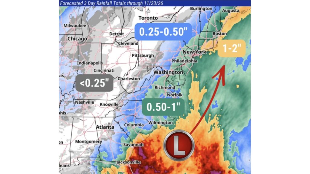
Coastal Low Brings Up to 2 Inches of Rain to Boston and the Northeast Coast Through Monday, While the Carolina and Mid-Atlantic Coasts Get Up to an Inch
BOSTON, MASSACHUSETTS — A developing coastal low is spreading rain up the East Coast this weekend, from the Carolinas to the Northeast, with wet weather continuing into Monday, November 23, 2026.
The heaviest totals, up to 1 to 2 inches, are expected along the Northeast coast, including the Boston area and coastal New England.
Forecast Rain Totals Through Monday
The three-day rainfall forecast through Monday, November 23, shows totals climbing from inland areas to the coast:
| Area | Forecast Rainfall |
|---|---|
| Northeast coast, including Boston, Cape Cod and coastal Maine | 1 to 2 inches |
| Carolina and Mid-Atlantic coasts, including Wilmington, Norfolk and Richmond | 0.50 to 1 inch |
| New York City, Philadelphia and Washington | About 0.50 to 1 inch |
| Farther inland, including upstate New York and central Pennsylvania | 0.25 to 0.50 inch |
| Columbia, Savannah and Atlanta areas | Light amounts |
| Ohio Valley, including Pittsburgh, Cincinnati and Charleston, W.Va. | Under 0.25 inch |
| Midwest, including Chicago, Detroit and Indianapolis | Under 0.25 inch |
How the Coastal Low Moves
The low-pressure system is forming off the Southeast coast, east of Savannah and Jacksonville. From there, it is expected to track north-northeast, running parallel to the coast toward New England.
As it moves, it pulls Atlantic moisture onshore, bringing the heaviest rain to areas closest to the ocean.
Northeast Coast Sees the Highest Totals
The wettest zone stretches along the coast from Long Island and southern New England to Boston and up into coastal Maine near Augusta. Totals of 1 to 2 inches could lead to:
- Ponding on roads and highways
- Minor urban flooding in low-lying areas
- Slow commutes on Monday morning
Carolinas and Mid-Atlantic: Half an Inch to an Inch
Along the Carolina coast and the Mid-Atlantic, including Wilmington, Norfolk and Richmond, rain totals of 0.50 to 1 inch are expected. The Delmarva Peninsula and coastal Virginia may sit near the higher end of that range.
Lighter Rain Inland
Farther from the coast, totals drop off quickly. Areas like upstate New York and central Pennsylvania may see 0.25 to 0.50 inch, while much of the Ohio Valley and Midwest gets less than a quarter inch.
A Prelude to a Wetter Thanksgiving Week
This coastal low is just the first round of rain for the East this week. Forecasters are also watching for heavy rain from the Southeast to New England on Wednesday and Thursday, November 25 and 26, right in the middle of Thanksgiving travel.
Travel Tips for Sunday and Monday
- Allow extra time for the Monday morning commute
- Slow down on wet roads, especially on I-95
- Avoid flooded streets and underpasses
- Check flight status at Boston, New York and Philadelphia airports
Outlook: Rain Exits Monday, More Coming Midweek
The coastal low is expected to move away by Monday night, but travelers should keep watching the forecast as another storm system approaches ahead of Thanksgiving.
Stay with Bchssreport.com for the latest updates on this story.
About The Author
