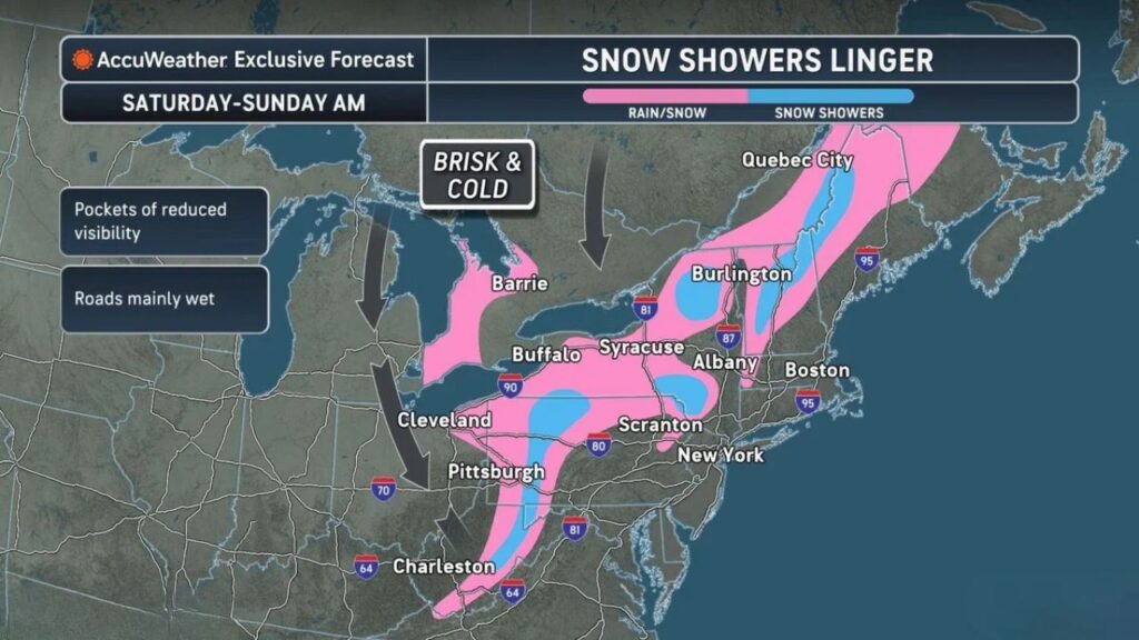
Upstate New York, Pennsylvania and the Appalachians Keep Snow Showers Into Sunday Morning as Brisk, Cold Winds Follow the Northeast Storm, While Roads Stay Mostly Wet
BUFFALO, NEW YORK — The storm that brought rain to major Northeast cities and wet snow to areas farther inland is winding down, but snow showers will linger across parts of the region from Saturday, November 14, 2026, into Sunday morning.
Brisk, cold winds blowing from the northwest will keep things feeling wintry, especially across upstate New York, Pennsylvania and the Appalachian Mountains.
Weekend Timeline
| Time | What to Expect |
|---|---|
| Saturday | Rain and snow showers mix inland, snow showers in the mountains |
| Saturday night | Colder air deepens, more snow showers at higher elevations |
| Sunday morning | Snow showers taper, brisk and cold |
Where Snow Showers Will Linger
The heaviest snow showers are expected in higher elevations, including:
| Area | Expected Conditions |
|---|---|
| Adirondacks, New York | Snow showers |
| Green Mountains of Vermont and northern New Hampshire | Snow showers |
| Catskills and Poconos area | Snow showers |
| Western Pennsylvania mountains | Snow showers |
| West Virginia and Virginia mountains | Snow showers |
Rain and Snow Mix Across a Wide Area
A broader zone of mixed rain and snow covers:
- Western and central New York, including Buffalo and Syracuse
- Northern Ohio, including Cleveland
- Western Pennsylvania, including Pittsburgh
- Northeast Pennsylvania, including Scranton
- The Albany area
- Parts of West Virginia, including areas east of Charleston
- Interior Maine, New Hampshire and Vermont
- Southern Ontario and Quebec
Big Cities Mostly Done With the Storm
Major coastal cities like New York and Boston are expected to stay mostly outside the lingering snow shower zone, with the storm’s rain ending and colder, breezy conditions moving in.
Brisk and Cold Winds From the Northwest
Cold air pouring in from Canada behind the storm will bring brisk northwest winds across the Great Lakes and Northeast. These winds help feed lake-effect and upslope snow showers off Lake Erie and Lake Ontario and into the mountains.
Travel Impacts: Mainly Wet Roads
Forecasters say roads should be mainly wet, thanks to warm ground temperatures after a mild fall. However, drivers should still watch for:
- Pockets of reduced visibility in heavier snow showers
- Slushy spots at higher elevations
- Slick bridges and overpasses early Sunday
Key routes that could see snow showers include I-90, I-81, I-87, I-80 and I-64 through the mountains.
Part of the Season’s First Widespread Mountain Snow
This weekend’s snow showers follow the first widespread Appalachian snowfall of the season, which brought up to a foot or more to the Catskills and snow-covered ground to ski country west of Washington, D.C.
Tips for Weekend Travel
- Slow down in snow showers and low visibility
- Use headlights in rain and snow
- Check road conditions before mountain travel
- Dress in layers for the brisk winds
Outlook: Cold Lingers, Then Milder Air Returns
After the cold weekend, forecasts show warmer than normal temperatures returning to much of the Great Lakes and Northeast later in the week ahead of Thanksgiving.
Stay with Bchssreport.com for the latest updates on this story.
About The Author
