
Big October Cooldown Coming to Northern Ohio With Highs in the 40s, Multiple Frost Nights, and Even a Few Snowflakes Possible
Northern Ohio – Mother Nature may be getting ready to remind Northern Ohio that winter is not that far away. Long-range forecast models are becoming increasingly consistent in showing a significant pattern change between October 16 and October 20, bringing a serious fall chill to the region. Daytime highs could struggle to climb out of the 40s and low 50s, overnight lows could drop into the 30s, and there is even a chance a few snowflakes, graupel, or sleet could mix in with showers in some areas.
A Significant Pattern Change Ahead
After a stretch of relatively mild October weather, the pattern is expected to shift dramatically later next week. Colder air from Canada is forecast to spill south into the Great Lakes and Ohio Valley, replacing the warmth with much more fall-like, and at times winter-like, conditions.
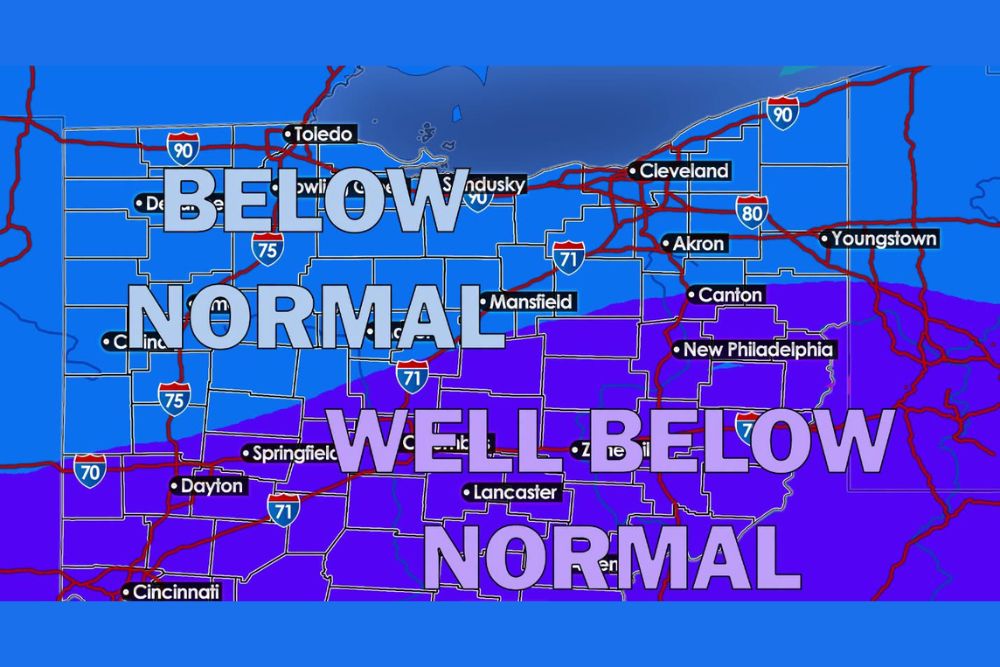
Forecast maps show below normal temperatures across Northern Ohio, including Toledo, Sandusky, Cleveland, Akron, Youngstown, and Mansfield. Farther south, temperatures are expected to be well below normal across central and southern Ohio, including Columbus, Springfield, Dayton, Lancaster, Zanesville, New Philadelphia, and toward Cincinnati.
Daytime Highs in the 40s and Low 50s
During the cooler stretch, daytime highs may struggle to get out of the 40s and low 50s, generally ranging from 45 to 55 degrees. That is well below normal for mid to late October, when average highs in Northern Ohio are usually in the low 60s.
For many residents, it will be the coldest stretch of the season so far, making it feel more like November than October.
Overnight Lows in the 30s
Overnight lows are expected to fall into the 30 to 40-degree range, raising the potential for multiple nights of frost and even freezing temperatures. Rural areas, valleys, and spots away from Lake Erie will be most likely to see the coldest readings.
Gardeners should be ready to protect sensitive plants or bring potted plants indoors. For many areas, this stretch could mark the end of the growing season.
A More Active Pattern
Unlike the quiet, dry weather that has been in place recently, this cooler stretch could also bring a more active pattern. Multiple disturbances are expected to move through the Great Lakes, bringing chances for showers and cloudy skies at times.
With cold air flowing over the still-mild waters of Lake Erie, some areas near the lake could also see lake-enhanced showers, especially in Northeast Ohio near the snowbelt east of Cleveland.
Snowflakes, Graupel, or Sleet Possible
Here is where things get interesting. Depending on how much cold air arrives and the timing of these disturbances, a few snowflakes, graupel, or even sleet could mix in with showers across parts of the region.
Graupel is a type of precipitation that looks like tiny, soft pellets of snow. It forms when supercooled water droplets freeze onto falling snowflakes. It often falls during chilly showers in the fall and spring.
No Accumulating Snow Expected
Before anyone starts digging out the snow shovels, it is important to note that this is still more than a week away, and no one is expected to see accumulating snow. Any snowflakes would likely be brief and mixed with rain, especially during the coldest parts of the day or night.
This is simply another reminder that winter is getting closer.
Mild October Weather Has an Expiration Date
One thing is becoming increasingly clear: the stretch of relatively mild October weather may soon come to an end. Before the cold air arrives, temperatures are expected to stay warmer than normal, so residents may want to take advantage of the pleasant weather while it lasts.
Time to Prepare for Colder Weather
With colder temperatures on the way, now is a great time to get ready. Residents should check furnaces and replace air filters, clean gutters before leaves fully fall, and disconnect garden hoses to prevent frozen pipes. It is also a good time to pull out winter coats, hats, and gloves.
Drivers may want to make sure their vehicles are ready for cold weather, including checking tires, batteries, and windshield wipers.
Forecast Still Being Fine-Tuned
Since the pattern change is still more than a week away, details on timing, temperatures, and precipitation could change. Residents should keep checking for updates as the cooler air gets closer.
For more Northern Ohio weather updates and seasonal forecasts, stay with bchssreport.com.