
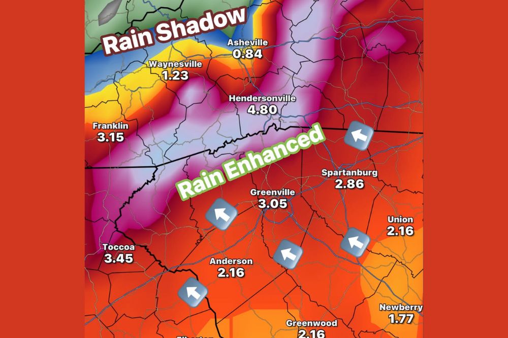
Same Storm, Big Difference in Rainfall as Mountains Squeeze Out 4 to 8 Inches on Upslope Sides While Asheville Sits in a Rain Shadow
Greenville, South Carolina – As moisture from Isaias streams into the Southeast this weekend, the mountains of western North Carolina and the Upstate of South Carolina are about to show just how much terrain can affect rainfall. Forecast maps reveal a dramatic difference in rain totals between the upslope and downslope sides of the mountains. Communities on the southern and eastern-facing slopes could see 4 to 8 inches of rain, while areas tucked behind the mountains, such as Asheville, may get less than an inch. The Upstate is expected to see generally 2 to 4 inches, and some flooding issues are possible, especially in the mountains.
How Mountains Change Rainfall Totals
Moisture flowing in from both the Atlantic and the Gulf is being pushed northwest toward the mountains. When that moist air reaches the southern and eastern-facing slopes of the Blue Ridge, it is forced to rise. As air rises, it cools, and the moisture condenses into clouds and rain. This process, known as upslope enhancement, can significantly increase rainfall on the side of the mountains facing the incoming moisture.
On the opposite side of the mountains, the air sinks as it flows downhill. Sinking air warms and dries out, which reduces rainfall. This creates what is known as a rain shadow, where totals can be much lower even though the same storm is passing through.
Rain Enhanced Along the Blue Ridge Escarpment
The heaviest rain is expected along the Blue Ridge Escarpment, where the mountains rise sharply from the Upstate. Hendersonville is forecast to receive around 4.80 inches of rain, one of the highest totals in the region.
Farther southwest, Toccoa, Georgia could pick up about 3.45 inches, while Franklin, North Carolina is forecast to see around 3.15 inches. Some locations along the steepest south and east-facing slopes could see 4 to 8 inches, especially in areas where moisture is repeatedly forced upward.
Asheville in the Rain Shadow
In contrast, Asheville sits on the downslope side of the mountains and is forecast to receive only about 0.84 inches of rain. Waynesville is also expected to see a lower total, near 1.23 inches.
That means communities only a short drive apart could see several inches of difference in rainfall from the same storm.
Upstate Expected to See 2 to 4 Inches
Across the Upstate of South Carolina, rain totals are expected to fall mostly in the 2 to 4-inch range. Greenville is forecast to receive about 3.05 inches, while Spartanburg could see around 2.86 inches.
Anderson, Union, and Greenwood are expected to pick up about 2.16 inches, while Newberry is forecast to receive around 1.77 inches. Areas closer to the mountains are expected to see higher amounts, while totals gradually drop farther southeast.
Flooding Concerns in the Mountains
With several inches of rain possible on the upslope side of the mountains, flooding issues are a concern. Steep terrain allows water to run off quickly into creeks, streams, and rivers, which can lead to rapid rises in water levels.
Areas at greatest risk include mountain streams, low-lying roads, and communities in narrow valleys along the escarpment. Landslides and rockslides are also possible in steep areas when soil becomes saturated.
Residents and visitors in the mountains should stay alert, avoid driving through flooded roads, and be ready to move to higher ground if flooding develops.
Rain Falls Over 24 to 36 Hours
The rain is expected to fall over a 24 to 36-hour period from Saturday into Sunday. Because it is spread out over time, many areas, especially in the Upstate and Piedmont, should be able to absorb the rain without major flooding. However, heavier bursts of rain could still cause ponding on roads and minor flooding in poor drainage areas.
Gusty Winds in Higher Elevations
Along with the rain, gusty winds are expected at times, especially in the higher elevations of the mountains. A High Wind Watch has been issued along the Tennessee border, where stronger gusts could bring down limbs and cause isolated power outages.
Beneficial Rain for Many Areas
While flooding is possible in some mountain areas, the rain will also be beneficial for much of the region after a dry stretch. Lawns, gardens, farms, and water supplies will benefit from a good soaking.
Stay Weather Aware This Weekend
Anyone traveling through the mountains this weekend should check road conditions before heading out and be prepared for heavy rain, gusty winds, and reduced visibility.
For more Upstate and Western North Carolina weather updates, stay with bchssreport.com.