
Isaias Remnants Could Bring Sunday Soaker to the Ohio Valley as Latest Models Shift Heaviest Rain Farther West and Arrive Earlier
Ohio Valley – The forecast for Sunday is getting more interesting as Isaias approaches landfall along the northern Gulf Coast. The latest model guidance shows a few important trends emerging, including a slightly earlier arrival time and a possible westward shift in the axis of heaviest rain. One thing is becoming increasingly clear: Sunday is shaping up to be a wet day across much of the Ohio Valley and surrounding region, with periods of potentially heavy rain in some locations.
The Storm Track
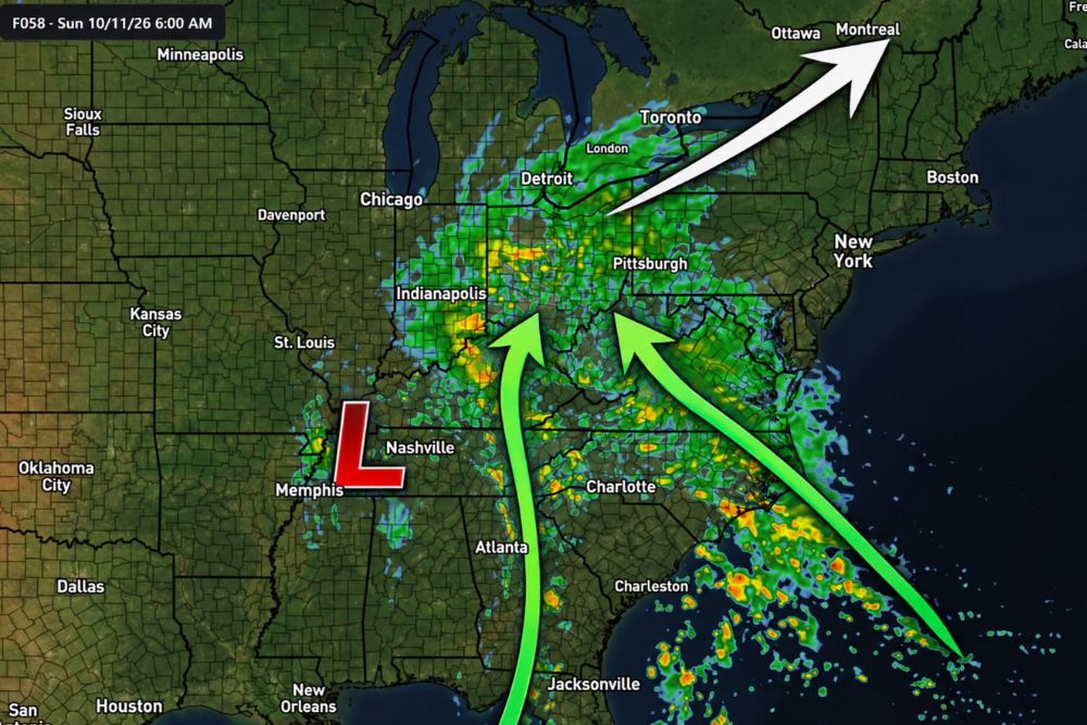
After making landfall, the tropical system is expected to track northward through the Deep South before a mid-level jet stream helps steer it northeastward and eventually eastward. Forecast guidance for early Sunday morning, October 11, shows the center of low pressure near the Memphis and Nashville area in western Tennessee, with rain already spreading north into Kentucky, Indiana, and Ohio.
From there, the system is expected to continue northeast toward the Great Lakes and eventually into southeastern Canada, near Toronto, Ottawa, and Montreal.
Arriving a Few Hours Earlier
The latest guidance suggests the system could arrive a few hours earlier than previously expected. While that may not sound like a big deal, even a small change in timing can have a significant impact on where the heaviest rain sets up. Earlier arrival could also mean rain begins overnight Saturday into early Sunday morning in some areas, rather than later in the day.
Heaviest Rain Shifting Farther West
Some of the latest model runs are also beginning to shift the axis of heaviest rain a little farther west. That trend is being watched very closely, especially for communities that previously appeared to be on the western edge of the heavier rain. Areas in Indiana, western Ohio, and central Kentucky, including communities near Indianapolis, could see more rain than earlier forecasts suggested if this trend continues.
At the same time, areas farther east, including eastern Ohio and western Pennsylvania near Pittsburgh, are still expected to see widespread rain.
Impressive Tropical Moisture From Two Sources
What really stands out about this system is the amount of tropical moisture it will have access to. Moisture is being transported northward from both the Gulf and the Atlantic.
One stream of moisture is moving north from the Gulf through Alabama, Georgia, and Tennessee, while another is flowing in from the Atlantic across the Carolinas and into the Appalachians. These two moisture plumes are expected to come together over the Ohio Valley, fueling widespread rainfall and periods of heavy rain.
Will the Westward Trend Continue?
That is the million-dollar question. Forecasters will be watching model runs over the next day to see whether the westward shift becomes a consistent trend or turns out to be model noise, which happens when forecasts bounce around from one run to the next. By Saturday afternoon, there should be a better idea of where the heaviest rain will set up.
Sunday Will Be Wet Either Way
No matter where the heaviest band ends up, Sunday looks wet for much of the region. Many communities can expect steady rain, with some areas seeing heavy downpours at times. Earlier forecasts showed some areas picking up 1 to 2 inches of rain, and that remains possible depending on the final track.
Flooding Concerns
With tropical moisture in place, rain could fall heavily over short periods, which may lead to ponding on roads, rising creeks and streams, and localized flooding in low-lying and urban areas. Fallen leaves can also clog storm drains this time of year, making street flooding more likely.
Drivers should avoid flooded roads and remember that it only takes a small amount of moving water to sweep a vehicle away.
Impact on Weekend Plans
Anyone with outdoor plans on Sunday should be ready for wet weather. That includes football games and tailgates, youth sports, fall festivals, and pumpkin patch visits. It may be best to schedule outdoor activities for Saturday, which looks drier for much of the region.
Prepare Before the Rain Arrives
Before Sunday, residents should clean gutters and storm drains, secure outdoor decorations, and make sure rain gear is ready. Anyone in flood-prone areas should keep an eye on alerts and be ready to act if flooding develops.
More Updates to Come
With the track, timing, and rainfall placement still being fine-tuned, residents should continue checking for updates through Saturday.
For more Ohio Valley weather updates and tropical coverage, stay with bchssreport.com.