
Confidence Grows for California’s First Notable Mountain Snow of the Season as a Strong Cold Front Targets the Sierra and Possibly Big Bear
California – Confidence is growing that colder air arriving this weekend into early next week could bring the first notable higher-elevation snow chances of the season to parts of California. A strong cold front is expected to sweep across the state, dropping temperatures sharply and lowering snow levels in the Sierra Nevada. Farther south, snow could even become possible in the higher mountains of Southern California, including the Big Bear area, depending on how the cold air and moisture line up.
Strong Cold Front Arrives Sunday Into Monday
Across the Sierra Nevada, a strong cold front is expected to bring a substantial temperature drop from Sunday into Monday. As colder air pushes in, snow levels could fall into the 5,000 to 6,000-foot range at times.
That would be low enough for snow showers around some of the higher Sierra passes and the mountains surrounding Lake Tahoe. Travelers heading over routes such as Interstate 80 near Donner Pass and U.S. Highway 50 near Echo Summit should keep an eye on the forecast, as conditions could change quickly once the colder air arrives.
Snow Likely Along the Sierra Crest
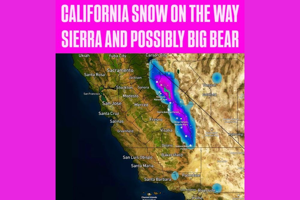
Forecast guidance shows snow focused along the spine of the Sierra Nevada, stretching from the Tahoe region and areas west of Carson City south through Yosemite National Park, the Sierra National Forest, Kings Canyon National Park, and Sequoia National Park.
The highest elevations along the Sierra crest have the best chance of seeing accumulating snow. At this point, at least light accumulations are probable to likely in the Sierra, especially at higher elevations.
Big Bear and Southern California Mountains
Farther south, snow could even become possible in the higher mountains of Southern California, including the San Bernardino Mountains near Big Bear. Forecast maps also show the potential for light precipitation in the mountains north of Los Angeles, near the Tehachapi and Tejon Pass areas, as well as the higher terrain near Riverside.
Whether that precipitation falls as snow or rain will depend on how much cold air overlaps with the incoming moisture. If the cold air arrives at the right time, the highest peaks could see their first snowflakes of the season.
Tropical Moisture From Rachel
Part of the moisture for this system could come from Rachel, a tropical system in the eastern Pacific. Moisture associated with Rachel, combined with an approaching West Coast trough, could provide enough precipitation for rain and mountain snow across parts of California.
However, temperatures and snow levels will ultimately decide how much falls as snow versus rain. Warmer tropical moisture can raise snow levels, while colder air from the north can bring them down.
Key Uncertainties Remain
There are still important questions in the forecast. Farther north, moisture remains a limiting factor, meaning areas like Northern California may not see as much precipitation even if cold air arrives. Farther south, snow levels remain a key uncertainty, especially for places like Big Bear.
Right now, this does not look like a major California snowstorm. However, the potential for accumulating snow at higher elevations is becoming more interesting, especially in the Sierra.
A Big Change From the Recent Heat
This cooler pattern would be a big change from the heat wave that brought temperatures over 100 degrees to inland valleys of Southern California earlier this month. Going from triple-digit heat to the possibility of mountain snow in just over a week shows how quickly weather can shift in California during the fall.
Travel Impacts in the Mountains
If snow develops, mountain travel could become more difficult. Drivers heading through the Sierra passes should be prepared for slick roads, reduced visibility, and possible chain controls. It is a good idea to carry tire chains, warm clothing, water, snacks, and a fully charged phone when traveling through the mountains this time of year.
Anyone planning trips to Yosemite, Lake Tahoe, Mammoth Lakes, or Big Bear this weekend should check road conditions before leaving.
Hikers and Campers Should Prepare
The fall season brings many hikers and campers to California’s mountains. A sudden drop in temperatures and the possibility of snow can be dangerous for anyone unprepared. Outdoor enthusiasts should pack warm layers, waterproof gear, and be ready for freezing temperatures overnight at higher elevations.
Good News for Fire Concerns
Cooler temperatures and any rain or snow would also be helpful in reducing wildfire risk after a hot and dry stretch. Even a modest amount of precipitation can help dampen dry vegetation in the mountains.
More Details in the Coming Days
Snow levels, timing, and potential accumulations should become clearer over the next few days as the system gets closer. Residents and travelers should keep checking for updates.
For more California weather updates and mountain snow forecasts, stay with bchssreport.com.